 view gallery view gallery E4.3 km E4.3 km
|   Rico, Colorado - Rico, CO Rico, Colorado - Rico, CO
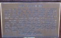
in Colorado Historical Markers The Rico, Colorado historical marker is a bronze plaque mounted on a mine car. posted by:  hummerstation hummerstation location: Colorado date approved: 07/05/2015 last visited: never |
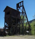 view gallery view galleryE4.3 km |  The Atlantic Cable Mine - Rico, CO The Atlantic Cable Mine - Rico, CO
in Mines The Atlantic Cable Mine headframe and part of the hoist house are located on CO Hwy 145 on the north side of Rico. posted by: hummerstation location: Colorado date approved: 07/07/2015 last visited: never |
 view gallery view gallery SE4.5 km SE4.5 km
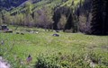
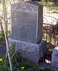
|  Rico Cemetery - Rico, CO Rico Cemetery - Rico, CO
in Worldwide Cemeteries The Rico Cemetery lies between CO Hwy 145 and the Dolores River just south of Rico, CO. posted by: hummerstation location: Colorado date approved: 07/06/2015 last visited: never |
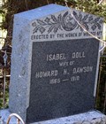 view gallery view gallerySE4.5 km |  Isabel Doll Dawson - Rico Cemetery - Rico, CO Isabel Doll Dawson - Rico Cemetery - Rico, CO
in Woodmen of the World Grave Markers/Monuments The Isabel Doll Women of Woodcraft marker is located in Rico Cemetery. posted by: hummerstation location: Colorado date approved: 07/04/2015 last visited: never |
 view gallery view gallerySE4.5 km | Emily B. Meredith - Rico Cemetery - Rico, CO in Woodmen of the World Grave Markers/Monuments The Emily B. Meredith Neighbors of Woodcraft marker is located in Rico Cemetery. posted by: hummerstation location: Colorado date approved: 07/06/2015 last visited: never |
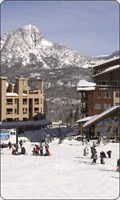 view gallery view galleryE24.6 km |  Durango Mtn Resort Durango Mtn Resort
in Ski Lodges Durango ski area posted by: kingbee location: Colorado date approved: 09/29/2011 last visited: 09/14/2019 |
 E24.6 km |  Durango Mtn resort Colorado Durango Mtn resort Colorado
in Web Cameras Durango co posted by: kingbee location: Colorado date approved: 06/15/2015 last visited: never |
 view gallery view gallery NE25.6 km NE25.6 km
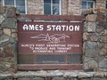
|  Ames Hydroelectric Station Ames Hydroelectric Station
in First of its Kind The Ames Station is the world's first generating station to produce and transmit alternating current. posted by:  krazykatzen krazykatzen location: Colorado date approved: 06/27/2010 last visited: never |
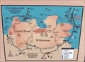 view gallery view galleryNE26.7 km |  You Are Here - A Wilderness Legacy - Ophir, CO You Are Here - A Wilderness Legacy - Ophir, CO
in 'You Are Here' Maps The "A Wilderness Legacy" panel is located on the west side of Colorado Hwy 145 between Lizard Head Pass and Ophir. posted by: hummerstation location: Colorado date approved: 07/05/2015 last visited: never |
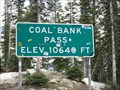 view gallery view galleryE26.7 km |  Coal Bank Pass - 10,640' Coal Bank Pass - 10,640'
in Elevation Signs Highway 550 between Silverton and Durango, Colorado. posted by: WR7X location: Colorado date approved: 04/28/2012 last visited: 07/19/2015 |
 view gallery view galleryE26.7 km | Coal Bank Pass ~ Elevation 10,660 Feet in Elevation Signs This Elevation Sign is at the summit of Coal Bank Pass on US Highway 550 between Silverton and Durango, Colorado. posted by: brwhiz location: Colorado date approved: 04/27/2013 last visited: never |
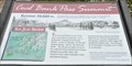
 view gallery view galleryE26.7 km | Coal Bank Pass Summit in 'You Are Here' Maps You Are Here at the summit of Coal Bank Pass on the San Juan Skyway in southwestern Colorado. posted by: brwhiz location: Colorado date approved: 09/12/2013 last visited: never |
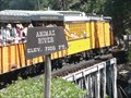 view gallery view gallerySE33.2 km | Animas River - 7200 feet in Elevation Signs This Elevation Sign is on the Durango & Silverton Narrow Guage Railroad where it crosses the Animas River. posted by: PeterNoG location: Colorado date approved: 12/12/2011 last visited: 02/13/2014 |
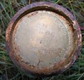 view gallery view gallery S33.6 km S33.6 km
|  La Plata PN 09294 ID 36 La Plata PN 09294 ID 36
in U.S. Benchmarks State of Colorado Division of Minerals and Geology - Reclamation Project 294, Feature ID 36 posted by: StumpAuthor location: Colorado date approved: 10/25/2009 last visited: never |
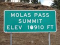 view gallery view galleryE34 km | Molas Pass - 10,910' in Elevation Signs Highway 550 between Silverton and Durango, Colorado. posted by: WR7X location: Colorado date approved: 04/28/2012 last visited: 09/12/2019 |
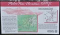 view gallery view galleryE34.1 km | Molas Pass ~ Elevation 10,899 Feet in Elevation Signs This Elevation Sign is at the summit of Molas Pass on US Highway 550 between Silverton and Durango, Colorado. posted by: brwhiz location: Colorado date approved: 04/27/2013 last visited: 09/12/2019 |
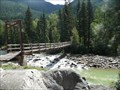 view gallery view galleryE34.9 km |  D&SNGRR / Needleton Footbridge - San Juan Nat'l Forest, Colorado D&SNGRR / Needleton Footbridge - San Juan Nat'l Forest, Colorado
in Hiking Path Footbridges This wooden footbridge crosses the Anamas River at the Needleton Flagstop "Station" of the Durango & Silverton Narrow Guage Railroad. posted by: PeterNoG location: Colorado date approved: 12/12/2011 last visited: 08/27/2008 |
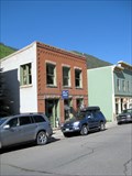 view gallery view galleryNE35.7 km |  Tomboy Mine Office - Telluride Historic District - Telluride, CO Tomboy Mine Office - Telluride Historic District - Telluride, CO
in NRHP Historic Districts - Contributing Buildings The mine office for the famous Tomboy Mine was located in Telluride. posted by: Outspoken1 location: Colorado date approved: 09/13/2015 last visited: never |
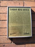 view gallery view galleryNE35.7 km | Tomboy Mine Office - Telluride, CO in Colorado Historical Markers The mine office for the famous Tomboy Mine was located in Telluride. posted by: Outspoken1 location: Colorado date approved: 04/12/2010 last visited: never |
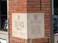 view gallery view galleryNE35.7 km |  1987 - Elks Lodge #692 - Telluride, CO 1987 - Elks Lodge #692 - Telluride, CO
in Dated Buildings and Cornerstones Nicely carved cornerstone of the former Elks Lodge in Telluride, Colorado posted by: Outspoken1 location: Colorado date approved: 02/16/2010 last visited: never |
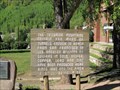 view gallery view galleryNE35.7 km | Telluride History - Telluride, CO in Colorado Historical Markers Plaques in a small park on Telluride's main street posted by: Outspoken1 location: Colorado date approved: 01/23/2011 last visited: 05/12/2023 |
 view gallery view galleryNE35.7 km |  Telluride Historic District - Telluride, CO Telluride Historic District - Telluride, CO
in U.S. National Register of Historic Places Telluride was declared a National Historic Landmark in 1961 and a National Historic District in 1966 posted by: Outspoken1 location: Colorado date approved: 01/23/2011 last visited: 05/12/2023 |
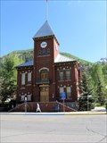
 view gallery view galleryNE35.7 km |  San Miguel County Original Courthouse - Telluride, CO San Miguel County Original Courthouse - Telluride, CO
in Town Clocks Tower Clock installed to celebrate the Nation's Bicentennial and Colorado's Centennial posted by: Outspoken1 location: Colorado date approved: 04/11/2010 last visited: 05/12/2023 |
 view gallery view galleryNE35.7 km | San Miguel County Courthouse - Telluride, CO in Colorado Historical Markers San Miguel County Courthouse built in 1887 after the original burned posted by: Outspoken1 location: Colorado date approved: 04/11/2010 last visited: 05/12/2023 |
 view gallery view galleryNE35.7 km |  San Miguel County Courthouse - Telluride, CO San Miguel County Courthouse - Telluride, CO
in Courthouses San Miguel County Courthouse built in 1887 posted by: Outspoken1 location: Colorado date approved: 04/11/2010 last visited: 05/12/2023 |
|