 view gallery view gallery S7.1 km S7.1 km
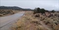
|   Dixie National Forest Water Crossing - Old Iron Town, UT Dixie National Forest Water Crossing - Old Iron Town, UT
in Bridgeless Water Crossings This bridgeless water crossing is at the edge of the Dixie National Forest - in Old Iron Town, Utah. posted by:  The Snowdog The Snowdog location: Utah date approved: 01/02/2023 last visited: never |
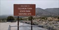 view gallery view galleryS8.2 km |  Old Iron Town State Park - Old Iron Town, Utah Old Iron Town State Park - Old Iron Town, Utah
in State/Provincial Parks The Old Iron Town Historic Site was incorporated into the Utah State Park System in 2001 - in Old Iron Town, Utah. posted by: The Snowdog location: Utah date approved: 01/02/2023 last visited: never |
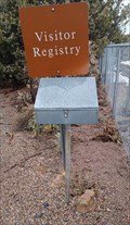 view gallery view galleryS8.2 km |  Historic Old Iron Town Guest Book - Old Iron Town, UT Historic Old Iron Town Guest Book - Old Iron Town, UT
in Guest Books This guest book is just inside the entry gate of Historic Old Iron Town - in Old Iron Town, Utah. posted by: The Snowdog location: Utah date approved: 01/03/2023 last visited: never |
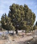
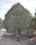 view gallery view galleryS8.2 km |  Pinyon Pine Pinyon Pine
in Flora and Fauna Information Signs This Flora and Fauna Information Sign is located on the interpretive trail through the Old Irontown site west of Cedar City, Utah. posted by: brwhiz location: Utah date approved: 11/26/2012 last visited: 09/08/2013 |
 view gallery view galleryS8.2 km | Utah Juniper in Flora and Fauna Information Signs This Flora and Fauna Information Sign is located on the interpretive trail through the Old Irontown site west of Cedar City, Utah. posted by: brwhiz location: Utah date approved: 11/26/2012 last visited: 01/02/2023 |
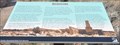 view gallery view galleryS8.2 km |  Old Irontown Old Irontown
in Utah Historical Markers This Historical Marker is mounted on a steel post near some building ruins inside Old Iron Town State Park Historic Site on Iron Town Road southwest of Utah Highway 56, west of Cedar City, Utah. posted by: brwhiz location: Utah date approved: 03/25/2013 last visited: 08/22/2014 |
 view gallery view galleryS8.2 km | Basin Wildrye in Flora and Fauna Information Signs This Flora and Fauna Information Sign is located on the interpretive trail through the Old Irontown site west of Cedar City, Utah. posted by: brwhiz location: Utah date approved: 11/26/2012 last visited: 01/02/2023 |
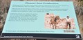 view gallery view galleryS8.2 km | Pioneer Iron Production in Utah Historical Markers This Historical Marker is mounted on a steel post near some building ruins inside Old Iron Town State Park Historic Site on Iron Town Road southwest of Utah Highway 56, west of Cedar City, Utah. posted by: brwhiz location: Utah date approved: 03/25/2013 last visited: 08/22/2014 |
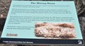 view gallery view galleryS8.2 km | The Mining Boom in Utah Historical Markers This Historical Marker is mounted on a steel post near the entrance to Old Iron Town State Park Historic Site on Iron Town Road southwest of Utah Highway 56, west of Cedar City, Utah. posted by: brwhiz location: Utah date approved: 03/25/2013 last visited: 08/22/2014 |
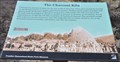 view gallery view galleryS8.2 km | The Charcoal Kiln in Utah Historical Markers This Historical Marker is mounted on a steel post in front of the remaining charcoal kiln inside Old Iron Town State Park Historic Site on Iron Town Road southwest of Utah Highway 56, west of Cedar City, Utah. posted by: brwhiz location: Utah date approved: 03/26/2013 last visited: 01/02/2023 |
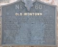 view gallery view galleryS8.2 km | Old Irontown in Utah Historical Markers This marker details the origins of an iron producing community whose legacy persisted into the middle of the twentieth century. posted by: brwhiz location: Utah date approved: 03/13/2012 last visited: 01/02/2023 |
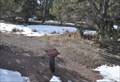
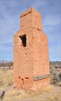
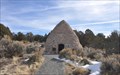 view gallery view galleryS8.2 km |  Old Iron Town Charcoal Kiln Old Iron Town Charcoal Kiln
in Ovens and Kilns This Charcoal Kiln is located just inside gthe entrance of Old Iron Town State Park Historic Site on Iron Town Road southwest of Utah Highway 56, west of Cedar City, Utah. posted by: brwhiz location: Utah date approved: 03/25/2013 last visited: 01/02/2023 |
 view gallery view galleryS8.2 km | Squawbush in Flora and Fauna Information Signs This Flora and Fauna Information Sign is located on the interpretive trail through the Old Irontown site west of Cedar City, Utah. posted by: brwhiz location: Utah date approved: 11/26/2012 last visited: 01/02/2023 |
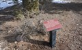
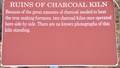 view gallery view galleryS8.2 km | Ruins of Charcoal Kiln in Utah Historical Markers This Historical Marker is mounted on a steel post in front of the ruins of one charcoal kiln inside Old Iron Town State Park Historic Site on Iron Town Road southwest of Utah Highway 56, west of Cedar City, Utah. posted by: brwhiz location: Utah date approved: 03/26/2013 last visited: 08/22/2014 |
 view gallery view galleryS8.2 km |  Iron City Blast Furnace Iron City Blast Furnace
in Iron Furnace Ruins This stack is all that remains of the "Little Blast Furnace" in the ghost town of Iron City or "Old Irontown" west of cedar City, Utah. posted by: brwhiz location: Utah date approved: 11/16/2012 last visited: 10/12/2016 |
 view gallery view galleryS8.2 km |  Old Iron Town Little Blast Furnace Chimney Old Iron Town Little Blast Furnace Chimney
in Lonely Chimneys This Lonely Chimney is about all that remains of the Little Blast Furnace in Old Iron Town State Park Historic Site on Iron Town Road southwest of Utah Highway 56, west of Cedar City, Utah. posted by: brwhiz location: Utah date approved: 03/30/2013 last visited: 08/22/2014 |
![Image for House [Ruins]](https://img.geocaching.com/waymarking/small/ee7dfb3d-8bd9-440c-966a-876560ee4708.JPG) view gallery view galleryS8.2 km | House [Ruins] in Utah Historical Markers This Historical Marker is mounted on a steel post in front of the ruins of a house inside Old Iron Town State Park Historic Site on Iron Town Road southwest of Utah Highway 56, west of Cedar City, Utah. posted by: brwhiz location: Utah date approved: 03/26/2013 last visited: 09/06/2013 |
 view gallery view galleryS8.4 km | Big Sagebrush in Flora and Fauna Information Signs This Flora and Fauna Information Sign is located on the interpretive trail through the Old Irontown site west of Cedar City, Utah. posted by: brwhiz location: Utah date approved: 11/26/2012 last visited: never |
 view gallery view galleryS8.4 km | Rubber Rabbitbrush in Flora and Fauna Information Signs This Flora and Fauna Information Sign is located on the interpretive trail through the Old Irontown site west of Cedar City, Utah. posted by: brwhiz location: Utah date approved: 11/26/2012 last visited: never |
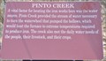 view gallery view galleryS8.4 km | Pinto Creek in Utah Historical Markers This Historical Marker is mounted on a steel post overlooking the Pinto Creek channel on the edge of Old Iron Town State Park Historic Site on Iron Town Road southwest of Utah Highway 56, west of Cedar City, Utah. posted by: brwhiz location: Utah date approved: 03/26/2013 last visited: never |
 view gallery view gallery W8.9 km W8.9 km
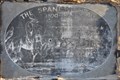
| The Spanish Trail ~ 1800-1850 in Utah Historical Markers This marker was placed where the Old Spanish Trail crosses Utah Highway 56 just east of New Castle, Utah. posted by: brwhiz location: Utah date approved: 05/18/2012 last visited: never |
 view gallery view galleryW8.9 km |  The Spanish Trail The Spanish Trail
in Wagon Roads and Trails This marker is located where the Old Spanish Trail crosses Utah Highway 56 just east of New Castle, Utah. posted by: brwhiz location: Utah date approved: 04/19/2012 last visited: never |
 view gallery view gallery SE9 km SE9 km
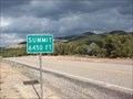
|  Iron Mountain Summit Iron Mountain Summit
in Elevation Signs The summit of Iron mountain along Highway 56 is 6450. posted by: JacobBarlow location: Utah date approved: 10/18/2007 last visited: 02/12/2011 |
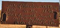 view gallery view galleryW9.2 km | Site of Blacksmith Shop on Spanish Trail in Utah Historical Markers This rather primitive historic marker is comprised of free-hand script welding on a steel plate. posted by: brwhiz location: Utah date approved: 04/19/2012 last visited: never |
 view gallery view galleryW10.3 km |  New Castle, Utah New Castle, Utah
in Wikipedia Entries I was surprised little New Castle even has a page, but there's not much to it yet. posted by: JacobBarlow location: Utah date approved: 02/01/2008 last visited: 02/12/2011 |
|