 view gallery view gallery NW4.7 km NW4.7 km
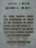
|   Harry F. Byrd Memorial Bridge Plaque Harry F. Byrd Memorial Bridge Plaque
in Citizen Memorials Plaque dedicating the nearby Blue Ridge Parkway bridge over the James River. posted by:  JL_HSTRE JL_HSTRE location: Virginia date approved: 08/15/2012 last visited: never |
 view gallery view galleryNW5 km |  Sharon Baptist Church - Big Island, Virginia Sharon Baptist Church - Big Island, Virginia
in Country Churches This country church stands on Route 122 just south of Big Island, Virginia. posted by: Sneakin Deacon location: Virginia date approved: 03/12/2009 last visited: 06/30/2010 |
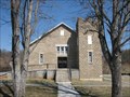
 view gallery view galleryNW5 km |  Sharon School - Big Island, VA Sharon School - Big Island, VA
in Former Schools The Sharon School is located on Route 122 just south of Big Island, Virginia. posted by: Sneakin Deacon location: Virginia date approved: 03/07/2009 last visited: never |
 view gallery view gallery W6.6 km W6.6 km
| Reed Creek Baptist Church - Sedalia, VA in Country Churches The Reed Creek Baptist Church stands on Route 122 just north of the community of Sedalia, Virginia. posted by: Sneakin Deacon location: Virginia date approved: 03/12/2009 last visited: never |
 view gallery view gallery N8.7 km N8.7 km
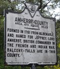
|  Amherst County/Bedford County Amherst County/Bedford County
in Virginia Historical Markers County line marker posted by: vhasler location: Virginia date approved: 09/07/2011 last visited: never |
 view gallery view galleryNW9.7 km |  James River footbridge opens - Snowden, VA James River footbridge opens - Snowden, VA
in News Article Locations The Applachian Trail (AT) is greatly improved by the opening of a 625 ft bridge across the James River. posted by: vhasler location: Virginia date approved: 09/17/2011 last visited: 06/23/2014 |
 view gallery view galleryNW9.7 km |  AT bridge across James River - Snowden, VA AT bridge across James River - Snowden, VA
in Truss Bridges The Applachian Trail (AT) cross the James River on a 625 ft truss bridge dedicated in October 2000. posted by: vhasler location: Virginia date approved: 09/17/2011 last visited: 06/23/2014 |
 view gallery view galleryNW9.7 km |  Appalachian Trail Bridge, James River, VA Appalachian Trail Bridge, James River, VA
in Hiking Path Footbridges Appalachian Trail (AT) bridge crossing the James River near Snowden, VA. U.S. 501 posted by:  garmin_geek garmin_geek location: Virginia date approved: 01/22/2009 last visited: 06/23/2014 |
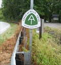 view gallery view galleryNW9.8 km |  AT foot bridge across James River - Snowden, VA AT foot bridge across James River - Snowden, VA
in Appalachian Trail The AT sign marks the parking lot for the 625 ft bridge across the James River - which was dedicated in 2000. posted by: vhasler location: Virginia date approved: 09/18/2011 last visited: 06/23/2014 |
 view gallery view galleryNW10.1 km | Marble Springs Campsite, AT Nr Snowden, VA, James River Face Wilderness in Appalachian Trail Marble Springs campsite. Some maps indicated it was a shelter. Established AT campsite with water. No shelter. posted by: garmin_geek location: Virginia date approved: 02/03/2009 last visited: 09/20/2008 |
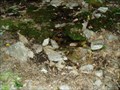 view gallery view galleryNW10.3 km |  Marble Springs, James River Face Wilderness, Appalachian Trail, VA Marble Springs, James River Face Wilderness, Appalachian Trail, VA
in Natural Springs Marble springs is a water source and camp site on the AT in the James River Face Wilderness posted by: garmin_geek location: Virginia date approved: 01/26/2009 last visited: 09/20/2008 |
 view gallery view galleryN10.5 km | AT, Northbound Sign Crossing Hwy 812, Nr Snowden, VA in Appalachian Trail AT northbound crossing of VA Hwy 812, near Snowden, VA. posted by: garmin_geek location: Virginia date approved: 01/22/2009 last visited: 09/19/2008 |
 view gallery view galleryNW10.9 km | Matts Creek Shelter, AT Nr Snowden, VA, James River Face Wilderness in Appalachian Trail We took a break at the Matts Creek Shelter on the AT during a September 2008 weekend backpacker. posted by: garmin_geek location: Virginia date approved: 01/27/2009 last visited: 09/20/2008 |
 view gallery view gallery SW11.4 km SW11.4 km
| St. Thomas Episcopal Church, Bedford County, Virginia in Country Churches The St. Thomas Episcopal Church is located on Route 122 between the communities of Sedalia and Otterville in Bedford County, Virginia posted by: Sneakin Deacon location: Virginia date approved: 03/12/2009 last visited: never |
 view gallery view gallerySW11.4 km |  St. Thomas Episcopal Church Cemetery - Sedalia, Virginia St. Thomas Episcopal Church Cemetery - Sedalia, Virginia
in Worldwide Cemeteries The St. Thomas Episcopal Church Cemetery is located on Route 122 south of the community of Sedalia, Virginia. posted by: Sneakin Deacon location: Virginia date approved: 03/07/2009 last visited: never |
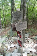
 view gallery view galleryNW11.6 km | AT In James River Face Wilderness, Nr Snowden, VA in Appalachian Trail Appalachian Trail sign post in the James River Face Wilderness posted by: garmin_geek location: Virginia date approved: 01/22/2009 last visited: 09/20/2008 |
 view gallery view galleryNW12.4 km | AT Intersection To Devil's Marbleyard, Nr Snowden, VA in Appalachian Trail Intersection signpost for trail leading off AT to down hike to the Devil's Marbleyard. September 2008 posted by: garmin_geek location: Virginia date approved: 01/22/2009 last visited: 09/20/2008 |
 view gallery view galleryNW12.6 km | Amherst County/Rockbridge County in Virginia Historical Markers County line marker on twisty US501 posted by: vhasler location: Virginia date approved: 09/07/2011 last visited: never |
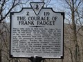 view gallery view galleryNW12.6 km | The Courage of Frank Padget in Virginia Historical Markers This historic marker is located on Route 501 at the Rockbridge - Amherst County Line. posted by: Sneakin Deacon location: Virginia date approved: 03/08/2009 last visited: 02/21/2010 |
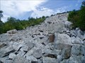 view gallery view galleryNW13.4 km |  Devil's Marbleyard, VA Devil's Marbleyard, VA
in Places of Geologic Significance Jefferson National Forest. Devil’s Marbleyard offers unforgettable impression of huge house size boulders tossed about the ridgeline and amazing view of the valley below. Worth the hike up from road below or down from the AT on the ridgeline above. posted by: garmin_geek location: Virginia date approved: 01/21/2009 last visited: 08/16/2007 |
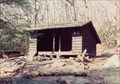 view gallery view galleryW14.2 km | AT Thunder Ridge Shelter, Appalachian Ridge/GWNF Virginia in Appalachian Trail A wonderful shelter just off of the Blue Ridge Parkway between Peaks of Otter and Petite's Gap which serves as a safe haven on the AT. Great for through hikers or weekend getaways. posted by: Eagle1977 location: Virginia date approved: 01/08/2013 last visited: never |
 view gallery view galleryW14.2 km |  Thunder Ridge Shelter, Appalachian Ridge/GWNF Virginia Thunder Ridge Shelter, Appalachian Ridge/GWNF Virginia
in Free Campsites A wonderful shelter just off of the Blue Ridge Parkway between Peaks of Otter and Petite's Gap. Great for through hikers or weekend getaways. posted by: Eagle1977 location: Virginia date approved: 01/03/2013 last visited: never |
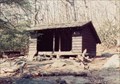 view gallery view galleryW14.2 km |  Thunder Ridge Shelter, Appalachian Ridge/GWNF Virginia Thunder Ridge Shelter, Appalachian Ridge/GWNF Virginia
in Remote Backcountry Shelters A wonderful shelter just off of the Blue Ridge Parkway between Peaks of Otter and Petite's Gap. posted by: Eagle1977 location: Virginia date approved: 01/03/2013 last visited: never |
 view gallery view galleryW14.6 km |  WA1ZMS - Bedford, Virginia WA1ZMS - Bedford, Virginia
in Amateur Radio Repeaters Located at the top of Apple Orchard Mountain posted by: flyingmoose location: Virginia date approved: 01/28/2023 last visited: never |
 view gallery view galleryW14.6 km |  Bedford Air Force Station - Bedford, Virginia Bedford Air Force Station - Bedford, Virginia
in Wikipedia Entries Located on the top of Apple Orchard Mountain. posted by: flyingmoose location: Virginia date approved: 01/03/2023 last visited: never |
|