 view gallery view gallery NW5.1 km NW5.1 km
|   Pinto Pinto
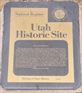
in Utah Historical Markers The town of Pinto was named after the pinto-like coloring of the surrounding rock formations. posted by:  brwhiz brwhiz location: Utah date approved: 03/14/2012 last visited: never |
 view gallery view galleryNW5.1 km |  First LDS Bishop of Pinto, Utah First LDS Bishop of Pinto, Utah
in First of its Kind The first LDS Bishop of Pinto was Richard S. Robinson. posted by: brwhiz location: Utah date approved: 03/13/2012 last visited: never |
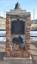 view gallery view galleryNW5.1 km |  Pinto Marker Bell - Pinto, Iron County, Utah Pinto Marker Bell - Pinto, Iron County, Utah
in Bells The bell on top of the Pinto historical marker monument is probably from the original LDS Church in Pinto, Utah. posted by: brwhiz location: Utah date approved: 03/13/2012 last visited: never |
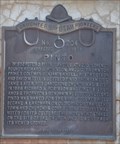
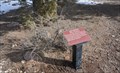
 view gallery view galleryNW5.1 km |  Pinto ~ 204 Pinto ~ 204
in D.U.P. Historic Markers The town of Pinto was named after the pinto-like coloring of the surrounding rock formations. posted by: brwhiz location: Utah date approved: 03/29/2012 last visited: never |
 view gallery view gallery NE9.7 km NE9.7 km
| Page Ranch House in Utah Historical Markers The Page Ranch House is a unique building design, and even more unique in its remote location. posted by: brwhiz location: Utah date approved: 03/13/2012 last visited: 09/10/2013 |
 view gallery view gallery SW10.8 km SW10.8 km
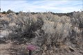
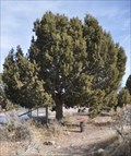
|  Cliffrose Cliffrose
in Flora and Fauna Information Signs This Flora and Fauna Information Sign is on the south side of Pine Valley Highway four miles east of Central, Utah. posted by: brwhiz location: Utah date approved: 11/16/2012 last visited: never |
 view gallery view gallery S11.1 km S11.1 km
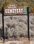
|  Pine Valley Cemetery Pine Valley Cemetery
in Worldwide Cemeteries This Cemetery is located on the north side of Pinevalley Road, just east of the junction with Grass Valley Road on the north side of Pine Valley, Utah. posted by: brwhiz location: Utah date approved: 04/15/2013 last visited: never |
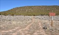 view gallery view galleryS11.1 km |  Cemetery Trail Cemetery Trail
in Hiking and walking trailheads This Hiking and Walking Trailhead is located on the west side of the Pine Valley Cemetery on the north side of Pinevalley Road, just east of the junction with Grass Valley Road on the north side of Pine Valley, Utah. posted by: brwhiz location: Utah date approved: 04/14/2013 last visited: never |
 view gallery view gallery N11.7 km N11.7 km
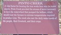
| Pinto Creek in Utah Historical Markers This Historical Marker is mounted on a steel post overlooking the Pinto Creek channel on the edge of Old Iron Town State Park Historic Site on Iron Town Road southwest of Utah Highway 56, west of Cedar City, Utah. posted by: brwhiz location: Utah date approved: 03/26/2013 last visited: never |
 view gallery view galleryN11.7 km | Rubber Rabbitbrush in Flora and Fauna Information Signs This Flora and Fauna Information Sign is located on the interpretive trail through the Old Irontown site west of Cedar City, Utah. posted by: brwhiz location: Utah date approved: 11/26/2012 last visited: never |
 view gallery view galleryN11.7 km | Big Sagebrush in Flora and Fauna Information Signs This Flora and Fauna Information Sign is located on the interpretive trail through the Old Irontown site west of Cedar City, Utah. posted by: brwhiz location: Utah date approved: 11/26/2012 last visited: never |
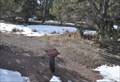
![Image for House [Ruins]](https://img.geocaching.com/waymarking/small/ee7dfb3d-8bd9-440c-966a-876560ee4708.JPG) view gallery view galleryN11.7 km | House [Ruins] in Utah Historical Markers This Historical Marker is mounted on a steel post in front of the ruins of a house inside Old Iron Town State Park Historic Site on Iron Town Road southwest of Utah Highway 56, west of Cedar City, Utah. posted by: brwhiz location: Utah date approved: 03/26/2013 last visited: 09/06/2013 |
 view gallery view galleryN11.9 km |  Iron City Blast Furnace Iron City Blast Furnace
in Iron Furnace Ruins This stack is all that remains of the "Little Blast Furnace" in the ghost town of Iron City or "Old Irontown" west of cedar City, Utah. posted by: brwhiz location: Utah date approved: 11/16/2012 last visited: 10/12/2016 |
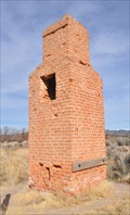 view gallery view galleryN11.9 km |  Old Iron Town Little Blast Furnace Chimney Old Iron Town Little Blast Furnace Chimney
in Lonely Chimneys This Lonely Chimney is about all that remains of the Little Blast Furnace in Old Iron Town State Park Historic Site on Iron Town Road southwest of Utah Highway 56, west of Cedar City, Utah. posted by: brwhiz location: Utah date approved: 03/30/2013 last visited: 08/22/2014 |
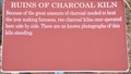 view gallery view galleryN11.9 km | Ruins of Charcoal Kiln in Utah Historical Markers This Historical Marker is mounted on a steel post in front of the ruins of one charcoal kiln inside Old Iron Town State Park Historic Site on Iron Town Road southwest of Utah Highway 56, west of Cedar City, Utah. posted by: brwhiz location: Utah date approved: 03/26/2013 last visited: 08/22/2014 |
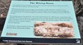 view gallery view galleryN11.9 km | The Mining Boom in Utah Historical Markers This Historical Marker is mounted on a steel post near the entrance to Old Iron Town State Park Historic Site on Iron Town Road southwest of Utah Highway 56, west of Cedar City, Utah. posted by: brwhiz location: Utah date approved: 03/25/2013 last visited: 08/22/2014 |
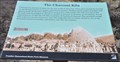 view gallery view galleryN11.9 km | The Charcoal Kiln in Utah Historical Markers This Historical Marker is mounted on a steel post in front of the remaining charcoal kiln inside Old Iron Town State Park Historic Site on Iron Town Road southwest of Utah Highway 56, west of Cedar City, Utah. posted by: brwhiz location: Utah date approved: 03/26/2013 last visited: 01/02/2023 |
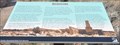
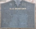 view gallery view galleryN11.9 km | Old Irontown in Utah Historical Markers This marker details the origins of an iron producing community whose legacy persisted into the middle of the twentieth century. posted by: brwhiz location: Utah date approved: 03/13/2012 last visited: 01/02/2023 |
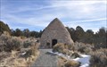 view gallery view galleryN11.9 km |  Old Iron Town Charcoal Kiln Old Iron Town Charcoal Kiln
in Ovens and Kilns This Charcoal Kiln is located just inside gthe entrance of Old Iron Town State Park Historic Site on Iron Town Road southwest of Utah Highway 56, west of Cedar City, Utah. posted by: brwhiz location: Utah date approved: 03/25/2013 last visited: 01/02/2023 |
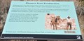 view gallery view galleryN11.9 km | Pioneer Iron Production in Utah Historical Markers This Historical Marker is mounted on a steel post near some building ruins inside Old Iron Town State Park Historic Site on Iron Town Road southwest of Utah Highway 56, west of Cedar City, Utah. posted by: brwhiz location: Utah date approved: 03/25/2013 last visited: 08/22/2014 |
 view gallery view galleryN11.9 km | Old Irontown in Utah Historical Markers This Historical Marker is mounted on a steel post near some building ruins inside Old Iron Town State Park Historic Site on Iron Town Road southwest of Utah Highway 56, west of Cedar City, Utah. posted by: brwhiz location: Utah date approved: 03/25/2013 last visited: 08/22/2014 |
 view gallery view galleryN11.9 km | Utah Juniper in Flora and Fauna Information Signs This Flora and Fauna Information Sign is located on the interpretive trail through the Old Irontown site west of Cedar City, Utah. posted by: brwhiz location: Utah date approved: 11/26/2012 last visited: 01/02/2023 |
 view gallery view galleryN11.9 km | Squawbush in Flora and Fauna Information Signs This Flora and Fauna Information Sign is located on the interpretive trail through the Old Irontown site west of Cedar City, Utah. posted by: brwhiz location: Utah date approved: 11/26/2012 last visited: 01/02/2023 |
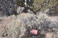
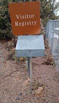 view gallery view galleryN11.9 km |  Historic Old Iron Town Guest Book - Old Iron Town, UT Historic Old Iron Town Guest Book - Old Iron Town, UT
in Guest Books This guest book is just inside the entry gate of Historic Old Iron Town - in Old Iron Town, Utah. posted by: The Snowdog location: Utah date approved: 01/03/2023 last visited: never |
 view gallery view galleryN11.9 km | Basin Wildrye in Flora and Fauna Information Signs This Flora and Fauna Information Sign is located on the interpretive trail through the Old Irontown site west of Cedar City, Utah. posted by: brwhiz location: Utah date approved: 11/26/2012 last visited: 01/02/2023 |
|