 view gallery view gallery S0.2 km S0.2 km
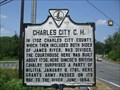
|   Charles City C. H. Charles City C. H.
in Virginia Historical Markers Virginia historical marker V-11. posted by:  archway archway location: Virginia date approved: 06/27/2010 last visited: 05/16/2019 |
 view gallery view galleryS0.3 km |  John Tyler Chairman of the Peace Convention -Charles City VA John Tyler Chairman of the Peace Convention -Charles City VA
in U.S. Civil War Sites To commemorate the efforts of John Tyler, native son, President of the United States 1841-1845. Chairman of the Peace Convention, 1861. To preserve the Union and to prevent war between the states. Erected 1961. posted by:  Don.Morfe Don.Morfe location: Virginia date approved: 10/06/2020 last visited: 10/01/2021 |
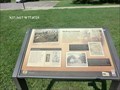
 view gallery view galleryS0.3 km |  Three Courthouse Essentials - Charles City VA Three Courthouse Essentials - Charles City VA
in Signs of History A clerk’s office, jail and tavern were located at every courthouse. The purpose of the clerk’s office and the jail are obvious, but can you guess why the tavern was just as essential? posted by: Don.Morfe location: Virginia date approved: 10/05/2020 last visited: 09/25/2021 |
 view gallery view galleryS0.3 km | Shifting Ground - Charles City VA in U.S. Civil War Sites During most of the Civil War (1861-1865), Charles City County lay between two armies: the Confederate Army of Northern Virginia safeguarding the Confederate capital of Richmond and the Union Army of the Potomac occupying the Lower Peninsula. posted by: Don.Morfe location: Virginia date approved: 10/06/2020 last visited: 10/01/2021 |
 view gallery view galleryS0.3 km |  U 276=45 USGS - Charles City, VA U 276=45 USGS - Charles City, VA
in U.S. Benchmarks Disk set into a metal pipe. Located on the grounds of the historic Charles City courthouse. posted by: archway location: Virginia date approved: 06/28/2010 last visited: 09/21/2014 |
 view gallery view gallery SE1 km SE1 km
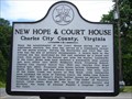
| New Hope & Court House in Virginia Historical Markers A Charles City County marker noting important history around the county court house and New Hope communities. posted by: VirginiaSeeker location: Virginia date approved: 06/01/2009 last visited: 09/21/2014 |
 view gallery view gallery SW1.1 km SW1.1 km
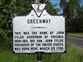
| Greenway in Virginia Historical Markers Home of John Tyler, Governor of Virginia posted by: VirginiaSeeker location: Virginia date approved: 06/01/2009 last visited: 09/21/2014 |
 view gallery view gallerySW1.1 km |  John Tyler John Tyler
in Presidential Birthplaces The tenth (1841) Vice President of the United States, and the tenth (1841-1845) President of the United States. posted by: tiki-4 location: Virginia date approved: 11/13/2005 last visited: 05/16/2019 |
 view gallery view gallerySE2.1 km | Upper Weyanoke in Virginia Historical Markers In 1617, Opechancanough, Chief of Powhatan's younger brother, gave land to the south to future governor Capt. George Yeardley. Yeardley patented it and a portion became Upper Weyanoke, a James River plantation. posted by: Don.Morfe location: Virginia date approved: 03/15/2020 last visited: 10/20/2021 |
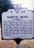 view gallery view gallerySE2.1 km | North Bend in Virginia Historical Markers This marker tells about North Bend plantation that was built by the sister of President William Henry Harrison. posted by: Markerman62 location: Virginia date approved: 03/22/2015 last visited: 03/29/2015 |
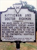 view gallery view gallerySE2.1 km | Kittiewan and Doctor Rickman in Virginia Historical Markers A marker about Kittiewan Plantation and its owner during the Revolution. posted by: Markerman62 location: Virginia date approved: 03/22/2015 last visited: 03/29/2015 |
 view gallery view gallery N2.1 km N2.1 km
| Lott Cary Birthplace in Virginia Historical Markers Virginia highway marker V-27. posted by: archway location: Virginia date approved: 06/27/2010 last visited: 09/21/2014 |
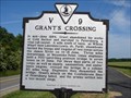 view gallery view gallerySW3.4 km | Grant's Crossing in Virginia Historical Markers Marker noting Grant's crossing of the James on June 14-15, 1864. posted by: VirginiaSeeker location: Virginia date approved: 06/01/2009 last visited: 08/05/2023 |
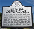 view gallery view gallerySW3.4 km | Swineyards - Willcox Wharf in Virginia Historical Markers Early settlement at Swineyards included a wharf and warehouses. Later a post office, school and churches were built in the area. posted by: VirginiaSeeker location: Virginia date approved: 06/01/2009 last visited: 05/16/2019 |
 view gallery view gallerySW3.5 km | Grant's Crossing - Charles City VA in American Civil War Monuments and Memorials Marker is near Charles City, Virginia, in Charles City County. Marker is on John Tyler Memorial Highway (Virginia Route 5). The Marker was erected in 1993 by the Department of Historic Resources. (Marker Number V-9.) posted by: Don.Morfe location: Virginia date approved: 08/06/2023 last visited: 08/06/2023 |
 view gallery view gallerySW3.9 km | Wilcox’s Landing-Crossing the James - Charles City VA in U.S. Civil War Sites The Army of the Potomac along with artillery and several thousand supply wagons moved south of the James. It was one of the few times a Union commander had managed to outmaneuver Confederate commander Gen. Robert E. Lee. posted by: Don.Morfe location: Virginia date approved: 06/26/2023 last visited: 06/26/2023 |
 view gallery view gallerySW3.9 km |  Battle at Willcox's Landing - Charles City VA Battle at Willcox's Landing - Charles City VA
in Battlefields From June 14 to 17 – here at Wilcox’s landing and three miles downstream at Weyanoke Point – the Army of the Potomac along with artillery and several thousand supply wagons moved south of the James. posted by: Don.Morfe location: Virginia date approved: 11/13/2020 last visited: 10/16/2021 |
 view gallery view gallery E4.7 km E4.7 km
| President Tyler's Home in Virginia Historical Markers Sherwood Forest Plantation was the home of President John Tyler from its purchase in 1842 until his death in 1862. posted by: xptwo location: Virginia date approved: 08/07/2012 last visited: 01/10/2023 |
 view gallery view gallerySE4.8 km | Kittiewan Plantation - Charles City VA in U.S. Civil War Sites Land referred to as Kenwon, mentioned in a 1618 grant to Gov. George Yeardley. Patented in 1632 by Lennon Pierce. Occupied by Union Army in June 1864. posted by: Don.Morfe location: Virginia date approved: 10/06/2020 last visited: 10/01/2021 |
 view gallery view gallery W6.9 km W6.9 km
| Evelynton - Charles City VA in American Civil War Monuments and Memorials Marker is near Charles City, Virginia, in Charles City County on John Tyler Memorial Highway (Virginia Route 5). The marker was erected in 1985 by Department of Conservation and Historic Resources. (Marker Number V-22.) posted by: Don.Morfe location: Virginia date approved: 08/08/2023 last visited: 08/08/2023 |
 view gallery view galleryW6.9 km | Evelynton - Charles City VA in Battlefields Marker is near Charles City, Virginia, in Charles City County on John Tyler Memorial Highway (Virginia Route 5). The marker was erected in 1985 by Department of Conservation and Historic Resources. (Marker Number V-22.) posted by: Don.Morfe location: Virginia date approved: 08/06/2023 last visited: 08/06/2023 |
 view gallery view galleryE7.1 km | Fort Pocahontas in Virginia Historical Markers Fort Pocahontas was an earthen fort built and initially manned primarily by Union Colored forces near the marker site. They withstood a Confederate attack and were able to keep the fort open to protect Union river traffic. posted by: xptwo location: Virginia date approved: 07/28/2012 last visited: 04/21/2016 |
 view gallery view galleryE7.1 km | Sherwood Forest in Virginia Historical Markers Sherwood Forest Plantation was the home of President John Tyler from its purchase in 1842 until his death in 1862. It is still owned by the Tyler family. posted by: xptwo location: Virginia date approved: 08/07/2012 last visited: 04/21/2016 |
 view gallery view galleryE7.1 km | Kennon's Landing in Virginia Historical Markers Historical marker telling the story of Kennon's Landing, located south of the marker on a site on the James River. The history of Kennon's Landing goes back to the 1700s when shipping by river was the most efficient and effective means of transport. posted by: xptwo location: Virginia date approved: 07/28/2012 last visited: 04/21/2016 |
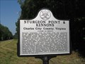 view gallery view galleryE7.1 km | Sturgeon Point & Kennons in Virginia Historical Markers This historical marker was placed by Charles City County along Virginia Route 5, near the site of Sturgeon Point and Kennon's Landing. posted by: xptwo location: Virginia date approved: 08/07/2012 last visited: 04/21/2016 |
|