 view gallery view gallery W0.2 km W0.2 km
|   Achilles, VA. 23001 Achilles, VA. 23001
in U.S. Post Offices A rural VA post office posted by:  pud & pop pud & pop location: Virginia date approved: 02/08/2008 last visited: 07/04/2012 |
 view gallery view gallery SW1.8 km SW1.8 km
| Bena, VA. 23108 in U.S. Post Offices A rural VA Post Office posted by: pud & pop location: Virginia date approved: 02/08/2008 last visited: never |
 view gallery view galleryW5.3 km | Hayes, VA. 23072 in U.S. Post Offices A rural VA post office posted by: pud & pop location: Virginia date approved: 02/08/2008 last visited: 07/04/2012 |
 view gallery view gallerySW6.1 km | Gloucester Pt., VA. 23062 in U.S. Post Offices A rural VA post office posted by: pud & pop location: Virginia date approved: 02/08/2008 last visited: 07/04/2012 |
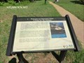
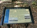
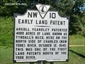 view gallery view gallerySW6.3 km |  FIRST - Land Patents North of the York River-Early Land Patent - Gloucester Point VA FIRST - Land Patents North of the York River-Early Land Patent - Gloucester Point VA
in First of its Kind First land patents north of the York River was Tyndall's Neck on October 12, 1640. posted by:  Don.Morfe Don.Morfe location: Virginia date approved: 04/03/2023 last visited: 04/03/2023 |
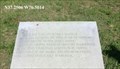
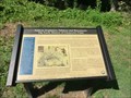
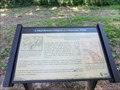
 view gallery view gallerySW6.3 km |  Early Land Patent Early Land Patent
in Virginia Historical Markers Argoll Yeardley patented 4000 acres of land, known as Tyndall's Neck, here on the north side of Charles (now York) River, October 12, 1640. posted by: Don.Morfe location: Virginia date approved: 03/19/2020 last visited: 09/24/2021 |
 view gallery view gallerySW6.3 km |  Battle of Gloucester - Gloucester Point VA Battle of Gloucester - Gloucester Point VA
in Battlefields Near this place on October 19, 1781, a surrender occurred one hour after the Surrender at Yorktown. posted by: Don.Morfe location: Virginia date approved: 11/08/2020 last visited: 09/24/2021 |
 view gallery view gallerySW6.3 km |  After the Surrender at Yorktown - Gloucester Point VA After the Surrender at Yorktown - Gloucester Point VA
in Signs of History Near this place on October 19, 1781, a surrender occurred one hour after the Surrender at Yorktown. posted by: Don.Morfe location: Virginia date approved: 11/01/2020 last visited: 09/24/2021 |
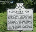
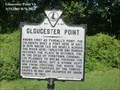 view gallery view gallerySW6.3 km | Gloucester Point in Virginia Historical Markers Known first as Tyndall's Point. The colonists built a fort here in 1667. posted by: Don.Morfe location: Virginia date approved: 03/19/2020 last visited: 09/24/2021 |
 view gallery view gallerySW6.3 km |  Gloucester Point - Gloucester Point VA Gloucester Point - Gloucester Point VA
in American Civil War Monuments and Memorials Marker is in Gloucester Point, Virginia, in Gloucester County, 1376 Vernon Street, 23062, at the entrance to Tyndall's Point Park. Erected 1928 by Conservation & Development Commission. Marker Number 9-NA. posted by: Don.Morfe location: Virginia date approved: 08/28/2023 last visited: 08/28/2023 |
 view gallery view gallerySW6.3 km | Welcome to Gloucester Point-A Point for the Defense - Gloucester Point VA in U.S. Civil War Sites You are standing at the entrance to Tyndall’s Point Park. These protected remains of a Civil War fort survive to help take us back into the history of Gloucester Point. posted by: Don.Morfe location: Virginia date approved: 10/31/2020 last visited: 09/24/2021 |
 view gallery view gallerySW6.3 km | Battle of Gloucester Point (1861) - Gloucester Point VA in Battlefields The Battle of Gloucester Point, Virginia was an inconclusive exchange of cannon fire between a shore battery on the York River which was manned by Virginia (soon to be Confederate) forces and the Union gunboat USS Yankee. posted by: Don.Morfe location: Virginia date approved: 11/08/2020 last visited: 09/24/2021 |
 view gallery view gallerySW6.3 km |  Tyndalls Point Park - Gloucester Point VA Tyndalls Point Park - Gloucester Point VA
in Official Local Tourism Attractions Civil War Trails site with self-guided interpretative walking trail. Public park open, seven days a week. The site of the first shot of the Civil War fired in the State of Virginia. posted by: Don.Morfe location: Virginia date approved: 04/03/2023 last visited: 04/03/2023 |
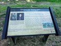
 view gallery view gallerySW6.3 km |  Natives, Explorers, Tobacco and Buccaneers - Gloucester Point VA Natives, Explorers, Tobacco and Buccaneers - Gloucester Point VA
in Civil Rights Memorials In 1600, this tidewater land was part of a vast American Indian empire ruled by the Powhatan nation. English mariner and mapmaker Robert Tyndall found a narrow entrance to the York River in 1608. posted by: Don.Morfe location: Virginia date approved: 04/04/2023 last visited: 04/03/2023 |
 view gallery view gallerySW6.3 km | Natives, Explorers, Tobacco and Buccaneers - Gloucester Point VA in Signs of History In 1600, this tidewater land was part of a vast American Indian empire ruled by the Powhatan nation. English mariner and mapmaker Robert Tyndall found a narrow entrance to the York River in 1608. posted by: Don.Morfe location: Virginia date approved: 11/01/2020 last visited: 09/24/2021 |
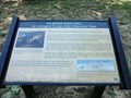
 view gallery view gallerySW6.3 km | Gloucester Point The 1781 Siege of Yorktown - Gloucester Point VA in Signs of History While the earthworks in front of you date to the Civil War, during the 1781 Siege of Yorktown, the British also constructed extensive fortifications in this area. posted by: Don.Morfe location: Virginia date approved: 11/01/2020 last visited: 09/24/2021 |
 view gallery view gallerySW6.4 km | A Vital British Outpost at Gloucester Point - Gloucester Point VA in Signs of History In 1781, large armies and important events came to Gloucester Point and to Yorktown across the river. An 8,300 man British army, commanded by General Charles Lord Cornwallis, marched to the Virginia coast to establish a naval base. posted by: Don.Morfe location: Virginia date approved: 11/01/2020 last visited: 09/24/2021 |
 view gallery view gallerySW6.4 km | The Battle of the Hook - Gloucester Point VA in Battlefields One of the largest cavalry battles of the Revolution was fought a few miles north of Gloucester Point. The Battle of the Hook set the stage for the American victory at Yorktown. posted by: Don.Morfe location: Virginia date approved: 11/08/2020 last visited: 09/24/2021 |
 view gallery view gallerySW6.4 km | Attacking with “Decisive Vigor” The Battle of the Hook - Gloucester Point VA in Signs of History One of the largest cavalry battles of the Revolution was fought a few miles north of Gloucester Point. The Battle of the Hook set the stage for the American victory at Yorktown. posted by: Don.Morfe location: Virginia date approved: 11/01/2020 last visited: 09/24/2021 |
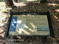
 view gallery view gallerySW6.4 km | The British Safety Valve An Attempted Escape from Gloucester Point - Gloucester Point VA in Signs of History On the night of October 16, 1871, after almost three weeks of the American-French siege, the British defenses at Yorktown were crumbling. In a last ditch effort to save his army, General Cornwallis decided on a desperate plan. posted by: Don.Morfe location: Virginia date approved: 11/01/2020 last visited: 09/24/2021 |
 view gallery view gallerySW6.4 km | Where North Meets South Virginia Fortifies Gloucester Point - Gloucester Point VA in Battlefields As Virginia joined the Confederacy in April, 1861, its leaders were soon defending the Chesapeake tidewater. Within days (May 7, 1861), the first shots of the war in Virginia were fired at Gloucester Point by Union gunboats. posted by: Don.Morfe location: Virginia date approved: 04/05/2023 last visited: 04/03/2023 |
 view gallery view gallerySW6.4 km | Where North Meets South Virginia Fortifies Gloucester Point - Gloucester Point VA in U.S. Civil War Sites Eighty years after the decisive events at Yorktown, a major war again came to Gloucester Point. This time it was a civil war. As Virginia joined the Confederacy in April, 1861, its leaders were soon defending the Chesapeake tidewater. posted by: Don.Morfe location: Virginia date approved: 11/01/2020 last visited: 09/24/2021 |
 view gallery view gallerySW6.4 km | FIRST - Shots of the Civil War in Virginia- Where North Meets South Virginia Fortifies Gloucester Point - Gloucester Point VA in First of its Kind As Virginia joined the Confederacy in April, 1861, its leaders were soon defending the Chesapeake tidewater. Within days (May 7, 1861), the first shots of the war in Virginia were fired at Gloucester Point by Union gunboats. posted by: Don.Morfe location: Virginia date approved: 04/03/2023 last visited: 04/03/2023 |
 view gallery view gallerySW6.4 km | On to Richmond! McClellan Invades the Virginia Tidewater - Gloucester Point VA in U.S. Civil War Sites The York River Confederate defenses were tested early in the Civil War. A large Union force, the Army of the Potomac, commanded by Major General George B. McClellan, steamed down the Chesapeake Bay from Washington D.C. in March, 1862. posted by: Don.Morfe location: Virginia date approved: 11/01/2020 last visited: 09/24/2021 |
 view gallery view gallerySW6.4 km | Still Defending Virginia’s Shores Gloucester Point Today - Gloucester Point VA in Signs of History When Robert Tyndall sailed past Gloucester Point in 1608, the York River and the Chesapeake Bay were unspoiled worlds. His fellow explorer, John Smith, boasted that Virginia was a “fruitful and delightsome land.” posted by: Don.Morfe location: Virginia date approved: 11/01/2020 last visited: 09/24/2021 |
|