 view gallery view gallery E3.5 km E3.5 km
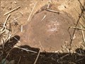
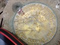
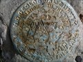
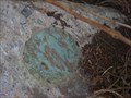
|   HB1551 - MASSAC HB1551 - MASSAC
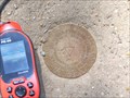
in U.S. Benchmarks A triangulation station disk set into the top of a square concrete monument. posted by:  trailhound1 trailhound1 location: Kentucky date approved: 06/30/2011 last visited: 06/29/2011 |
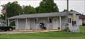
 view gallery view gallery N4.2 km N4.2 km
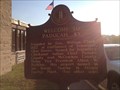
|  Welcome to Paducah/Barkley Field Welcome to Paducah/Barkley Field
in Kentucky Historical Markers A historical marker located outside the Barkley Field (airport) terminal describing the history of Paducah. posted by: trailhound1 location: Kentucky date approved: 06/19/2012 last visited: 06/18/2012 |
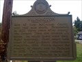
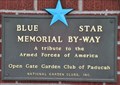 view gallery view galleryN4.2 km |  Barkley Regional Airport ~ West Paducah, Kentucky Barkley Regional Airport ~ West Paducah, Kentucky
in Blue Star Memorial Highway Markers This Blue Star Memorial Highway Marker is mounted on the front of the terminal building of Barkley Regional Airport located at 2901 Fisher Road, in West Paducah, Kentucky. posted by: brwhiz location: Kentucky date approved: 07/05/2013 last visited: never |
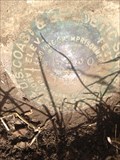
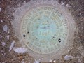 view gallery view galleryN4.7 km | HB0383 - M389 in U.S. Benchmarks HB0383 - M389 benchmark set in concrete guardrail of bridge on old US 60. posted by: trailhound1 location: Kentucky date approved: 06/19/2012 last visited: 06/18/2012 |
 view gallery view gallery NW4.8 km NW4.8 km
| HB0384 - L389 in U.S. Benchmarks HB0384 - L389 benchmark set in the center of the top of a concrete headwall along old US 60. posted by: trailhound1 location: Kentucky date approved: 06/19/2012 last visited: 06/18/2012 |
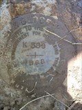 view gallery view galleryNW5.5 km | HB0385 - K389 in U.S. Benchmarks HB0385 - K389 benchmark set in the top of a concrete headwall along US 60 three feet below the highway. posted by: trailhound1 location: Kentucky date approved: 06/19/2012 last visited: 06/18/2012 |
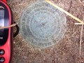 view gallery view galleryN6.1 km | HB0376 - Q389 in U.S. Benchmarks HB0376 - Q389 marker set in the top of a concrete post next to a metal witness post just off KY 305 near the railroad crossing. posted by: trailhound1 location: Kentucky date approved: 06/19/2012 last visited: 06/18/2012 |
 view gallery view galleryNW6.4 km | HB0387 - J389 in U.S. Benchmarks HB0387 - J389 benchmark set in the top of a concrete post next to a metal witness post. posted by: trailhound1 location: Kentucky date approved: 06/19/2012 last visited: 06/18/2012 |
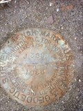
 view gallery view galleryN6.9 km | HB0375 - 64M USGS in U.S. Benchmarks A U.S. GEOLOGICAL SURVEY DISK LABELED "HB0375 - 64M USGS" SET IN THE TOP OF A CONCRETE POST WHICH PROJECTS 6 INCHES. posted by: trailhound1 location: Kentucky date approved: 06/19/2012 last visited: 06/18/2012 |
 view gallery view gallery SW7.7 km SW7.7 km
|  Lovelaceville, Kentucky 42060 Lovelaceville, Kentucky 42060
in U.S. Post Offices This Post Office is located at 142 N Broadway Street in Lovelaceville, Kentucky. posted by: brwhiz location: Kentucky date approved: 06/27/2013 last visited: never |
 view gallery view galleryN8.5 km | Wilmington in Kentucky Historical Markers Historical Marker noting first county seat and court house for McCracken County, Kentucky. Located at intersection of Wilmington Road and KY 358 between Paducah & Atomic Energy Plant. posted by: trailhound1 location: Kentucky date approved: 10/05/2010 last visited: 01/19/2013 |
 view gallery view galleryNW8.7 km | HB0389 - L130 in U.S. Benchmarks HB0389 - L130 set in top of concrete headwall next to US60. posted by: trailhound1 location: Kentucky date approved: 06/19/2012 last visited: 06/18/2012 |
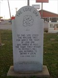 view gallery view galleryE9.3 km | The Lone Oak - Lone Oak, Kentucky in Kentucky Historical Markers A marble marker describing the creation of Lone Oak, Kentucky. posted by: trailhound1 location: Kentucky date approved: 07/24/2011 last visited: 03/22/2011 |
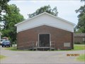 view gallery view galleryN9.7 km |  Carneal Chapel Missionary Baptist Church - Grahamville, KY Carneal Chapel Missionary Baptist Church - Grahamville, KY
in Baptist Churches Carneal Chapel Missionary Baptist Church is a single story wood and brick church located in Grahamville (West Paducah), Kentucky at the intersection of Metropolis Lake Road and Ogden Landing Road. posted by: trailhound1 location: Kentucky date approved: 06/25/2011 last visited: 06/25/2011 |
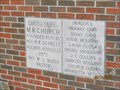 view gallery view galleryN9.7 km |  1876 - Carneal Chapel Missionary Baptist Church 1876 - Carneal Chapel Missionary Baptist Church
in Dated Buildings and Cornerstones Carneal Missionary Baptist Church is a single story wood and brick church located in Grahamville (West Paduch), Kentucky at the intersection of Metropolis Lake Road and Ogden Landing Road. posted by: trailhound1 location: Kentucky date approved: 06/25/2011 last visited: 06/25/2011 |
 view gallery view gallery SE9.8 km SE9.8 km
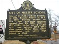
| Melber School in Kentucky Historical Markers A road side historical marker commemorating the site of the Melber School prior to consolidation of the Graves County school district. posted by: trailhound1 location: Kentucky date approved: 12/30/2010 last visited: 12/29/2010 |
 view gallery view galleryE10.1 km | USGS H24 in U.S. Benchmarks A USGS Survey Marker located at the intersection of Kreb Station Road and Friendship Road in southern McCracken County, Kentucky posted by: trailhound1 location: Kentucky date approved: 02/03/2012 last visited: 01/19/2012 |
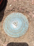 view gallery view galleryNW10.1 km | HB0391 - KEVIL in U.S. Benchmarks HB0391 - KEVIL triangulation station set in top of concrete post next to metal witness post. posted by: trailhound1 location: Kentucky date approved: 06/19/2012 last visited: 06/18/2012 |
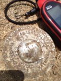 view gallery view galleryNW10.1 km | HB1257 - KEVIL 1930 RM 3 1976 in U.S. Benchmarks HB1257 - KEVIL 1930 RM 3 is an aluminum marker set flush with the ground 1 foot from power pole posted by: trailhound1 location: Kentucky date approved: 06/19/2012 last visited: 06/18/2012 |
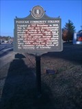
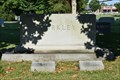 view gallery view galleryE10.5 km |  Alben William Barkley - Paducah, Ky. Alben William Barkley - Paducah, Ky.
in Grave of a Famous Person Alben Barkley served as the 35th Vice President of the United State during the Administration of President Harry S Truman posted by: Sneakin Deacon location: Kentucky date approved: 03/04/2019 last visited: 11/21/2020 |
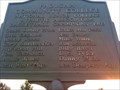
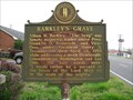 view gallery view galleryE10.6 km | Barkley's Grave - Paducah, Kentucky in Kentucky Historical Markers Historical marker commemorating the grave of former Senator and Vice President of the United States. Located in front of Mt. Kenton Cemetery. posted by:  BruceS BruceS location: Kentucky date approved: 05/11/2009 last visited: 11/21/2020 |
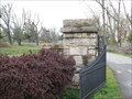 view gallery view galleryE10.6 km |  Mt. Kenton Cemetery - Paducah, Kentucky Mt. Kenton Cemetery - Paducah, Kentucky
in Worldwide Cemeteries Cemetery on the southwest side of Paducah, Kentucky. posted by: BruceS location: Kentucky date approved: 05/12/2009 last visited: 07/23/2018 |
 view gallery view galleryE10.8 km | Paducah Community College in Kentucky Historical Markers Historical marker on US62/Blandville Road commemorating Paducah Community College. posted by: trailhound1 location: Kentucky date approved: 11/08/2010 last visited: 10/22/2021 |
 view gallery view galleryE10.8 km | National Basketball Champions in Kentucky Historical Markers Sign marking Paducah Community College as the 1969 National Junior College Athletic Association Basketball Champions. Located outside Haws Gymnasium. posted by: trailhound1 location: Kentucky date approved: 10/05/2010 last visited: 10/05/2010 |
 view gallery view galleryE10.9 km | HB0462 - I24 L 9 in U.S. Benchmarks A Commonwealth of Kentucky, and US Coast and Geodetic Survey BENCH MARK DISK DRILLED IN THE NORTHWEST END OF HEADWALL OVER CULVERT AND STAMPED I24-L9-1965. posted by: trailhound1 location: Kentucky date approved: 06/30/2011 last visited: 06/29/2011 |
|