 view gallery view gallery E17.1 km E17.1 km
|   Oklahoma / Colorado on Highway 385 - Campo, CO Oklahoma / Colorado on Highway 385 - Campo, CO
in Border Crossings Highway 385 crosses the Oklahoma / Colorado border about midway between Campo, Colorado and Boise City, Oklahoma. posted by:  The Snowdog The Snowdog location: Colorado date approved: 09/18/2023 last visited: never |
 view gallery view gallery NE18.5 km NE18.5 km
|  First Homesteaders of BACA County - Campo, CO First Homesteaders of BACA County - Campo, CO
in First of its Kind This pair of Dedication Sculptures sit on the South end of Campo, CO along Main St. (On the west side of the road) They are next to the "Welcome To Campo" sign posted by:  condor1 condor1 location: Colorado date approved: 07/04/2010 last visited: 09/10/2023 |
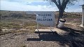
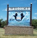 view gallery view galleryNE18.5 km |  Campo (center of Town) Welcome Sign - Campo, CO Campo (center of Town) Welcome Sign - Campo, CO
in Artistic Welcome Signs Campo, Colorado is proclaimed as "EMERALD OF THE PLAINS" posted by: condor1 location: Colorado date approved: 06/12/2013 last visited: 09/10/2023 |
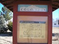 view gallery view galleryNE18.7 km |  Explore Southeast Colorado - Campo, CO Explore Southeast Colorado - Campo, CO
in Colorado Historical Markers Found in the small Colorado town of Campo, this 3 Panel Historical Marker has seen better days. posted by: condor1 location: Colorado date approved: 02/05/2012 last visited: 09/10/2023 |
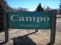 view gallery view galleryNE18.7 km |  Campo, CO Campo, CO
in Welcome Signs Campo, Colorado is proclaimed as "EMERALD OF THE PLAINS" posted by: condor1 location: Colorado date approved: 02/13/2012 last visited: 09/10/2023 |
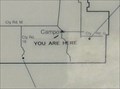 view gallery view galleryNE18.7 km |  "You Are Here" - in Campo, CO "You Are Here" - in Campo, CO
in 'You Are Here' Maps Wow, You Are Here in Campo Colorado when you visit this waymark. posted by: condor1 location: Colorado date approved: 06/04/2012 last visited: 09/10/2023 |
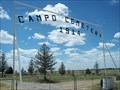 view gallery view galleryNE20 km |  Campo Cemetery - Campo, CO Campo Cemetery - Campo, CO
in Worldwide Cemeteries The Campo Cemetery is located about 1.25 miles east of Campo, on the south side of Co Rd J. posted by: condor1 location: Colorado date approved: 07/06/2010 last visited: 09/10/2023 |
 view gallery view gallery W21.2 km W21.2 km
|  Dinosaur Tracks - Black Mesa, OK Dinosaur Tracks - Black Mesa, OK
in Official Local Tourism Attractions These dinosaur tracks have been preserved in a sandstone strata next to Carrizo Creek - near Black Mesa, Oklahoma. posted by: The Snowdog location: Oklahoma date approved: 06/26/2021 last visited: never |
 view gallery view galleryW21.2 km |  Dinosaur Tracks - Black Mesa, OK Dinosaur Tracks - Black Mesa, OK
in Petrosomatoglyphs These dinosaur tracks have been preserved in a sandstone strata next to Carrizo Creek - near Black Mesa, Oklahoma. posted by: The Snowdog location: Oklahoma date approved: 06/25/2021 last visited: never |
 view gallery view gallery SE21.6 km SE21.6 km
|  Santa Fe Trail Roadside Picnic Table - Boise City, OK Santa Fe Trail Roadside Picnic Table - Boise City, OK
in Highway Rest Areas This small rest area on Highway 385 is at a crossing with the historic Santa Fe Trail - north of Boise City, Oklahoma. posted by: The Snowdog location: Oklahoma date approved: 09/13/2023 last visited: never |
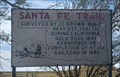 view gallery view gallerySE21.6 km |  The Santa Fe Trail - Boise City, OK The Santa Fe Trail - Boise City, OK
in Wagon Roads and Trails This small road side pull out has four markers commemorating the history and impact of the Santa Fe Trail - north of Boise City, Oklahoma. posted by: The Snowdog location: Oklahoma date approved: 09/14/2023 last visited: never |
 view gallery view gallerySE21.6 km |  Santa Fe Trail - Boise City, OK Santa Fe Trail - Boise City, OK
in Oklahoma Historical Markers This historical marker is located in the panhandle of Oklahoma about 8 miles north of Boise City and 7 miles south of the Oklahoma / Colorado border along Hwy 287 / 385 posted by: condor1 location: Oklahoma date approved: 11/02/2009 last visited: 05/10/2021 |
 view gallery view gallery S22.5 km S22.5 km
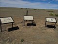
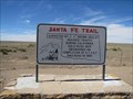
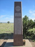
| Santa Fe Trail in Oklahoma Historical Markers Set of three informational markers about the Santa Fe Trail along Hwy 325 northwest of Boise City, Oklahoma. posted by:  BruceS BruceS location: Oklahoma date approved: 04/12/2012 last visited: 07/04/2018 |
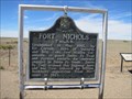 view gallery view galleryS22.5 km | Fort Nichols in Oklahoma Historical Markers Marker giving history of fort along the Santa Fe Trail located at highway pull off along Hwy 325 northwest of Boise City, Oklahoma posted by: BruceS location: Oklahoma date approved: 04/13/2012 last visited: 07/04/2018 |
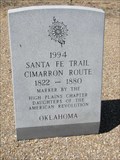 view gallery view galleryS22.5 km | Santa Fe Trail - Cimarron Route in Oklahoma Historical Markers Stone marker placed the the Daughters of the American Revolution marking route of Santa Fe Trail. posted by: BruceS location: Oklahoma date approved: 04/13/2012 last visited: 07/04/2018 |
 view gallery view galleryS22.5 km | Santa Fe Trail in Oklahoma Historical Markers Marker giving brief information of Santa Fe Trail along Hwy 325. posted by: BruceS location: Oklahoma date approved: 04/11/2012 last visited: 07/04/2018 |
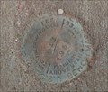 view gallery view galleryW23.3 km |  GL0356 (K 12) at the Kenton Union Grade School - Kenton, OK GL0356 (K 12) at the Kenton Union Grade School - Kenton, OK
in U.S. Benchmarks U.S. Coast and Geodesic Survey Benchmark Disk on an old school house in Kenton, OK posted by: The Snowdog location: Oklahoma date approved: 07/06/2018 last visited: never |
 view gallery view galleryW23.7 km |  Kenton Mercantile WiFi Kenton Mercantile WiFi
in Wi-Fi Hotspots One of the last of the old small-town general stores. posted by: the Tribe of Two location: Oklahoma date approved: 04/29/2007 last visited: 07/05/2018 |
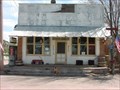 view gallery view galleryW23.7 km |  Kenton Mercantile Restaurant Kenton Mercantile Restaurant
in Classic BBQ and Sandwich Joints The best burgers in Kenton! Closed on Tuesdays. Under new management as of April 28, 2007. posted by: the Tribe of Two location: Oklahoma date approved: 04/29/2007 last visited: 07/05/2018 |
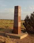
 view gallery view galleryW25.6 km |  Oklahoma High Point (Black Mesa) Oklahoma High Point (Black Mesa)
in Geographic High Points Though it is not the highest point of the mesa itself, this spot on Black Mesa is the highest point in the State of Oklahoma. posted by: madmallard location: Oklahoma date approved: 03/24/2011 last visited: 07/05/2018 |
 view gallery view galleryW25.6 km |  Black Mesa - near Kenton, OK Black Mesa - near Kenton, OK
in Mountain Summits The highest point in the state of Oklahoma, on Black Mesa, north of Kenton, OK. posted by: The Snowdog location: Oklahoma date approved: 08/31/2018 last visited: never |
 view gallery view galleryW25.6 km |  Black Mesa High Point - Kenton, OK Black Mesa High Point - Kenton, OK
in Summit Registers Summit register atop Black Mesa, at the highest point in Oklahoma. posted by: The Snowdog location: Oklahoma date approved: 08/27/2018 last visited: never |
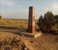
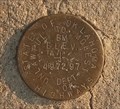 view gallery view galleryW25.6 km | GL1426 (OSHD BM 4972) on Black Mesa - near Kenton, OK in U.S. Benchmarks State of Oklahoma Highways Elevation Disk atop Black Mesa, north of Kenton, OK posted by: The Snowdog location: Oklahoma date approved: 07/06/2018 last visited: never |
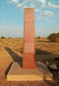 view gallery view galleryW25.6 km | GL1425 (OK HIGH PT MON) on Black Mesa - near Kenton, OK in U.S. Benchmarks Granite obelisk atop Black Mesa, near Kenton, OK posted by: The Snowdog location: Oklahoma date approved: 07/16/2018 last visited: never |
 view gallery view galleryW25.6 km |  Black Mesa - Kenton, OK Black Mesa - Kenton, OK
in American Guide Series Black Mesa, the highest point in the state, is described in the WPA Guide to 1930s Oklahoma - near Kenton, Oklahoma. posted by: The Snowdog location: Oklahoma date approved: 11/23/2021 last visited: never |
|