 view gallery view gallery W12.7 km W12.7 km
|   Mitchell Peak Mitchell Peak
in Mountain Summits Beautiful hike and wonderful site in Kings Canyon National Park. posted by:  wilsonjw wilsonjw location: California date approved: 08/30/2005 last visited: never |
 view gallery view gallery SW15.4 km SW15.4 km
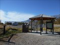
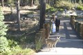
|  Eastern Sierra Visitor Center, Inyo N. F. - Long Pine CA Eastern Sierra Visitor Center, Inyo N. F. - Long Pine CA
in Tourist Information Centers - Visitor Centers Thirteen of the peaks over 14,000 feet are in Inyo County. Permits are required for Wilderness access and trails.
There is a picnic area, bookstore and gift shop, area maps. posted by:  sbcamper sbcamper location: California date approved: 08/14/2022 last visited: never |
 view gallery view gallery NW16.4 km NW16.4 km
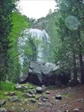
|  Grizzly Falls, California Grizzly Falls, California
in Waterfalls Impressive tributary to the Kings River posted by: Bernd das Brot Team location: California date approved: 05/17/2008 last visited: 06/21/2012 |
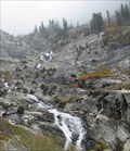 view gallery view gallerySW18.5 km | Tokopah Falls - Sequoia National Park, CA in Waterfalls The Tokopah Falls is located at the end of the 1.7 mile Tokopah Valley Trail, which begins at the Lodgepole Campground in Sequoia National Park, CA. posted by: Merlin-N-Mim location: California date approved: 10/25/2009 last visited: 06/14/2014 |
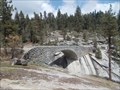
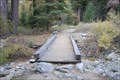 view gallery view gallerySW18.8 km |  Tokopah Valley Trail Bridge - Sequoia National Park, California Tokopah Valley Trail Bridge - Sequoia National Park, California
in Hiking Path Footbridges This is a beautiful moderate 1.7 mile hiking trail to Tokopah Falls. The bridge crosses a small stream that cuts the trail. posted by: teeoff2 location: California date approved: 11/06/2008 last visited: 11/07/2010 |
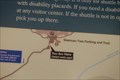
 view gallery view gallerySW20.6 km |  Tokopah Valley Falls Trail - Sequoia N park - CA Tokopah Valley Falls Trail - Sequoia N park - CA
in Hiking and walking trailheads From the camp grounds. Fee to enter the National Park. Separate fees to camp, vary from tent to hook ups. This begins at a crossing of the Marble Fork Kaweah River. posted by: sbcamper location: California date approved: 07/24/2015 last visited: never |
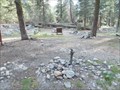
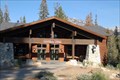
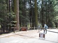
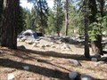 view gallery view gallerySW20.9 km |  Lodgepole Campground - Sequoia National Park, CA Lodgepole Campground - Sequoia National Park, CA
in Campgrounds The Lodgepole Campground is at a 6700-foot (2042m) elevation along the Marble Fork of the Kaweah River, 2 miles (3km) from the Giant Forest sequoia grove; 21 miles from Sequoia Park entrance.
posted by: Merlin-N-Mim location: California date approved: 10/29/2009 last visited: 10/17/2008 |
 view gallery view gallerySW21.1 km |  Sequoia/ Kings Canyon UNESCO Biosphere Reserve - CA Sequoia/ Kings Canyon UNESCO Biosphere Reserve - CA
in UNESCO Geoparks and Biosphere Reserves The second oldest U S National Park. It combines what were once two separate parks. Promoted by John Muir. The plaque is located near the Lodgepole Visitor Center. posted by: sbcamper location: California date approved: 07/14/2015 last visited: 08/08/2018 |
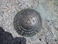
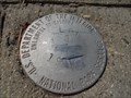 view gallery view gallerySW21.1 km |  LPL 3 - Sequoia National Park, CA LPL 3 - Sequoia National Park, CA
in U.S. Benchmarks Surprised to find this one on the sidewalk near parking at the Lodgepole area. posted by: sbcamper location: California date approved: 05/12/2015 last visited: never |
 view gallery view gallerySW21.1 km |  Lodgepole C G pump - Sequoia N P CA Lodgepole C G pump - Sequoia N P CA
in Hand Operated Water Pumps Found these in the tent camping area. Guess they are shut off
for the winter. They don't appear to be freeze style. posted by: sbcamper location: California date approved: 06/09/2015 last visited: never |
 view gallery view gallerySW21.1 km |  Sequoia National Park, California 93262 Sequoia National Park, California 93262
in U.S. Post Offices Located in the Lodgepole area of the park, this very nice post office is open for business. posted by: teeoff2 location: California date approved: 10/29/2008 last visited: 08/08/2018 |
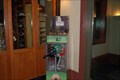
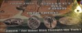 view gallery view gallerySW21.1 km |  Sequoia National Park - Lodgepole Market Penny Smasher Sequoia National Park - Lodgepole Market Penny Smasher
in Penny Smashers This four-design hand-cranked Penny Smasher is in the Lodgepole Market in Sequoia National Park, California. An admission fee is required to access this machine. posted by: brwhiz location: California date approved: 08/29/2012 last visited: 05/12/2015 |
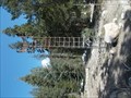 view gallery view gallerySW21.2 km |  Lodgepole NPS - Sequoia Nat'l Park - CA Lodgepole NPS - Sequoia Nat'l Park - CA
in Weather Stations Non automated station. posted by: sbcamper location: California date approved: 06/11/2015 last visited: never |
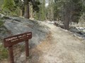
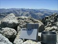 view gallery view gallery N21.6 km N21.6 km
|  Arrow Peak Arrow Peak
in Summit Registers Arrow Peak summit, elevation 12959 feet, located in Kings Canyon National Park. It is often photographed from Bench Lake, known for its mirror-like surface at dawn reflecting the image of the peak. posted by: atc location: California date approved: 01/28/2006 last visited: never |
 view gallery view gallerySW21.7 km | Wuksachi Village, Sequoia National Park in U.S. Benchmarks Dept of Interior Benchmark posted by: Daniel Nestlerode location: California date approved: 07/06/2008 last visited: 07/02/2014 |
 view gallery view gallerySW21.9 km |  Clover Creek - Sequoia Natl Park CA Clover Creek - Sequoia Natl Park CA
in Stone Bridges Two lanes along the Generals Highway between Lodgepole and Wuksachi Lodge. posted by: sbcamper location: California date approved: 07/05/2015 last visited: never |
 view gallery view gallerySW22 km | Wuksachi Bridge in Hiking Path Footbridges Hiking footpath bridge at Wuksachi Lodge in Sequoia National Park. posted by: dmbfan73 location: California date approved: 04/04/2011 last visited: 05/12/2015 |
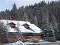
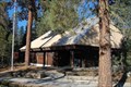
 view gallery view gallerySW22 km |  Wuksachi Lodge - Sequoia National Park, California Wuksachi Lodge - Sequoia National Park, California
in Lodge-Style Accommodations A wonderful mountain park resort lodge in Sequoia National Park. posted by: teeoff2 location: California date approved: 11/03/2008 last visited: 05/12/2015 |
 view gallery view gallerySW22 km | Wuksachi Lodge Smasher - Sequoia National Park, California in Penny Smashers This penny smasher is located in the lobby of the Wuksachi Lodge. posted by: teeoff2 location: California date approved: 11/03/2008 last visited: 05/12/2015 |
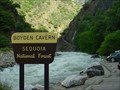 view gallery view galleryW23.2 km | ") Boyden Cavern, California Boyden Cavern, California
in Cave Entrances (Natural) Cave in Kings Canyon posted by: Bernd das Brot Team location: California date approved: 04/29/2008 last visited: never |
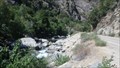 view gallery view galleryW23.2 km |  KINGS RIVER, CALIFORNIA KINGS RIVER, CALIFORNIA
in National Wild and Scenic Rivers KINGS RIVER is located in Kings Canyon National Park, CA posted by: tatie location: California date approved: 11/16/2013 last visited: 09/10/2017 |
 view gallery view gallerySW23.8 km | Dorst Creek - Sequoia Nat'l Park - CA in Campgrounds 218 sites. four group sites. reservations in summer. flush toilets. posted by: sbcamper location: California date approved: 05/21/2015 last visited: never |
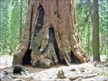
 view gallery view gallerySW23.8 km |  General Sherman Tree - Sequoia National Park, California General Sherman Tree - Sequoia National Park, California
in 'You Are Here' Maps The short hike to the General Sherman tree starts with this You are Here sign posted by: teeoff2 location: California date approved: 11/03/2008 last visited: 08/08/2018 |
 view gallery view gallerySW24.1 km | ") Sequoia National Park Sequoia National Park
in National Parks (U.S.) The world's largest trees posted by: Bernd das Brot Team location: California date approved: 05/17/2008 last visited: 07/31/2023 |
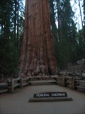 view gallery view gallerySW24.1 km |  General Sherman General Sherman
in Exceptional Trees The General Sherman Giant Sequoia is located in Sequuoia National park, California. posted by: Jagman714 location: California date approved: 12/12/2006 last visited: 07/31/2023 |
|