 view gallery view gallery SE17.5 km SE17.5 km
|   Mt. Whitney Mt. Whitney
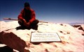
in Mountain Summits Mt Whitney is the highest point in the contiguous United States. posted by:  wilsonjw wilsonjw location: California date approved: 09/08/2005 last visited: 08/01/2013 |
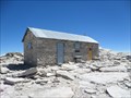 view gallery view gallerySE17.5 km |  Smithsonian Institution Shelter - Mt. Whitney, CA Smithsonian Institution Shelter - Mt. Whitney, CA
in U.S. National Register of Historic Places Mt. Whitney Smithsonian Research Facility
Sequoia National Park, CA posted by: fresgo location: California date approved: 08/06/2013 last visited: 08/05/2013 |
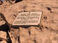
 view gallery view gallerySE17.5 km |  Highest Point in California (Mt Whitney) Highest Point in California (Mt Whitney)
in Geographic High Points Mt Whitney at 14,505 feet is the highest point in California, as well as the lower 48 states and both Tulare and Inyo counties. posted by: Rumpled location: California date approved: 10/20/2008 last visited: 08/04/2013 |
 view gallery view gallerySE17.5 km | Highest Point in Tulare County (Mt Whitney) in Geographic High Points Mt Whitney at 14,505 feet is the highest point in Tulare County, as well as the lower 48 states, the state of California and Inyo County. posted by: Rumpled location: California date approved: 10/20/2008 last visited: 08/04/2013 |
 view gallery view gallerySE17.5 km | Highest Point in Inyo County (Mt Whitney) in Geographic High Points Mt Whitney at 14,505 feet is the highest point in Inyo County, as well as the lower 48 states, the state of California and Tulare County.
posted by: Rumpled location: California date approved: 10/20/2008 last visited: 08/01/2013 |
 view gallery view gallery E22 km E22 km
|  Mt Williamson Sierra Nevada Mt Williamson Sierra Nevada
in Ansel Adams Photo Hunt Ansel Adams Mt Williamson Sierra Nevada photograph location posted by:  bdouglas bdouglas location: California date approved: 04/18/2006 last visited: 10/24/2010 |
 view gallery view gallery NE22.4 km NE22.4 km
|  Mount Whitney Fish Hatchery Guestbook - Independence, California Mount Whitney Fish Hatchery Guestbook - Independence, California
in Guest Books The guestbook for the historic Mount Whitney Fish Hatchery is located on the check out counter for the Gift Shop. posted by: Touchstone location: California date approved: 09/03/2009 last visited: 08/04/2012 |
 view gallery view galleryNE22.4 km |  Mount Whitney Fish Hatchery - Independence, California Mount Whitney Fish Hatchery - Independence, California
in E Clampus Vitus Historical Markers Located at the historic Mount Whitney Fish Hatchery, this plaque explains some of the history of how the hatchery came to be built. posted by: Touchstone location: California date approved: 09/02/2009 last visited: 02/12/2014 |
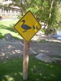 view gallery view galleryNE22.4 km |  Duck Crossing - Mount Whitney Fish Hatchery, Independence, California Duck Crossing - Mount Whitney Fish Hatchery, Independence, California
in Uncommon Crossing Signs A duck crossing sign to warn drivers accessing the historic fish hatchery. posted by: Touchstone location: California date approved: 09/02/2009 last visited: 08/04/2012 |
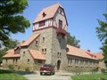 view gallery view galleryNE22.4 km |  Mount Whitney Fish Hatchery - Independence, California Mount Whitney Fish Hatchery - Independence, California
in Fish Hatcheries One of the oldest operating fish hatcheries in California, the historic building and brood ponds offer a relaxing place to picnic on any trip through the Owens Valley. posted by: Touchstone location: California date approved: 09/02/2009 last visited: 05/15/2014 |
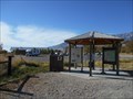 view gallery view gallery W22.5 km W22.5 km
|  Eastern Sierra Visitor Center, Inyo N. F. - Long Pine CA Eastern Sierra Visitor Center, Inyo N. F. - Long Pine CA
in Tourist Information Centers - Visitor Centers Thirteen of the peaks over 14,000 feet are in Inyo County. Permits are required for Wilderness access and trails.
There is a picnic area, bookstore and gift shop, area maps. posted by: sbcamper location: California date approved: 08/14/2022 last visited: never |
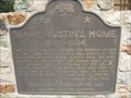 view gallery view galleryNE23.5 km |  Mary Austin's Home - CHL No. 229 Mary Austin's Home - CHL No. 229
in California Historical Markers The historical marker is located in front of a private home at 253 Market Street in Independence CA. posted by: The Fat Cats location: California date approved: 07/05/2015 last visited: 06/05/2017 |
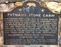 view gallery view galleryNE23.7 km | Putnam’s Stone Cabin in California Historical Markers Located along the Three Flags Highway (US 395) in Independence, CA. posted by: fresgo location: California date approved: 05/31/2011 last visited: never |
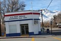 view gallery view galleryNE23.7 km |  INDEPENDENCE, CA 93526 INDEPENDENCE, CA 93526
in U.S. Post Offices This is one of the SMALL Post Offices posted by: Tissa1020 & Foxhound location: California date approved: 01/16/2009 last visited: 10/24/2018 |
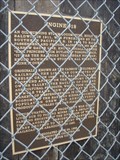 view gallery view galleryNE23.7 km | Engine #18 - Independence, CA in E Clampus Vitus Historical Markers This is a marker for the train known as the Slim Princess. The train and marker are at the north end of town in Dehy Park. posted by: Free2bme29 location: California date approved: 02/23/2009 last visited: 10/03/2015 |
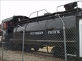 view gallery view galleryNE23.7 km |  Slim Princess #18 - Independence, CA Slim Princess #18 - Independence, CA
in Locomotives This is a Southern Pacific Narrow Gauge locomotive sitting in a park at the north end of Independence. posted by: Free2bme29 location: California date approved: 02/22/2009 last visited: 10/03/2015 |
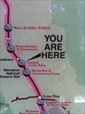 view gallery view galleryNE23.7 km |  Eastern Sierra Scenic Byway - Independence, CA Eastern Sierra Scenic Byway - Independence, CA
in 'You Are Here' Maps Dehy Park US 395 Independence, CA posted by: fresgo location: California date approved: 05/26/2011 last visited: 10/03/2015 |
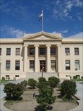 view gallery view galleryNE23.7 km |  Inyo County Courthouse Inyo County Courthouse
in Courthouses Located in Independence, CA on US Route 395. posted by: fresgo location: California date approved: 04/15/2011 last visited: 08/03/2012 |
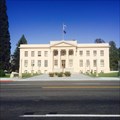 view gallery view galleryNE23.7 km | Inyo County Courthouse - Independence, CA in U.S. National Register of Historic Places The Inyo County Courthouse in Independence. posted by: saopaulo1 location: California date approved: 05/07/2016 last visited: 05/13/2021 |
 view gallery view galleryNE23.7 km |  Inyo County Courthouse - Independence, CA Inyo County Courthouse - Independence, CA
in Wikipedia Entries The Inyo County Courthouse in Independence. posted by: saopaulo1 location: California date approved: 05/04/2016 last visited: 05/13/2021 |
 view gallery view galleryNE23.7 km | Inyo County Courthouse - Independence, CA in Bookcrossing Zones A bookcrossing zone at the Inyo County Courthouse in Independence. posted by: saopaulo1 location: California date approved: 05/03/2016 last visited: 05/13/2021 |
 view gallery view galleryNE23.7 km |  Inyo County Courthouse - Independence, CA Inyo County Courthouse - Independence, CA
in Satellite Imagery Oddities The courthouse in Inyo County and the county seat of Independence. posted by: saopaulo1 location: California date approved: 05/03/2016 last visited: 05/13/2021 |
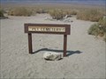 view gallery view galleryE23.8 km |  Manzanar Pet Cemetery Manzanar Pet Cemetery
in Pet Cemeteries The Manzanar Pet Cemetery is located just outside the barbed wire enclosure of the internment camp, adjacent to the famous Obelisk that marks the Manzanar Cemetery. posted by: Touchstone location: California date approved: 09/03/2009 last visited: 05/13/2021 |
 view gallery view galleryE23.8 km | Manzanar Cemetery in Ansel Adams Photo Hunt Ansel Adams visited the Manzanar War Relocation Camp in 1943 and took over 200 images of the camp during his visit. The original glass plates are housed in the Library of Congress. posted by: Touchstone location: California date approved: 09/01/2009 last visited: 03/04/2022 |
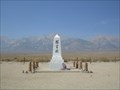 view gallery view galleryE23.8 km |  Manzanar Cemetery - Independence, California Manzanar Cemetery - Independence, California
in Obelisks This 15 foot obelisk stands in the center of the Manzanar Cemetery on the Western edge of the Internment Camp. posted by: Touchstone location: California date approved: 09/01/2009 last visited: 03/04/2022 |
|