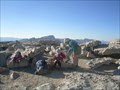
 view gallery view gallery S3.2 km S3.2 km
|   Golden Trout Wilderness, Horshoe Meadow Trailhead - California Golden Trout Wilderness, Horshoe Meadow Trailhead - California
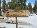
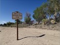
in Hiking and walking trailheads Horseshoe Meadow Trailhead offers a relatively easy access point to Golden Trout Wilderness, but also the Southern portion of John Muir Wilderness. posted by:  Touchstone Touchstone location: California date approved: 09/02/2009 last visited: never |
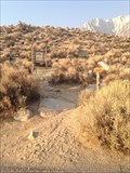
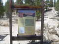 view gallery view galleryS3.2 km |  Horshoe Meadow Trailhead - Lone Pine, California Horshoe Meadow Trailhead - Lone Pine, California
in 'You Are Here' Maps A large map at the Horshoe Meadow Trailhead that gives would-be backpackers and hikers some idea of where they are. posted by: Touchstone location: California date approved: 09/02/2009 last visited: never |
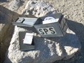
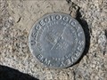 view gallery view galleryS6.3 km |  Trail Peak Benchmark Trail Peak Benchmark
in U.S. Benchmarks U. S. Geological Survey Benchmark at summit of Trail Peak in Golden Trout Wilderness of Inyo National Forest. posted by: CoachDave45 location: California date approved: 08/11/2010 last visited: never |
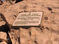
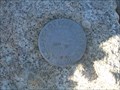 view gallery view gallery NW7.2 km NW7.2 km
| Mount Langley - California in U.S. Benchmarks A benchmark located on the summit of Mount Langley in the Sierra mountain range of California. posted by: Touchstone location: California date approved: 09/01/2009 last visited: 09/07/2016 |
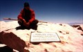
 view gallery view galleryNW7.2 km |  Mount Langley Mount Langley
in Mountain Summits The lowest of the 14'ers in California, as well as technically the easiest to reach and ascend. posted by: Touchstone location: California date approved: 08/31/2009 last visited: never |
 view gallery view galleryNW7.2 km |  Mount Langley - California Mount Langley - California
in Summit Registers Located on the summit of Mount Langley (14,022 feet) in the Southern Sierra of California. posted by: Touchstone location: California date approved: 08/30/2009 last visited: never |
 view gallery view gallery N12.9 km N12.9 km
| Whitney Portal National Recreation Trail in Hiking and walking trailheads Lone Pine Campground, Inyo National Forest. The trail head is at the west end of the campground. Parking is available in the Day Use Area. posted by: fresgo location: California date approved: 08/11/2013 last visited: never |
 view gallery view galleryNW15 km |  Highest Point in California (Mt Whitney) Highest Point in California (Mt Whitney)
in Geographic High Points Mt Whitney at 14,505 feet is the highest point in California, as well as the lower 48 states and both Tulare and Inyo counties. posted by: Rumpled location: California date approved: 10/20/2008 last visited: 08/04/2013 |
 view gallery view galleryNW15 km | Highest Point in Tulare County (Mt Whitney) in Geographic High Points Mt Whitney at 14,505 feet is the highest point in Tulare County, as well as the lower 48 states, the state of California and Inyo County. posted by: Rumpled location: California date approved: 10/20/2008 last visited: 08/04/2013 |
 view gallery view galleryNW15 km | Highest Point in Inyo County (Mt Whitney) in Geographic High Points Mt Whitney at 14,505 feet is the highest point in Inyo County, as well as the lower 48 states, the state of California and Tulare County.
posted by: Rumpled location: California date approved: 10/20/2008 last visited: 08/01/2013 |
 view gallery view galleryNW15 km | Mt. Whitney in Mountain Summits Mt Whitney is the highest point in the contiguous United States. posted by: wilsonjw location: California date approved: 09/08/2005 last visited: 08/01/2013 |
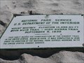
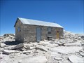 view gallery view galleryNW15 km |  Smithsonian Institution Shelter - Mt. Whitney, CA Smithsonian Institution Shelter - Mt. Whitney, CA
in U.S. National Register of Historic Places Mt. Whitney Smithsonian Research Facility
Sequoia National Park, CA posted by: fresgo location: California date approved: 08/06/2013 last visited: 08/05/2013 |
 view gallery view gallery SE15 km SE15 km
|  Cottonwood Charcoal Kilns Cottonwood Charcoal Kilns
in E Clampus Vitus Historical Markers This ECV marker is just off Highway 395 near Owens Lake. posted by: Free2bme29 location: California date approved: 07/06/2009 last visited: 04/03/2011 |
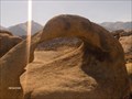 view gallery view galleryN15.3 km |  Whitney Arch, Alabama Hills Whitney Arch, Alabama Hills
in Natural Arches This is the famous arch on the postcards that you can see Mt Whitney through. Also called mobius arch, due to it's twisting shape. posted by: Rumpled location: California date approved: 10/20/2008 last visited: 08/16/2012 |
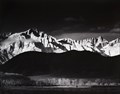 view gallery view gallery NE16.3 km NE16.3 km
|  Ansel Adams - Winter Sunrise of Mt Whitney from Lone Pine, CA Ansel Adams - Winter Sunrise of Mt Whitney from Lone Pine, CA
in Ansel Adams Photo Hunt Ansel Adams - Winter Sunrise of Mt Whitney from Lone Pine, CA posted by:  05auditt 05auditt location: California date approved: 06/11/2013 last visited: 07/21/2014 |
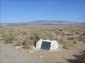
 view gallery view gallerySE16.4 km |  NO. 537 COTTONWOOD CHARCOAL KILNS NO. 537 COTTONWOOD CHARCOAL KILNS
in California Historical Markers COTTONWOOD CHARCOAL KILNS
posted by: GeoCraig location: California date approved: 09/08/2007 last visited: 04/03/2011 |
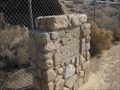
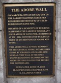 view gallery view galleryNE17.1 km | The Adobe Wall in E Clampus Vitus Historical Markers This E Clampus Vitus Historical Marker is located in Lone Pine, CA. posted by: Team Min Dawg location: California date approved: 07/24/2009 last visited: 03/28/2014 |
 view gallery view galleryNE17.2 km |  Lone Pine, California 93545 Lone Pine, California 93545
in U.S. Post Offices This Post Office is located at 121 E Bush Street in Lone Pine, California. posted by: brwhiz location: California date approved: 02/03/2013 last visited: 10/24/2018 |
 view gallery view galleryNE17.5 km |  Southern Inyo Hospital - Lone Pine, CA Southern Inyo Hospital - Lone Pine, CA
in Hospitals This little hospital is located in Lone Pine. I'm guessing the hospital sees lots of cases related to hiking and fishing! posted by: Free2bme29 location: California date approved: 07/06/2009 last visited: 02/08/2014 |
 view gallery view galleryNE18 km |  1872 Earthquake Victims Cemetery- Lone Pine, California, USA 1872 Earthquake Victims Cemetery- Lone Pine, California, USA
in Abandoned Cemeteries North of Lone Pine on Rt 395 is the mass grave site for the victims of the March 26, 1872 earthquake that destroyed the town. The earthquake struck at 2:10am. 27 people in Lone Pine were killed during the quake. posted by: calgriz location: California date approved: 09/09/2014 last visited: 05/13/2021 |
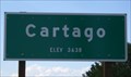 view gallery view gallerySE22.5 km |  Cartago, CA - 3638 Feet Cartago, CA - 3638 Feet
in Elevation Signs Spotted this sign while driving on highway 395, somewhere north of Ridgecrest. posted by: Free2bme29 location: California date approved: 07/06/2009 last visited: 03/18/2014 |
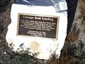 view gallery view gallerySE22.7 km | Cartago Boat Landing in E Clampus Vitus Historical Markers In Cartago alongside the highway. posted by: fresgo location: California date approved: 05/24/2011 last visited: 05/23/2011 |
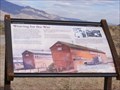 view gallery view galleryN26.9 km |  Weaving for the War (Manzanar National Historic Site)-Independence, CA Weaving for the War (Manzanar National Historic Site)-Independence, CA
in Signs of History America went to work for the war effort in 1942, and Manzanar was no exception. More than 500 young Japanese Americans wove camouflage nets here for the U.S. Army. posted by: Don.Morfe location: California date approved: 11/28/2019 last visited: 09/28/2021 |
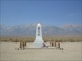 view gallery view galleryN27 km |  Manzanar Cemetery - Independence, California Manzanar Cemetery - Independence, California
in Obelisks This 15 foot obelisk stands in the center of the Manzanar Cemetery on the Western edge of the Internment Camp. posted by: Touchstone location: California date approved: 09/01/2009 last visited: 03/04/2022 |
 view gallery view galleryN27 km | Manzanar Cemetery in Ansel Adams Photo Hunt Ansel Adams visited the Manzanar War Relocation Camp in 1943 and took over 200 images of the camp during his visit. The original glass plates are housed in the Library of Congress. posted by: Touchstone location: California date approved: 09/01/2009 last visited: 03/04/2022 |
|