 view gallery view gallery NW3.5 km NW3.5 km
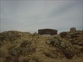
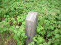
|   Eric's Bench, Garrapata State Park, Big Sur, Ca Eric's Bench, Garrapata State Park, Big Sur, Ca
in Scenic Overlooks A panaoramic view of the Pacific Ocean in Big Sur posted by:  WalruZ WalruZ location: California date approved: 10/02/2006 last visited: 03/28/2007 |
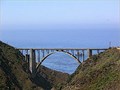
 view gallery view gallery S6.6 km S6.6 km
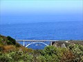
|  Rocky Creek Bridge - Route 1 - Big Sur, CA Rocky Creek Bridge - Route 1 - Big Sur, CA
in National Scenic Byways One of a few famous bridges along Pacific Coast Highway. posted by: bluesnote location: California date approved: 04/22/2016 last visited: 04/22/2016 |
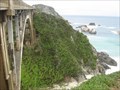
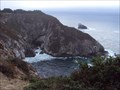
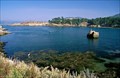
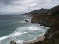 view gallery view galleryS6.6 km | Rocky Creek - Big Sur, CA in Scenic Overlooks Next to the Rocky Creek Bridge, this view has two spectacles. The Pacific, and the bridge. posted by: bluesnote location: California date approved: 04/22/2016 last visited: 04/22/2016 |
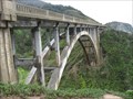 view gallery view galleryS6.6 km |  Rocky Creek Bridge - Big Sur, CA Rocky Creek Bridge - Big Sur, CA
in Wikipedia Entries One of a few famous bridges along Pacific Coast Highway. posted by: bluesnote location: California date approved: 04/22/2016 last visited: 04/22/2016 |
 view gallery view galleryS6.6 km |  The Pacific Coast Highway and Big Sur - Big Sur, CA The Pacific Coast Highway and Big Sur - Big Sur, CA
in 1000 Places to See Before You Die The most famous stretch of PCH is located just south of Monterey in Big Sur. The above coordinates are for Rocky Creek Bridge, one of several historic bridges of PCH. posted by: bluesnote location: California date approved: 07/24/2020 last visited: 10/15/2021 |
 view gallery view galleryS6.6 km |  Rocky Creek Bridge - Big Sur, California Rocky Creek Bridge - Big Sur, California
in Arch Bridges Almost a twin in design to the slightly larger Bixby Creek Bridge posted by: hotshoe location: California date approved: 09/22/2008 last visited: 10/07/2016 |
 view gallery view galleryS6.9 km | ") Hwy 1 Seacave - Monteray County - California Hwy 1 Seacave - Monteray County - California
in Cave Entrances (Natural) This Sea Cave was spotted from an overlook on Highway 1 posted by:  GT.US GT.US location: California date approved: 10/18/2010 last visited: never |
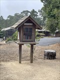 view gallery view galleryNW6.9 km |  LFL 9359 - Carmel, CA LFL 9359 - Carmel, CA
in Free Community Book Exchanges A little free library in Carmel. posted by: saopaulo1 location: California date approved: 03/16/2022 last visited: never |
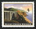 view gallery view galleryS7.2 km |  Bixby Creek Bridge, Monterey County, California Bixby Creek Bridge, Monterey County, California
in Philatelic Photographs Bixby Creek bridge spans Bixby canyon on California route 1 about 13 miles south of Carmel in California's Big Sur region. posted by: hykesj location: California date approved: 07/08/2012 last visited: 08/13/2018 |
 view gallery view galleryS7.2 km | Bixby Creek Bridge - Big Sur, California in Arch Bridges The most photographed bridge on Hwy 1 along the California coast posted by: hotshoe location: California date approved: 09/22/2008 last visited: 08/13/2018 |
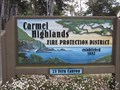 view gallery view galleryNW8.2 km |  Carmel Highlands Fire Protection District - Carmel, CA Carmel Highlands Fire Protection District - Carmel, CA
in Firehouses The Carmel Highlands Fire Department is located on Fern Canyon Road in Carmel-By-The-Sea, California. posted by: DougK location: California date approved: 09/30/2009 last visited: never |
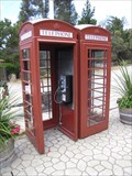 view gallery view galleryNW8.2 km |  Red Phone Booth Pair - Carmel Highlands, CA Red Phone Booth Pair - Carmel Highlands, CA
in Red Telephone Boxes There's a pair of phone booths at a gas station in Carmel Highlands, CA. posted by: DougK location: California date approved: 06/21/2009 last visited: never |
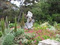 view gallery view galleryNW8.2 km |  Gravity Garden - Carmel Highlands, CA Gravity Garden - Carmel Highlands, CA
in Official Local Tourism Attractions Jim Needham is a different kind of rock artist. His Gravity Garden is a sculpture garden made from stacked rocks. posted by: DougK location: California date approved: 06/21/2009 last visited: never |
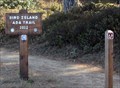 view gallery view galleryNW8.9 km |  Bird Island Trail, Carmel, CA Bird Island Trail, Carmel, CA
in Accessible-Designed Recreational Locations This is a wheelchair accessible trail. posted by: Queens Blessing location: California date approved: 11/26/2013 last visited: never |
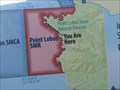 view gallery view galleryNW8.9 km |  Point Lobos State Natural Reserve, Carmel, CA Point Lobos State Natural Reserve, Carmel, CA
in 'You Are Here' Maps This map shows your current location, at a most beautiful location in Point Lobos State Park. posted by: Queens Blessing location: California date approved: 11/23/2013 last visited: never |
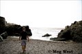 view gallery view galleryNW9 km |  Hidden Beach Proposal - Point Lobos, Carmel, CA Hidden Beach Proposal - Point Lobos, Carmel, CA
in 'Marry Me' Markers Jeff proposed to me towards the end of our first trip to Point Lobos. I thought for sure that he would propose later in the evening, at our favorite restaurant. But something told him to propose to me here! posted by: heymego location: California date approved: 08/01/2009 last visited: 09/30/2013 |
 view gallery view gallery N9.3 km N9.3 km
|  Point Lobos - California, USA Point Lobos - California, USA
in Olmsted Designed Parks Frederick Law Olmsted helped designing and creating today's Point Lobos State Natural Reserve. posted by: netdust location: California date approved: 06/03/2015 last visited: never |
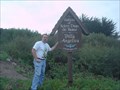
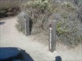
 view gallery view galleryN9.3 km |  South Plateau Trail Guide - Point Lobos State Natural Reserve, California South Plateau Trail Guide - Point Lobos State Natural Reserve, California
in Self Guided Walks and Trails A one mile nature trail in the scenic Point Lobos State Natural Reserve near Monterey, California posted by: Touchstone location: California date approved: 12/22/2008 last visited: 11/07/2008 |
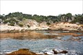
 view gallery view galleryN9.8 km |  Whalers Cove, California Whalers Cove, California
in Dive Sites America's first underwater reserve posted by: Bernd das Brot Team location: California date approved: 12/11/2006 last visited: 09/30/2013 |
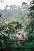
 view gallery view galleryN9.8 km |  Shack and Trees, Point Lobos, California Shack and Trees, Point Lobos, California
in Ansel Adams Photo Hunt Located on the Point Lobos State Preserve. posted by: Touchstone location: California date approved: 11/17/2008 last visited: 09/30/2013 |
 view gallery view galleryN9.8 km |  Sisters of Notre Dame de Namur Sisters of Notre Dame de Namur
in Abbeys, Convents and Monasteries The coordinates above will bring you to the gate of the Carmelite Monastery of the Sister of Notre Dame de Namur. posted by: Touchstone location: California date approved: 09/14/2005 last visited: 09/30/2006 |
 view gallery view galleryNW10 km |  Point Lobos State Preserve Point Lobos State Preserve
in U.S. National Natural Landmarks A magnificent interaction of land, sea, wildlife and vegetation. posted by: Bernd das Brot Team location: California date approved: 05/31/2006 last visited: 09/30/2013 |
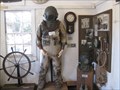 view gallery view galleryNW10.1 km |  Whaler's Cabin Museum, Point Lobos, CA Whaler's Cabin Museum, Point Lobos, CA
in Maritime Museums This museum is in a former Whaling Station building. posted by: Queens Blessing location: California date approved: 11/23/2013 last visited: never |
 view gallery view galleryNW10.1 km |  Whalers Cove, Point Lobos State Reserve, California Whalers Cove, Point Lobos State Reserve, California
in Bicycle Tenders These bike tenders remind me more of someplace you might tether up your horse. posted by: Touchstone location: California date approved: 11/21/2008 last visited: 09/30/2013 |
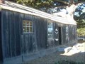 view gallery view galleryNW10.1 km |  Whalers Cabin - Point Lobos State Reserve, California Whalers Cabin - Point Lobos State Reserve, California
in U.S. National Register of Historic Places Located in Point Lobos State Reserve, this once a whalers cabin now serves as a museum and information center for the Park. posted by: Touchstone location: California date approved: 11/17/2008 last visited: 09/30/2013 |
|