 view gallery view gallery N13.8 km N13.8 km
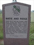
|   Watie and Ridge - S. of Grove, OK Watie and Ridge - S. of Grove, OK
in Civil Rights Memorials Confederate war heroes, and Cherokees who spoke their mind. Fought in the Civil War for the Confederacy, because the Union drove them from their homes. posted by:  YoSam. YoSam. location: Oklahoma date approved: 03/18/2023 last visited: 10/21/2023 |
 view gallery view galleryN13.8 km |  Watie and Ridge - S. of Grove, OK Watie and Ridge - S. of Grove, OK
in Oklahoma Historical Markers Confederate war heroes, and Cherokees who spoke their mind. posted by: YoSam. location: Oklahoma date approved: 11/24/2018 last visited: 10/21/2023 |
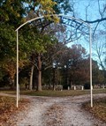 view gallery view galleryN14.8 km |  Butler Cemetery - Grove, OK Butler Cemetery - Grove, OK
in Worldwide Cemeteries Butler Cemetery is a few miles east of Grove, Oklahoma. posted by: The Snowdog location: Oklahoma date approved: 10/21/2023 last visited: never |
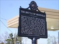
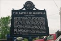 view gallery view gallery E16.4 km E16.4 km
|  The Battle of Maysville - Maysville, AR The Battle of Maysville - Maysville, AR
in Battlefields A second conflict in the area of Pea Ridge, months after the major battle posted by: YoSam. location: Arkansas date approved: 06/14/2023 last visited: never |
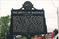 view gallery view galleryE16.4 km |  The Battle of Maysville - Maysville, AR The Battle of Maysville - Maysville, AR
in American Civil War Monuments and Memorials A second conflict in the area of Pea Ridge, months after the major battle posted by: YoSam. location: Arkansas date approved: 01/08/2015 last visited: never |
 view gallery view galleryE16.4 km |  The Battle of Maysville The Battle of Maysville
in Arkansas Historical Markers A country drive will net you another Arkansas Historical Marker Waymark. posted by:  *TnT* *TnT* location: Arkansas date approved: 04/28/2007 last visited: 05/15/2007 |
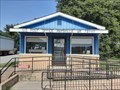 view gallery view galleryE16.4 km |  Maysville, AR 72747 Maysville, AR 72747
in U.S. Post Offices A small post office in a small town; Maysville, Arkansas posted by: The Snowdog location: Arkansas date approved: 07/18/2020 last visited: never |
 view gallery view gallery NW16.4 km NW16.4 km
|  Do A Handstand - Jay, OK Do A Handstand - Jay, OK
in Photo Goals Photograph a friend (or have them photograph you) doing a handstand! posted by: The Snowdog location: Oklahoma date approved: 10/15/2022 last visited: 07/11/2023 |
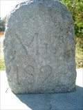 view gallery view gallery NE17.5 km NE17.5 km
|  BONDARY MONUMENT MO ARK OK BONDARY MONUMENT MO ARK OK
in U.S. Historic Survey Stones and Monuments ANOTHER TRI STATE BOUNDARY STONE.
MISSOURI ARKANSAS AND OKLAHOMA.
posted by: GEO*Trailblazer 1 location: Missouri date approved: 10/29/2006 last visited: 07/17/2020 |
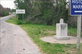
 view gallery view galleryNE17.5 km |  Oklahoma - Missouri - Arkansas Tripoint Oklahoma - Missouri - Arkansas Tripoint
in Tripoints and Multipoints This marker designates the point where the U.S. states of Oklahoma, Arkansas and Missouri meet. posted by: silverquill location: Oklahoma date approved: 04/22/2013 last visited: 07/17/2020 |
 view gallery view galleryNE17.5 km |  BORDER CROSSING MO AR OK BORDER CROSSING MO AR OK
in Border Crossings This Monument marks the SW corner of Missouri The NE corner of Oklahoma and the NW corner of Arkansas posted by: GEO*Trailblazer 1 location: Missouri date approved: 12/02/2007 last visited: 07/17/2020 |
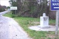
 view gallery view galleryNE17.5 km |  Tri-State Boundary Marker - Southwest City, MO Tri-State Boundary Marker - Southwest City, MO
in Lions Clubs International Markers Actually the state is Arkansas - Missouri - & Oklahoma since it sits on the point where all three meet. posted by: YoSam. location: Missouri date approved: 01/15/2015 last visited: 07/17/2020 |
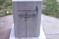
 view gallery view galleryNE17.5 km |  Tri-State Identification Marker - 1915 & 1955 - Southwest City, MO & AR & OK Tri-State Identification Marker - 1915 & 1955 - Southwest City, MO & AR & OK
in Dated Architectural Structures Multifarious Original marker, the upgraded, then improved again, without removing the old...point where Arkansas, Missouri and Oklahoma meet. posted by: YoSam. location: Arkansas date approved: 04/14/2019 last visited: 07/17/2020 |
 view gallery view galleryNE17.5 km |  Border Stone - Tri-State ~ MO, OK, AR Border Stone - Tri-State ~ MO, OK, AR
in Public Land Survey Marks Just S. of Southwest City in Missouri. posted by: YoSam. location: Missouri date approved: 11/11/2009 last visited: 07/17/2020 |
 view gallery view galleryNE17.5 km | Tri-State Monument - Delaware County, OK in Oklahoma Historical Markers Where three states meet, southern limits of Southwest City, MO and northwest of Maryville, AR. posted by: YoSam. location: Oklahoma date approved: 11/06/2008 last visited: 07/17/2020 |
 view gallery view galleryNE17.5 km |  OKARMO Corner OKARMO Corner
in Wikipedia Entries Original marker, the upgraded, then improved again, without removing the old...point where Arkansas, Missouri and Oklahoma meet. posted by: YoSam. location: Arkansas date approved: 04/14/2019 last visited: 07/17/2020 |
 view gallery view galleryNE17.5 km |  Tri-State Marker - Southwest City, MO and AR and OK Tri-State Marker - Southwest City, MO and AR and OK
in Roadside Attractions Original marker, the upgraded, then improved again, without removing the old...point where Arkansas, Missouri and Oklahoma meet. posted by: YoSam. location: Arkansas date approved: 04/14/2019 last visited: 07/17/2020 |
 view gallery view galleryNE17.5 km |  Tri-State Marker - Southwest City, MO Tri-State Marker - Southwest City, MO
in Missouri Historical Markers The exact spot where three states meet and the western end to the Mason-Dixon Line. posted by: YoSam. location: Missouri date approved: 11/06/2008 last visited: 07/17/2020 |
 view gallery view galleryNE17.5 km | Tr-State Marker - Benton County, AR in Arkansas Historical Markers The point where three states meet, NW of Maysville, AR. posted by: YoSam. location: Arkansas date approved: 11/08/2008 last visited: 07/17/2020 |
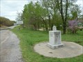
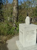
 view gallery view galleryNE18 km |  General Stand Watie, near Southwest City,(MO) in Oklahoma General Stand Watie, near Southwest City,(MO) in Oklahoma
in Specific Veteran Memorials On the shoulder of the road in front of Polson Cemetery, where Watie's grave is located. Only Native People to achieve the rank of Brigadier General during Civil War, and last Confederate General to surrender. posted by: YoSam. location: Oklahoma date approved: 08/19/2008 last visited: 10/21/2023 |
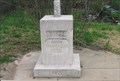
 view gallery view galleryNE18 km |  ONLY - Native American to Attain Rank of General & LAST - to Surrender - Delaware County, OK ONLY - Native American to Attain Rank of General & LAST - to Surrender - Delaware County, OK
in Superlatives There are two marker here. One by Oklahoma Historical Society, and one by United Daughters of the Confederacy. Both have the same superlative, and I combine them as one, since they stand together. posted by: YoSam. location: Oklahoma date approved: 12/11/2021 last visited: 10/21/2023 |
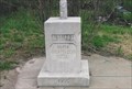
 view gallery view galleryNE18 km | Stand Watie - DEGATAGA OO-WATEE in Oklahoma Historical Markers Only Native to achieve General and last Confederate General to surrender. posted by: YoSam. location: Oklahoma date approved: 10/14/2008 last visited: 10/21/2023 |
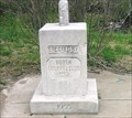
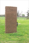
![Image for Stand Watie - [Degataga OO-Watiee] - NE of Jay, OK](https://img.geocaching.com/waymarking/small/d6d4db52-4a80-47a8-921c-d7b744d9ffcb.jpg) view gallery view galleryNE18 km |  Stand Watie - [Degataga OO-Watiee] - NE of Jay, OK Stand Watie - [Degataga OO-Watiee] - NE of Jay, OK
in Citizen Memorials Dark Red marble monument in front of the Polson Cemetery in Delaware County, OK. posted by: YoSam. location: Oklahoma date approved: 11/21/2018 last visited: 10/21/2023 |
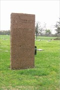
![Image for Stand Watie - [Degataga OO-Watiee] - NE of Jay, OK](https://img.geocaching.com/waymarking/small/13cb2629-818a-4ee2-83c0-30de54470c75.jpg) view gallery view galleryNE18 km | Stand Watie - [Degataga OO-Watiee] - NE of Jay, OK in Civil Rights Memorials There are two stone markers here about Mr. Watie. One military, one civilian in origin. I will combine them as one waymark since they are at the same site. posted by: YoSam. location: Oklahoma date approved: 03/23/2023 last visited: 10/21/2023 |
 view gallery view galleryNE18 km | Polson Cemetery Flagpole - rural Delaware County, Ok. in Citizen Memorials This flagpole, dedicated to several members of the Polson family, is located to the left of the entrance to the cemetery as one faces the entrance. The cemetery is located along East 340 Road in rural Delaware County west of Southwest City, Mo. posted by: iconions location: Oklahoma date approved: 11/16/2015 last visited: 10/21/2023 |
|