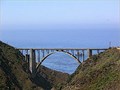
 view gallery view gallery NE0.2 km NE0.2 km
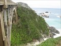
|   Bixby Creek Bridge - Big Sur, California Bixby Creek Bridge - Big Sur, California
in Arch Bridges The most photographed bridge on Hwy 1 along the California coast posted by:  hotshoe hotshoe location: California date approved: 09/22/2008 last visited: 08/13/2018 |
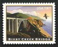 view gallery view gallery N0.2 km N0.2 km
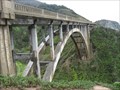
|  Bixby Creek Bridge, Monterey County, California Bixby Creek Bridge, Monterey County, California
in Philatelic Photographs Bixby Creek bridge spans Bixby canyon on California route 1 about 13 miles south of Carmel in California's Big Sur region. posted by: hykesj location: California date approved: 07/08/2012 last visited: 08/13/2018 |
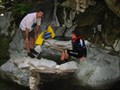
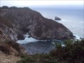 view gallery view galleryN0.5 km | ") Hwy 1 Seacave - Monteray County - California Hwy 1 Seacave - Monteray County - California
in Cave Entrances (Natural) This Sea Cave was spotted from an overlook on Highway 1 posted by:  GT.US GT.US location: California date approved: 10/18/2010 last visited: never |
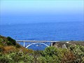 view gallery view galleryN0.8 km | Rocky Creek Bridge - Big Sur, California in Arch Bridges Almost a twin in design to the slightly larger Bixby Creek Bridge posted by: hotshoe location: California date approved: 09/22/2008 last visited: 10/07/2016 |
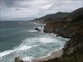
 view gallery view galleryN0.8 km |  The Pacific Coast Highway and Big Sur - Big Sur, CA The Pacific Coast Highway and Big Sur - Big Sur, CA
in 1000 Places to See Before You Die The most famous stretch of PCH is located just south of Monterey in Big Sur. The above coordinates are for Rocky Creek Bridge, one of several historic bridges of PCH. posted by: bluesnote location: California date approved: 07/24/2020 last visited: 10/15/2021 |
 view gallery view galleryN0.8 km |  Rocky Creek Bridge - Route 1 - Big Sur, CA Rocky Creek Bridge - Route 1 - Big Sur, CA
in National Scenic Byways One of a few famous bridges along Pacific Coast Highway. posted by: bluesnote location: California date approved: 04/22/2016 last visited: 04/22/2016 |
 view gallery view galleryN0.8 km |  Rocky Creek Bridge - Big Sur, CA Rocky Creek Bridge - Big Sur, CA
in Wikipedia Entries One of a few famous bridges along Pacific Coast Highway. posted by: bluesnote location: California date approved: 04/22/2016 last visited: 04/22/2016 |
 view gallery view galleryN0.8 km |  Rocky Creek - Big Sur, CA Rocky Creek - Big Sur, CA
in Scenic Overlooks Next to the Rocky Creek Bridge, this view has two spectacles. The Pacific, and the bridge. posted by: bluesnote location: California date approved: 04/22/2016 last visited: 04/22/2016 |
 view gallery view gallery SE5.8 km SE5.8 km
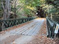
|  Coast Road, North Fork of the Little Sur River - Monterey County, California Coast Road, North Fork of the Little Sur River - Monterey County, California
in Bailey Bridges This Bailey Bridge crosses the North Fork of the Little Sur River on the Coast Road about 5.7 miles SE of the Bixby Bridge California Highway 1. posted by: DougK location: California date approved: 10/04/2010 last visited: never |
 view gallery view gallerySE7.1 km |  Tantalus Hotsprings Tantalus Hotsprings
in Hot Springs A small unimproved hotsprings along the Little Sur River. Hard to get to, but nice to soak in. posted by: Touchstone location: California date approved: 06/24/2006 last visited: never |
 view gallery view gallery S7.2 km S7.2 km
|  Point Sur Water Tower Point Sur Water Tower
in Disguised Cell Towers When a well known wireless company asked the Point Sur State History Park for permission to build a tower, the answer was "Yes, but only if it blends in..." posted by: Bernd das Brot Team location: California date approved: 05/26/2006 last visited: 02/02/2019 |
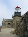 view gallery view galleryS7.2 km |  Point Sur Lightstation, California Point Sur Lightstation, California
in Coastal Lighthouses Point Sur, California posted by: GeoCraig location: California date approved: 09/26/2005 last visited: 11/18/2018 |
 view gallery view galleryS7.2 km |  POINT SUR LIGHT STATION POINT SUR LIGHT STATION
in California Historical Markers POINT SUR LIGHT STATION posted by: GeoCraig location: California date approved: 12/05/2005 last visited: 11/18/2018 |
 view gallery view galleryS7.4 km |  Lighthouse - KI6PAU Lighthouse - KI6PAU
in Amateur Radio Repeaters Repeater at Point Sur Lighthouse posted by: toponym location: California date approved: 12/23/2018 last visited: never |
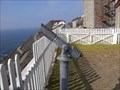 view gallery view galleryS7.4 km |  Point Sur Lighthouse Monocular Point Sur Lighthouse Monocular
in Coin-Op Binoculars Free monocular at the Point Sur Lighthouse posted by: toponym location: California date approved: 11/24/2018 last visited: never |
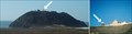
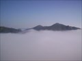 view gallery view gallerySE10 km |  Pico Blanco Pico Blanco
in Mountain Summits Considered a sacred peak by the Esselen Tribe, Pico Blanco stands like a sentinel over the Big Sur coastline. The climb to the summit is a hefty 3,500 feet of elevation gain, but the views from the top make it all worthwhile. posted by: Touchstone location: California date approved: 11/03/2005 last visited: never |
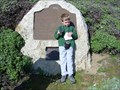
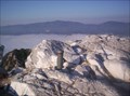 view gallery view gallerySE10 km |  Pico Blanco Register Pico Blanco Register
in Summit Registers The summit register atop Pinco Blanco was placed by the nearby Pico Blanco Boy Scout Camp. Apparently, the Scout Camp runs hikes to the summit during the middle of the night. Sounds like quite the adventure, but you may want to do it during the day. posted by: Touchstone location: California date approved: 11/03/2005 last visited: never |
 view gallery view galleryN10.6 km | Eric's Bench, Garrapata State Park, Big Sur, Ca in Scenic Overlooks A panaoramic view of the Pacific Ocean in Big Sur posted by: WalruZ location: California date approved: 10/02/2006 last visited: 03/28/2007 |
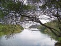 view gallery view galleryS10.8 km |  DESTINATION - Big Sur River DESTINATION - Big Sur River
in River Origins, Destinations and Confluences N 36° 14.215 W 121° 46.211 posted by: Bernd das Brot Team location: California date approved: 01/16/2007 last visited: never |
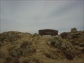
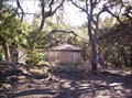 view gallery view gallerySE10.8 km |  Andrew Molera Water Tower Andrew Molera Water Tower
in Octagon Buildings Found this interesting shaped water tower on my way up the East Molera Trail to place a cache. posted by: Touchstone location: California date approved: 12/03/2005 last visited: 11/17/2018 |
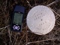 view gallery view gallerySE10.8 km |  Andrew Molera S.P.: AM-8 Andrew Molera S.P.: AM-8
in U.S. Benchmarks Found this disk placed by the California Department of Parks and Recreation. posted by: Touchstone location: California date approved: 12/03/2005 last visited: never |
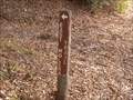 view gallery view gallerySE10.9 km |  East Molera Trail East Molera Trail
in Hiking and walking trailheads Short* trail heading inland from Molera State Beach posted by: toponym location: California date approved: 12/01/2018 last visited: never |
 view gallery view gallerySE11.1 km |  Andrew Molera State Park Water Tower Andrew Molera State Park Water Tower
in Water Towers This interesting water tower was built in 2004 to supply water to the park housing and campsite of the Andrew Molera State Park along the scenic Big Sur coast. posted by: Touchstone location: California date approved: 12/03/2005 last visited: 11/17/2018 |
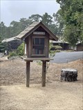 view gallery view galleryN13.8 km |  LFL 9359 - Carmel, CA LFL 9359 - Carmel, CA
in Free Community Book Exchanges A little free library in Carmel. posted by: saopaulo1 location: California date approved: 03/16/2022 last visited: never |
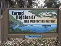 view gallery view galleryN15.1 km |  Carmel Highlands Fire Protection District - Carmel, CA Carmel Highlands Fire Protection District - Carmel, CA
in Firehouses The Carmel Highlands Fire Department is located on Fern Canyon Road in Carmel-By-The-Sea, California. posted by: DougK location: California date approved: 09/30/2009 last visited: never |
|