 view gallery view gallery SW0.3 km SW0.3 km
|   Andrew Molera S.P.: AM-8 Andrew Molera S.P.: AM-8
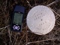
in U.S. Benchmarks Found this disk placed by the California Department of Parks and Recreation. posted by:  Touchstone Touchstone location: California date approved: 12/03/2005 last visited: never |
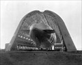
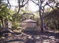 view gallery view gallerySW0.6 km |  Andrew Molera Water Tower Andrew Molera Water Tower
in Octagon Buildings Found this interesting shaped water tower on my way up the East Molera Trail to place a cache. posted by: Touchstone location: California date approved: 12/03/2005 last visited: 11/17/2018 |
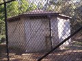 view gallery view gallerySW1 km |  Andrew Molera State Park Water Tower Andrew Molera State Park Water Tower
in Water Towers This interesting water tower was built in 2004 to supply water to the park housing and campsite of the Andrew Molera State Park along the scenic Big Sur coast. posted by: Touchstone location: California date approved: 12/03/2005 last visited: 11/17/2018 |
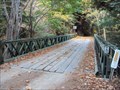
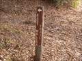 view gallery view gallerySW1 km |  East Molera Trail East Molera Trail
in Hiking and walking trailheads Short* trail heading inland from Molera State Beach posted by: toponym location: California date approved: 12/01/2018 last visited: never |
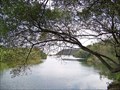 view gallery view gallerySW2.6 km |  DESTINATION - Big Sur River DESTINATION - Big Sur River
in River Origins, Destinations and Confluences N 36° 14.215 W 121° 46.211 posted by:  Bernd das Brot Team Bernd das Brot Team location: California date approved: 01/16/2007 last visited: never |
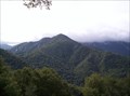
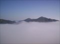 view gallery view gallery NE3.5 km NE3.5 km
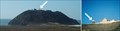
|  Pico Blanco Pico Blanco
in Mountain Summits Considered a sacred peak by the Esselen Tribe, Pico Blanco stands like a sentinel over the Big Sur coastline. The climb to the summit is a hefty 3,500 feet of elevation gain, but the views from the top make it all worthwhile. posted by: Touchstone location: California date approved: 11/03/2005 last visited: never |
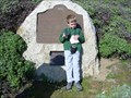
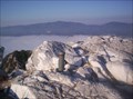 view gallery view galleryNE3.5 km |  Pico Blanco Register Pico Blanco Register
in Summit Registers The summit register atop Pinco Blanco was placed by the nearby Pico Blanco Boy Scout Camp. Apparently, the Scout Camp runs hikes to the summit during the middle of the night. Sounds like quite the adventure, but you may want to do it during the day. posted by: Touchstone location: California date approved: 11/03/2005 last visited: never |
 view gallery view gallery N4.3 km N4.3 km
|  Tantalus Hotsprings Tantalus Hotsprings
in Hot Springs A small unimproved hotsprings along the Little Sur River. Hard to get to, but nice to soak in. posted by: Touchstone location: California date approved: 06/24/2006 last visited: never |
 view gallery view gallery NW5 km NW5 km
|  Coast Road, North Fork of the Little Sur River - Monterey County, California Coast Road, North Fork of the Little Sur River - Monterey County, California
in Bailey Bridges This Bailey Bridge crosses the North Fork of the Little Sur River on the Coast Road about 5.7 miles SE of the Bixby Bridge California Highway 1. posted by: DougK location: California date approved: 10/04/2010 last visited: never |
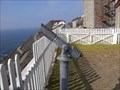 view gallery view gallery W6 km W6 km
|  Point Sur Lighthouse Monocular Point Sur Lighthouse Monocular
in Coin-Op Binoculars Free monocular at the Point Sur Lighthouse posted by: toponym location: California date approved: 11/24/2018 last visited: never |
 view gallery view galleryW6.1 km |  Lighthouse - KI6PAU Lighthouse - KI6PAU
in Amateur Radio Repeaters Repeater at Point Sur Lighthouse posted by: toponym location: California date approved: 12/23/2018 last visited: never |
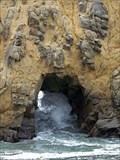 view gallery view gallery S6.3 km S6.3 km
|  Pfeiffer Beach Arch Pfeiffer Beach Arch
in Natural Arches A coastal rock formation with two large holes posted by: Bernd das Brot Team location: California date approved: 11/25/2006 last visited: 11/18/2018 |
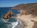
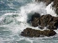 view gallery view galleryS6.3 km |  Pfeiffer Beach Pfeiffer Beach
in Wavy Places One of California's best hidden beaches posted by: Bernd das Brot Team location: California date approved: 10/08/2007 last visited: 08/10/2003 |
 view gallery view galleryW6.3 km |  Point Sur Water Tower Point Sur Water Tower
in Disguised Cell Towers When a well known wireless company asked the Point Sur State History Park for permission to build a tower, the answer was "Yes, but only if it blends in..." posted by: Bernd das Brot Team location: California date approved: 05/26/2006 last visited: 02/02/2019 |
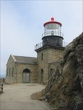 view gallery view galleryW6.3 km |  Point Sur Lightstation, California Point Sur Lightstation, California
in Coastal Lighthouses Point Sur, California posted by: GeoCraig location: California date approved: 09/26/2005 last visited: 11/18/2018 |
 view gallery view galleryW6.3 km |  POINT SUR LIGHT STATION POINT SUR LIGHT STATION
in California Historical Markers POINT SUR LIGHT STATION posted by: GeoCraig location: California date approved: 12/05/2005 last visited: 11/18/2018 |
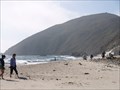 view gallery view galleryS6.3 km |  Pfeiffer Beach Pfeiffer Beach
in Beaches Pfeiffer Beach, Pfeiffer State Park posted by: eveningrose location: California date approved: 09/06/2010 last visited: 07/18/2010 |
 view gallery view galleryS6.3 km |  Pfeiffer Beach, Big Sur, California Pfeiffer Beach, Big Sur, California
in Off-Leash Dog Areas Popular beach in beautiful Big Sur posted by: Bernd das Brot Team location: California date approved: 02/15/2007 last visited: 02/28/2009 |
 view gallery view gallery SE6.3 km SE6.3 km
|  Pfeiffer Big Sur State Park Lodge Penny Smasher Pfeiffer Big Sur State Park Lodge Penny Smasher
in Penny Smashers This Penny Smasher is in the Pfeiffer Big Sur State Park Lodge at 47225 Highway One in Big Sur, California. posted by: brwhiz location: California date approved: 10/16/2011 last visited: never |
 view gallery view galleryS6.6 km |  Dragon's Back Trail, Big Sur, California Dragon's Back Trail, Big Sur, California
in Scenic Overlooks Absolutely the best view of the California coast. posted by: Bernd das Brot Team location: California date approved: 10/07/2007 last visited: never |
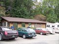
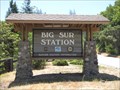 view gallery view gallerySE6.9 km |  Big Sur Ranger Station - Big Sur, California Big Sur Ranger Station - Big Sur, California
in Ranger Stations Big Sur Ranger Station in Big Sur, California is right on California Highway 1. posted by: DougK location: California date approved: 09/24/2009 last visited: never |
 view gallery view gallerySE8.4 km |  Big Sur, California 93920 Big Sur, California 93920
in U.S. Post Offices Post office along beautiful Highway 1 posted by: Bernd das Brot Team location: California date approved: 11/25/2006 last visited: 08/11/2011 |
 view gallery view gallerySW9.3 km |  The Macon Disaster The Macon Disaster
in Plane Crash Sites Riddle me this: how can an airplane crash into the ocean without a pilot, or for that matter, without even starting its engine. Read the description below on the demise of the USS Macon off of Point Sur, California and see how. posted by: Touchstone location: California date approved: 09/15/2005 last visited: 11/18/2018 |
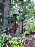 view gallery view gallerySE10.3 km |  Nepenthe Restaurant Fountain - Big Sur, CA Nepenthe Restaurant Fountain - Big Sur, CA
in Fountains A fountain found at Nepenthe Restaurant in Big Sur, CA. posted by: Mauison location: California date approved: 04/23/2007 last visited: 07/12/2007 |
 view gallery view gallery E10.6 km E10.6 km
| Ventana Double Cone in Mountain Summits Ventana Double Cone is in the heart of the Ventana Wilderness and offers unparalleled views of the interior wilderness area East of the Big Sur. posted by: Touchstone location: California date approved: 03/06/2006 last visited: 03/14/2007 |
|