 view gallery view gallery N21.6 km N21.6 km
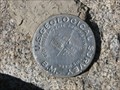
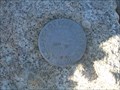
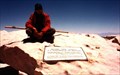
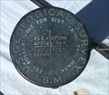
|   Trail Peak Benchmark Trail Peak Benchmark
in U.S. Benchmarks U. S. Geological Survey Benchmark at summit of Trail Peak in Golden Trout Wilderness of Inyo National Forest. posted by:  CoachDave45 CoachDave45 location: California date approved: 08/11/2010 last visited: never |
 view gallery view gallery E23.5 km E23.5 km
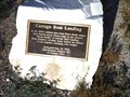
|  Cartago Boat Landing Cartago Boat Landing
in E Clampus Vitus Historical Markers In Cartago alongside the highway. posted by: fresgo location: California date approved: 05/24/2011 last visited: 05/23/2011 |
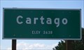 view gallery view galleryE23.5 km |  Cartago, CA - 3638 Feet Cartago, CA - 3638 Feet
in Elevation Signs Spotted this sign while driving on highway 395, somewhere north of Ridgecrest. posted by: Free2bme29 location: California date approved: 07/06/2009 last visited: 03/18/2014 |
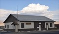 view gallery view galleryE24.3 km |  Olancha, California 93549 Olancha, California 93549
in U.S. Post Offices This Post Office is located at 100 S US Highway 395 in Olancha, California. posted by: brwhiz location: California date approved: 02/03/2013 last visited: 10/24/2018 |
 view gallery view galleryE24.5 km |  Farley's Olancha Mill Farley's Olancha Mill
in California Historical Markers Located just off US 395 in Downtown Olancha! posted by: fresgo location: California date approved: 05/27/2011 last visited: 09/15/2014 |
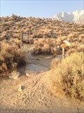
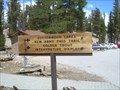 view gallery view galleryN24.8 km |  Golden Trout Wilderness, Horshoe Meadow Trailhead - California Golden Trout Wilderness, Horshoe Meadow Trailhead - California
in Hiking and walking trailheads Horseshoe Meadow Trailhead offers a relatively easy access point to Golden Trout Wilderness, but also the Southern portion of John Muir Wilderness. posted by: Touchstone location: California date approved: 09/02/2009 last visited: never |
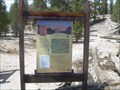 view gallery view galleryN24.8 km |  Horshoe Meadow Trailhead - Lone Pine, California Horshoe Meadow Trailhead - Lone Pine, California
in 'You Are Here' Maps A large map at the Horshoe Meadow Trailhead that gives would-be backpackers and hikers some idea of where they are. posted by: Touchstone location: California date approved: 09/02/2009 last visited: never |
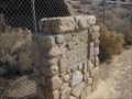
 view gallery view gallery NE29.1 km NE29.1 km
| Cottonwood Charcoal Kilns in E Clampus Vitus Historical Markers This ECV marker is just off Highway 395 near Owens Lake. posted by: Free2bme29 location: California date approved: 07/06/2009 last visited: 04/03/2011 |
 view gallery view galleryNE30.1 km | NO. 537 COTTONWOOD CHARCOAL KILNS in California Historical Markers COTTONWOOD CHARCOAL KILNS
posted by: GeoCraig location: California date approved: 09/08/2007 last visited: 04/03/2011 |
 view gallery view galleryN31.1 km | Mount Langley - California in U.S. Benchmarks A benchmark located on the summit of Mount Langley in the Sierra mountain range of California. posted by: Touchstone location: California date approved: 09/01/2009 last visited: 09/07/2016 |
 view gallery view galleryN31.1 km |  Mount Langley Mount Langley
in Mountain Summits The lowest of the 14'ers in California, as well as technically the easiest to reach and ascend. posted by: Touchstone location: California date approved: 08/31/2009 last visited: never |
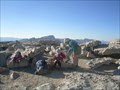
 view gallery view galleryN31.1 km |  Mount Langley - California Mount Langley - California
in Summit Registers Located on the summit of Mount Langley (14,022 feet) in the Southern Sierra of California. posted by: Touchstone location: California date approved: 08/30/2009 last visited: never |
 view gallery view gallery W36.2 km W36.2 km
|  Balch Park Campground Balch Park Campground
in Campgrounds A Tulare County Campground, situated within Mountain Home State Demonstration Forest. Sequoia Redwoods, two fishing ponds, nice camping areas and wildlife abound. Watch out for bears at night! posted by:  senoritafish senoritafish location: California date approved: 08/06/2013 last visited: never |
 view gallery view gallery SW36.2 km SW36.2 km
| Johnsondale Bridge, Kern River, California You Are Here Sign in 'You Are Here' Maps Johnsondale Bridge, Kern River, California posted by: toponym location: California date approved: 05/26/2009 last visited: never |
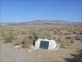
 view gallery view gallery SE36.9 km SE36.9 km
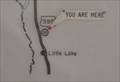
| Coso Roadside Rest Area in 'You Are Here' Maps You Are Here at the Coso Roadside Rest Area on the east side of US Highway 395 just north of Little Lake, California. posted by: brwhiz location: California date approved: 05/07/2013 last visited: 12/29/2014 |
 view gallery view gallerySE36.9 km |  Coso Safety Roadside Rest Area ~ Inyo County, California Coso Safety Roadside Rest Area ~ Inyo County, California
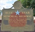
in Blue Star Memorial Highway Markers This Blue Star Memorial Highway Marker is located in the Coso Safety Roadside Rest Area on the east side of US Highway 395 just south of Gill Station Coso Road north of Indian Wells, California. posted by: brwhiz location: California date approved: 03/01/2013 last visited: 10/25/2018 |
 view gallery view gallerySE37 km |  Coso Safety Roadside Rest Area Coso Safety Roadside Rest Area
in Highway Rest Areas This Highway Rest Area is located on the east side of US Highway 395 just south of Gill Station Coso Road north of Indian Wells, California. posted by: brwhiz location: California date approved: 02/25/2013 last visited: 12/29/2014 |
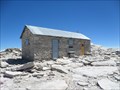 view gallery view galleryN37 km |  Smithsonian Institution Shelter - Mt. Whitney, CA Smithsonian Institution Shelter - Mt. Whitney, CA
in U.S. National Register of Historic Places Mt. Whitney Smithsonian Research Facility
Sequoia National Park, CA posted by: fresgo location: California date approved: 08/06/2013 last visited: 08/05/2013 |
 view gallery view galleryN37 km | Mt. Whitney in Mountain Summits Mt Whitney is the highest point in the contiguous United States. posted by: wilsonjw location: California date approved: 09/08/2005 last visited: 08/01/2013 |
 view gallery view galleryN37 km |  Highest Point in California (Mt Whitney) Highest Point in California (Mt Whitney)
in Geographic High Points Mt Whitney at 14,505 feet is the highest point in California, as well as the lower 48 states and both Tulare and Inyo counties. posted by: Rumpled location: California date approved: 10/20/2008 last visited: 08/04/2013 |
 view gallery view galleryN37 km | Highest Point in Tulare County (Mt Whitney) in Geographic High Points Mt Whitney at 14,505 feet is the highest point in Tulare County, as well as the lower 48 states, the state of California and Inyo County. posted by: Rumpled location: California date approved: 10/20/2008 last visited: 08/04/2013 |
 view gallery view galleryN37 km | Highest Point in Inyo County (Mt Whitney) in Geographic High Points Mt Whitney at 14,505 feet is the highest point in Inyo County, as well as the lower 48 states, the state of California and Tulare County.
posted by: Rumpled location: California date approved: 10/20/2008 last visited: 08/01/2013 |
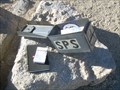
 view gallery view gallerySE37.2 km | X Marks Spot F1905 in U.S. Benchmarks This benchmark is right next to X Marks Spot Geocache. posted by: Team Ulogoit location: California date approved: 10/22/2009 last visited: 12/29/2014 |
 view gallery view galleryN39.9 km | Whitney Portal National Recreation Trail in Hiking and walking trailheads Lone Pine Campground, Inyo National Forest. The trail head is at the west end of the campground. Parking is available in the Day Use Area. posted by: fresgo location: California date approved: 08/11/2013 last visited: never |
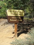 view gallery view gallerySW41.7 km | Trail of 100 Giants - Sequoia National Monument, California in Hiking and walking trailheads The Trail of 100 Giants is the most popular attraction in the Giant Sequoia National Monument, and it's easy to see why. The trail is easy to get to, it's short, flat, and paved, and it's got a lot of really impressive trees. posted by: DougK location: California date approved: 03/18/2016 last visited: never |
|