 view gallery view gallery NW11.1 km NW11.1 km
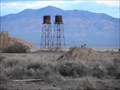
|   Towers - Death Valley Junction National Historic District, CA Towers - Death Valley Junction National Historic District, CA
in NRHP Historic Districts - Contributing Buildings Old water towers that once served the borax processing plant in Death Valley Junction. posted by:  jiggs11 jiggs11 location: California date approved: 05/27/2017 last visited: never |
 view gallery view galleryNW11.3 km |  Death Valley Junction Motors - Death Valley Junction, CA Death Valley Junction Motors - Death Valley Junction, CA
in Ghost Signs Sun-faded and weather-beaten sign for the old garage in Death Valley Junction, CA. posted by: jiggs11 location: California date approved: 05/26/2015 last visited: 03/06/2016 |
 view gallery view galleryNW11.3 km |  Tonopah and Tidewater Railroad Museum -- Death Valley Junction CA Tonopah and Tidewater Railroad Museum -- Death Valley Junction CA
in Railroad Museums A small railroad museum featuring rare artifacts and a large model railroad layout for the route of the Tonopah and Tidewater Railroad in Death Valley Junction CA posted by: Benchmark Blasterz location: California date approved: 03/28/2016 last visited: 03/29/2016 |
 view gallery view galleryNW11.3 km |  Tonopah and Tidewater Railroad Museum -- Death Valley Junction CA Tonopah and Tidewater Railroad Museum -- Death Valley Junction CA
in Model Railroads A small railroad museum featuring a large model railroad layout for the route of the Tonopah and Tidewater Railroad in Death Valley Junction CA posted by: Benchmark Blasterz location: California date approved: 03/30/2016 last visited: 03/06/2016 |
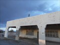
 view gallery view galleryNW11.3 km |  Death Valley Junction Historic District Death Valley Junction Historic District
in U.S. National Register of Historic Places Death Valley Junction was built in the 1920s as a mining town owned by the Pacific Borax Company. Today it's owned by the Amargosa Opera House, Inc., to save the pictures painted in the old recreation house by Marta Becket. posted by: rambles location: California date approved: 01/26/2008 last visited: 03/06/2016 |
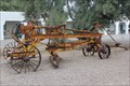 view gallery view galleryNW11.3 km |  1920s Borax mining equipment -- Death Valley Junction CA 1920s Borax mining equipment -- Death Valley Junction CA
in Preserved Machines on Public Display Some rusting pieces of old Borax mining equipment on display in front of the Amargosa Hotel in Death Valley Junction posted by: Benchmark Blasterz location: California date approved: 03/29/2016 last visited: 02/25/2017 |
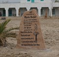 view gallery view galleryNW11.4 km |  Marta Becket -- Death Valley Junction CA Marta Becket -- Death Valley Junction CA
in Citizen Memorials An engraved sandstone memorial to Marta Becket, creator of the Amargosa Opera House in Death Valley Junction posted by: Benchmark Blasterz location: California date approved: 03/28/2016 last visited: 03/29/2016 |
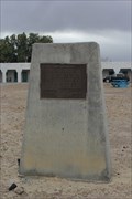 view gallery view galleryNW11.4 km |  Death Valley Junction -- Death Valley Junction CA Death Valley Junction -- Death Valley Junction CA
in E Clampus Vitus Historical Markers The ECV historic marker for the town of Death Valley Junction, along CA 127 posted by: Benchmark Blasterz location: California date approved: 04/02/2016 last visited: 02/25/2017 |
 view gallery view galleryNW11.4 km | Amargosa Opera House in E Clampus Vitus Historical Markers Death Valley Junction is just a wide spot in the road but there is a lot of history there. posted by: Free2bme29 location: California date approved: 02/22/2010 last visited: 02/12/2018 |
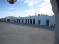
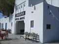
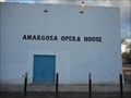 view gallery view galleryNW11.4 km |  Amargosa Opera House - Death Valley Junction, CA Amargosa Opera House - Death Valley Junction, CA
in Roadside Attractions A little spot of culture in a barren desert environment! posted by: jiggs11 location: California date approved: 09/06/2016 last visited: 01/15/2012 |
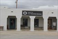
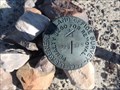
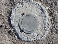 view gallery view galleryNW11.4 km |  Benchmark: GS0409 Benchmark: GS0409
in U.S. Benchmarks Across the street from the Amargosa Opera House on the way to Death Valley. posted by:  imlosthere imlosthere location: California date approved: 07/07/2008 last visited: 03/06/2016 |
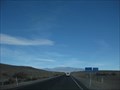
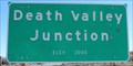 view gallery view galleryNW11.6 km |  Death Valley Junction CA (Northern Approach) - 2000' Death Valley Junction CA (Northern Approach) - 2000'
in Elevation Signs The sign is at the northern approach to Death Valley Junction on Highway 127. posted by: WR7X location: California date approved: 02/12/2016 last visited: 03/06/2016 |
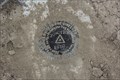 view gallery view galleryNW11.7 km | GS0410 Junction -- Death Valley Junction, CA in U.S. Benchmarks An NGS Trianguation station and 2 reference marks (each with PIDs) along CA SH 190 in Death Valley National Park posted by: Benchmark Blasterz location: California date approved: 03/31/2016 last visited: 03/07/2016 |
 view gallery view gallery N14.6 km N14.6 km
|  Nevada/California Border on Bell Vista Road/Bob Ruud Memorial Highway Nevada/California Border on Bell Vista Road/Bob Ruud Memorial Highway
in Border Crossings This border crossing occurs about 16 miles northwest of Pahrump on Bell Vista Road/Bob Ruud Memorial Highway, a road that sees very little traffic. posted by: brwhiz location: Nevada date approved: 09/19/2012 last visited: 03/06/2016 |
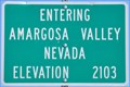 view gallery view galleryN14.6 km | Amargosa Valley ~ Elevation 2103 Feet in Elevation Signs This Elevation sign is located on Bell Vista Road/Bob Ruud Memorial Highway at the California/Nevada border. posted by: brwhiz location: Nevada date approved: 09/21/2012 last visited: 03/06/2016 |
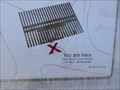
 view gallery view galleryN16.9 km |  You Are Here - Entrance to Ash Meadows National Wildlife Refuge - NV You Are Here - Entrance to Ash Meadows National Wildlife Refuge - NV
in 'You Are Here' Maps You Are Here map on the information kiosk at the south entrance to Ash Meadows National Wildlife Refuge. posted by: jiggs11 location: Nevada date approved: 12/23/2017 last visited: 10/06/2017 |
 view gallery view galleryN17.1 km |  S26 S25 - Ash Meadows National Wildlife Refuge - NV S26 S25 - Ash Meadows National Wildlife Refuge - NV
in Public Land Survey Marks US General Land Office Survey Mark located inside Ash Meadows National Wildlife Refuge. posted by: jiggs11 location: Nevada date approved: 12/22/2017 last visited: never |
 view gallery view gallery NE17.9 km NE17.9 km
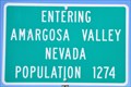
|  Amargosa Valley ~ Population 1274 Amargosa Valley ~ Population 1274
in Population Signs This Population Sign is at the southern edge of Amargosa Valley on Bell Vista Road/Bob Ruud Memorial Highway. posted by: brwhiz location: Nevada date approved: 09/19/2012 last visited: never |
 view gallery view galleryN22.4 km | You Are Here - Point of Rocks Boardwalk - Ash Meadows NWR - NV in 'You Are Here' Maps You Are Here at the start of the Point of Rocks boardwalk nature trail. posted by: jiggs11 location: Nevada date approved: 12/23/2017 last visited: 10/06/2017 |
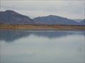 view gallery view galleryN22.5 km |  Ash Meadows National Wildlife Refuge - Nevada Ash Meadows National Wildlife Refuge - Nevada
in National Wildlife Refuges Ash Meadows is an oasis in the middle of the Mojave Desert. The refuge is made up of spring-fed wetlands and alkaline desert uplands. posted by: Free2bme29 location: Nevada date approved: 02/11/2010 last visited: 10/06/2017 |
 view gallery view gallery E22.7 km E22.7 km
| CA/NV on Hwy 178 in Border Crossings Just southeast of Pahrump, NV, connects to Shoshone, CA and Death Valley. posted by: ChapterhouseInc location: Nevada date approved: 01/17/2011 last visited: 11/25/2022 |
 view gallery view galleryN22.7 km | CA/NV on California 127/Nevada 373 in Border Crossings This Border Crossing is about 16 miles south of the junction of Nevada Highway 373 and US Highway 95 at Amargosa Valley, Nevada. posted by: brwhiz location: California date approved: 12/13/2012 last visited: 03/02/2015 |
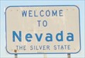 view gallery view galleryN22.7 km |  Welcome to Nevada ~ "The Silver State" Welcome to Nevada ~ "The Silver State"
in Welcome Signs This sign welcomes you as you cross the California/ Nevada border on Nevada Highway 373 heading toward Amargosa Velley, Nevada. posted by: brwhiz location: Nevada date approved: 12/13/2012 last visited: 03/02/2015 |
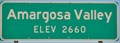 view gallery view galleryN23 km | Amargosa Valley ~ Elevation 2660 Feet in Elevation Signs This Elevation Sign is located on the east side of Spring Street (Nevada Highway 373) at Lincoln Road on the southern town limits of Beatty, Nevada. posted by: brwhiz location: Nevada date approved: 05/06/2013 last visited: never |
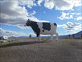 view gallery view galleryN23 km | Giant Cow - Amargosa Valley, NV in Roadside Attractions Large black and white Holstein located next to NV 373 just west of the Longstreet Inn and Casino in Amargosa Valley. posted by: jiggs11 location: Nevada date approved: 01/23/2016 last visited: never |
|