 view gallery view gallery W23.3 km W23.3 km
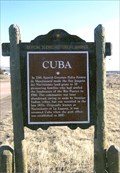
|   Cuba - Cuba, New Mexico Cuba - Cuba, New Mexico
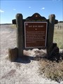
in New Mexico Historical Markers Small town in northwest New Mexico. posted by:  YoSam. YoSam. location: New Mexico date approved: 03/04/2009 last visited: 08/12/2022 |
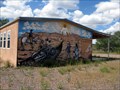 view gallery view galleryW23.3 km |  All are Welcome - near Cuba, NM All are Welcome - near Cuba, NM
in Murals This mural is located just off of highway 550 near the small town of Cuba, New Mexico. posted by: Queens Blessing location: New Mexico date approved: 10/08/2011 last visited: 09/16/2012 |
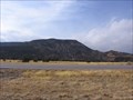
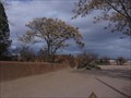
 view gallery view galleryW23.8 km |  Cuba, New Mexico Cuba, New Mexico
in Wikipedia Entries Hard to imagine this area as lakes and swamps posted by: YoSam. location: New Mexico date approved: 08/10/2016 last visited: never |
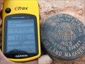
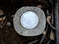
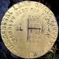
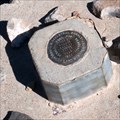 view gallery view gallery NW24.1 km NW24.1 km
|  Initial Point Initial Point
in Public Land Survey Marks This is the Initial Point from which all land surveys (township and range) are measured. There is only one of these in New Mexico. posted by:  roland505 roland505 location: New Mexico date approved: 03/30/2016 last visited: never |
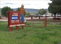 view gallery view galleryW24.5 km |  Smokey Bear in Cuba, New Mexico Smokey Bear in Cuba, New Mexico
in Smokey Bear Sign Sightings This Smokey Bear sign is displayed near the road in front of the Ranger Station in Cuba, New Mexico. posted by: Queens Blessing location: New Mexico date approved: 10/09/2011 last visited: 09/02/2013 |
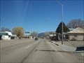
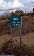 view gallery view galleryW24.5 km |  Elevation 6905, Cuba, New Mexico Elevation 6905, Cuba, New Mexico
in Elevation Signs Cuba, New Mexico has a population of about 590 as of 2011. posted by: Queens Blessing location: New Mexico date approved: 10/01/2011 last visited: 08/12/2022 |
 view gallery view galleryW29 km | San Juan Basin - Cuba, NM in New Mexico Historical Markers New Mexico Historical Marker located in a roadside pullout northwest of Cuba on the north side of US 550, providing some background about the San Juan Basin. posted by: QuarrellaDeVil location: New Mexico date approved: 10/14/2016 last visited: 08/12/2022 |
 view gallery view gallery S31.4 km S31.4 km
|  McCauley Natural Warm Spring McCauley Natural Warm Spring
in Hot Springs Half way between Jemez Falls Trailhead and Battleship Rock Picnic Grounds. posted by: RakeInTheCache location: New Mexico date approved: 11/04/2006 last visited: 05/28/2007 |
 view gallery view gallery NE32.5 km NE32.5 km
|  U.S. 84 Near Chama Reservoir, New Mexico U.S. 84 Near Chama Reservoir, New Mexico
in Scenic Roadside Look-Outs A roadside stop in the landscape so prized by the American painter Georgia O'Keefe. posted by: RakeInTheCache location: New Mexico date approved: 12/30/2006 last visited: never |
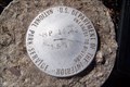
 view gallery view galleryNE34.6 km |  Ghost Ranch Campground Ghost Ranch Campground
in U.S. Benchmarks this is a disk in the middle of the road, very easy to find, in the ghost ranch campground. posted by: exene7 location: New Mexico date approved: 07/23/2009 last visited: never |
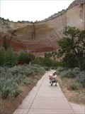 view gallery view galleryNE34.8 km |  Echo Ampitheater, Abiquiu New Mexico Echo Ampitheater, Abiquiu New Mexico
in Places of Geologic Significance Take a short walk to visit a sandstone depression with fun acoustic properties. posted by: PaulPosition location: New Mexico date approved: 03/04/2007 last visited: 03/26/2018 |
 view gallery view galleryS35.1 km |  Jemez State Ruins Jemez State Ruins
in Preserved Architectural Remnants and Ruins Jemez Ruins posted by: kingbee location: New Mexico date approved: 03/05/2009 last visited: 02/20/2016 |
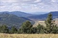
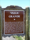 view gallery view gallery SE35.6 km SE35.6 km
| Valle Grande - Highway 4, New Mexico in New Mexico Historical Markers This gorgeous valley was formed 1 million years ago when a massive explosion caused a great collapse, forming a massive caldera. posted by: Hikenutty location: New Mexico date approved: 07/05/2010 last visited: 03/23/2016 |
 view gallery view gallerySE36.9 km |  Cerro Grande Cerro Grande
in Mountain Summits Cerro Grande, NM. Where the fire that burned Los Alamos started. posted by: EleniJohn location: New Mexico date approved: 09/11/2005 last visited: 07/18/2010 |
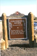 view gallery view galleryW37.8 km | Continental Divide - N. of Cuba, NM in New Mexico Historical Markers The spot where water goes this way and that. posted by: YoSam. location: New Mexico date approved: 03/28/2009 last visited: 08/12/2022 |
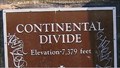 view gallery view galleryW37.8 km | Continental Divide - N. of Cuba, New Mexico - 7,379' in Elevation Signs The spot where water goes this way and that. posted by: YoSam. location: New Mexico date approved: 08/06/2016 last visited: 08/12/2022 |
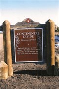 view gallery view galleryW37.8 km |  Continental Divide - N. of Cuba, New Mexico, USA Continental Divide - N. of Cuba, New Mexico, USA
in Watershed Markers and Monuments The spot where water goes this way and that. posted by: YoSam. location: New Mexico date approved: 10/04/2017 last visited: 08/12/2022 |
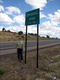 view gallery view galleryW37.8 km | Continential Divide Elevation 7380 in New Mexico in Elevation Signs This is the official highway sign that marks the Continental Divide on Hwy 550. posted by: Queens Blessing location: New Mexico date approved: 10/07/2011 last visited: 12/30/2020 |
 view gallery view gallery E37.8 km E37.8 km
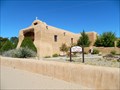
|  Saint Thomas the Apostle - Abiquiu, New Mexico Saint Thomas the Apostle - Abiquiu, New Mexico
in Roman Catholic Churches This new church, built in 1935, replaced an older one that burned in 1860. The church anchors the main plaza of Abiquiu. posted by: iconions location: New Mexico date approved: 09/21/2017 last visited: never |
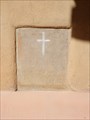 view gallery view galleryE37.8 km |  1935 - Santo Tomas el Apostol - Abiquiu, New Mexico 1935 - Santo Tomas el Apostol - Abiquiu, New Mexico
in Dated Buildings and Cornerstones This new church, built in 1935, replaced an older one that burned in 1860. The church anchors the main plaza of Abiquiu. posted by: iconions location: New Mexico date approved: 09/21/2017 last visited: never |
 view gallery view galleryE38 km |  O'Keefe, Georgia, Home and Studio O'Keefe, Georgia, Home and Studio
in U.S. National Register of Historic Places The home and studio of the artist Georgia O'Keeffe (1887-1986) in Abiquiu, New Mexico (approximately 50 miles northwest of Santa Fe), is one of the most important artistic sites in the southwestern United States. posted by: RakeInTheCache location: New Mexico date approved: 12/20/2006 last visited: 09/20/2017 |
 view gallery view gallerySE40.1 km | NPS Boundary Marker MP 11.64 1978 in U.S. Benchmarks National Park Service Boundary Marker for Bandelier National Monument.
posted by: Mesa Mike location: New Mexico date approved: 03/20/2008 last visited: never |
 view gallery view gallerySE40.1 km | NPS Boundary Marker MP 12.43 1978 in U.S. Benchmarks National Park Service Boundary Marker for Bandelier National Monument. posted by: Mesa Mike location: New Mexico date approved: 03/20/2008 last visited: never |
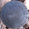 view gallery view gallerySE40.2 km | GLO Quarter Section Corner Marker T19N R6E S18 on western boundary in U.S. Benchmarks A General Land Office quarter section corner survey marker on the western boundary of S18 in T19N R6E. posted by: Mesa Mike location: New Mexico date approved: 04/03/2008 last visited: never |
 view gallery view gallerySE40.9 km | GLO Closing Corner Marker BL / T19NR5ES34/T18NR5ES3 in U.S. Benchmarks A General Land Office closing corner survey marker set at the point where the township line dividing T19N R5E S34 and T18N R5E S3 closes on the Baca Location #1 boundary. posted by: Mesa Mike location: New Mexico date approved: 03/31/2008 last visited: never |
|