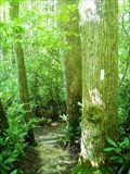
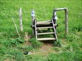
 view gallery view gallery E0.5 km E0.5 km
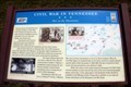
|   Civil War in Tennessee - War in the Mountains - Erwin, TN Civil War in Tennessee - War in the Mountains - Erwin, TN
in Civil War Discovery Trail Sites The Tennessee mountains were split between Union and the Confederacy during the war. posted by:  Markerman62 Markerman62 location: Tennessee date approved: 08/15/2021 last visited: never |
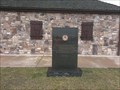 view gallery view galleryE0.5 km |  Tennessee AmVets Memorial - Unicoi County TN Tennessee AmVets Memorial - Unicoi County TN
in Non-Specific Veteran Memorials AmVets memorial placed at the I-26 north welcome center in Unicoi County, TN posted by: gpsblake location: Tennessee date approved: 01/13/2015 last visited: 05/28/2017 |
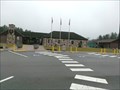 view gallery view galleryE0.5 km |  I-26 N - Welcome Center - Unicoi county, TN I-26 N - Welcome Center - Unicoi county, TN
in Highway Rest Areas Welcome center as you enter I-26 north bound entering Tennessee from North Carolina. posted by: gpsblake location: Tennessee date approved: 01/15/2015 last visited: 05/28/2017 |
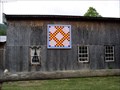 view gallery view gallery NE5.1 km NE5.1 km
|  Double Irish Chain at Double "D" Roost Barn-Erwin, Tennessee Double Irish Chain at Double "D" Roost Barn-Erwin, Tennessee
in Painted Barn Quilts Double Irish Chain Pattern located of Campground and Store
3333 Temple Hill Road posted by:  Countrydragon Countrydragon location: Tennessee date approved: 11/24/2009 last visited: 06/26/2010 |
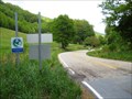
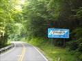 view gallery view galleryE7.1 km |  Tennessee/North Carolina on US 19W Tennessee/North Carolina on US 19W
in Border Crossings Before I-26 was constructed, this winding highway was one of the main routes through the mountains between the two states. posted by: vhasler location: North Carolina date approved: 07/22/2013 last visited: never |
 view gallery view galleryE7.2 km |  Tennessee Line to Asheville - Burnsville, TN Tennessee Line to Asheville - Burnsville, TN
in American Guide Series US 19W north end at Tennessee Line is at Spivey Creek Gap. posted by: vhasler location: North Carolina date approved: 07/22/2013 last visited: never |
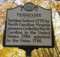 view gallery view galleryE7.2 km |  Tennessee ~ N 16 Tennessee ~ N 16
in North Carolina Historical Markers A marker noting the early statehood history of Tennessee located near Burnsville, North Carolina posted by: PersonsMD location: North Carolina date approved: 11/05/2010 last visited: 10/16/2010 |
 view gallery view gallery S7.6 km S7.6 km
| Big Bald Mountain - TN/NC border in American Guide Series A high point on the Appalachian Trail has an old story to tell... posted by: vhasler location: North Carolina date approved: 07/20/2013 last visited: never |
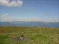
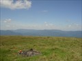 view gallery view galleryS7.6 km |  Big Bald - Highest Point in Unicoi County, TN Big Bald - Highest Point in Unicoi County, TN
in Geographic High Points Big Bald is right at the TN/NC state line - and the Applachian Trail runs across the peak. posted by: vhasler location: Tennessee date approved: 11/03/2009 last visited: never |
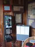 view gallery view galleryNE8.4 km |  Payphone at Uncle Johnny's Hostel - Erwin, TN Payphone at Uncle Johnny's Hostel - Erwin, TN
in Payphones A really busy payphone during thru-hiker season on the Appalachian Trail posted by: vhasler location: Tennessee date approved: 01/14/2009 last visited: never |
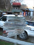 view gallery view galleryNE8.4 km |  Direction Sign at Uncle Johnny's Hostel - Erwin, TN Direction Sign at Uncle Johnny's Hostel - Erwin, TN
in Appalachian Trail This sign is right on the AT at the turn where trail comes down from Temple Hill and heads over a bridge on the Nolichucky River to Jones Branch section. Katahdin 1822.4 miles to the north - Springer 337.9 miles South. posted by: vhasler location: Tennessee date approved: 01/14/2009 last visited: never |
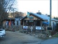 view gallery view galleryNE8.4 km |  Uncle Johnny's Nolichucky Hostel - Erwin, TN Uncle Johnny's Nolichucky Hostel - Erwin, TN
in Hostels A "zero day" hostel right on the Appalachian Trail at the Nolichucky River. posted by: vhasler location: Tennessee date approved: 01/11/2009 last visited: never |
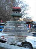 view gallery view galleryNE8.4 km |  Direction/Distance Sign - Nolichucky Hostel - Erwin, TN Direction/Distance Sign - Nolichucky Hostel - Erwin, TN
in Direction and Distance Arrows For most of the people staying here, the real distance goal is Katahdin (Maine) 1822.4 miles northbound or Springer (Georgia) 337.9 miles southbound - on foot on the Appalachian Trail (AT). posted by: vhasler location: Tennessee date approved: 01/23/2009 last visited: never |
 view gallery view galleryNE9 km | The Tennessee Iris in Unicoi County TN in Painted Barn Quilts Located on HWY 352 this bright red barn can not be missed even if you are on I 26 posted by: Tnmadhatter_01 location: Tennessee date approved: 06/27/2010 last visited: 01/02/2014 |
 view gallery view galleryE9 km | Appalachian Trail - Spivey Creek Gap in American Guide Series The famous long-distance trail crosses US 19W near the TN-NC state line. Follow the white blazes... posted by: vhasler location: North Carolina date approved: 07/22/2013 last visited: never |
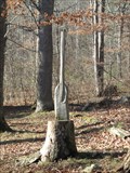 view gallery view galleryNE9 km |  Rafting Paddle at USA Rafting - Erwin, TN Rafting Paddle at USA Rafting - Erwin, TN
in Outside Wooden Display Carvings A rafting paddle carved into a stump at the USA Rafting place along the Nolichucky River posted by: vhasler location: Tennessee date approved: 01/11/2009 last visited: never |
 view gallery view galleryNE9 km |  You Are Here - Nolichucky River Take Out - Erwin, TN You Are Here - Nolichucky River Take Out - Erwin, TN
in 'You Are Here' Maps "You Are Here" at the take-out location on the Nolichucky River for USA Raft company. The map shows some of the named Class 4 whitewater rapids on this river section. posted by: vhasler location: Tennessee date approved: 01/14/2009 last visited: never |
 view gallery view galleryNE9 km |  USA Raft - Nolichucky River - Erwin, TN USA Raft - Nolichucky River - Erwin, TN
in Whitewater Rafting Trips USA Raft offers half and full day trips on the Nolichucky River with Class 2-4 rapids. The river is not controlled by a TVA dam, thus spring trips are high water, while summer are technical. posted by: vhasler location: Tennessee date approved: 01/17/2009 last visited: never |
 view gallery view gallery SW9.5 km SW9.5 km
|  Devil's Fork Gap Devil's Fork Gap
in Named Mountain Gaps Through the Bald Mountains of the Appalachian Mountain range. posted by: vhasler location: Tennessee date approved: 06/08/2014 last visited: never |
 view gallery view galleryNE9.7 km |  Jones Branch Bridge #1 - Appalachian Trail - Erwin, TN Jones Branch Bridge #1 - Appalachian Trail - Erwin, TN
in Hiking Path Footbridges First bridge encountered northbound on the Appalachian Trail heading out of Erwin, TN. posted by: vhasler location: Tennessee date approved: 12/24/2014 last visited: never |
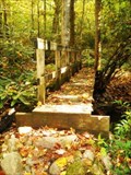
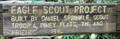 view gallery view galleryNE9.7 km |  Appalachian Trail bridge - Daniel Sprinkle - Erwin, TN Appalachian Trail bridge - Daniel Sprinkle - Erwin, TN
in Eagle Scout Project Sites Built in 1994 to span a small creek in the Jones Branch bottomland. posted by: vhasler location: Tennessee date approved: 12/26/2014 last visited: never |
 view gallery view gallerySW9.7 km | NC/TN - Hwys NC212/TN352 in Border Crossings Devils Fork Gap posted by: vhasler location: Tennessee date approved: 06/07/2014 last visited: never |
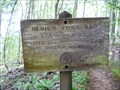 view gallery view gallerySW9.7 km |  Devil's Fork Gap - NC - 3107 Ft Devil's Fork Gap - NC - 3107 Ft
in Elevation Signs Appalachian Trail SB sign informs that Devil's Fork Gap is 3,107' above sea level... and you know you're hiking UP for the next few miles. posted by: vhasler location: North Carolina date approved: 06/07/2014 last visited: never |
 view gallery view gallerySW9.7 km | Devils Fork Gap - NC in Appalachian Trail Trailhead with roughly 6-8 parking spots posted by: vhasler location: North Carolina date approved: 06/07/2014 last visited: never |
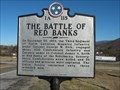 view gallery view galleryNE10 km |  The Battle of Red Banks/Reunion for Boys in Blue - 1A115 - Erwin, TN The Battle of Red Banks/Reunion for Boys in Blue - 1A115 - Erwin, TN
in Tennessee Historical Markers In 1864, the Union won a battle of mounted infantry and calvary forces at Red Bank near the Nolichucky River. posted by: vhasler location: Tennessee date approved: 01/10/2009 last visited: 09/24/2015 |
|