 view gallery view gallery N12.6 km N12.6 km
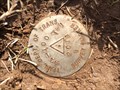
|   TNDOT 94-840-16 - Williamson County, TN TNDOT 94-840-16 - Williamson County, TN
in U.S. Benchmarks TNDOT 94-840-16 posted by:  CuriousBM CuriousBM location: Tennessee date approved: 04/24/2015 last visited: never |
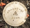 view gallery view galleryN12.6 km | TNDOT 94-840-15 - Williamson County, TN in U.S. Benchmarks TNDOT 94-840-15 posted by: CuriousBM location: Tennessee date approved: 04/24/2015 last visited: never |
 view gallery view gallery NW13 km NW13 km
| ") Unnamed cave along Jones Creek Unnamed cave along Jones Creek
in Cave Entrances (Natural) A small but unique cave overlooking Jones Creek on Thompson Ln. posted by: wtschume location: Tennessee date approved: 07/20/2011 last visited: never |
 view gallery view galleryNW13.4 km |  Old Falls Old Falls
in Waterfalls A beautiful 20' falls about 35' wide visible from Cavender Rd. posted by: wtschume location: Tennessee date approved: 07/14/2011 last visited: never |
 view gallery view gallery E14.2 km E14.2 km
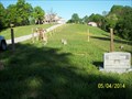
|  Sedberry Cemetery - Thompson Station, TN Sedberry Cemetery - Thompson Station, TN
in Worldwide Cemeteries A small antebellum cemetery in rural Williamson County, Tennessee posted by: MountainWoods location: Tennessee date approved: 05/05/2014 last visited: 05/04/2014 |
  SE15.4 km SE15.4 km
|  Chickasaw Trace trail Chickasaw Trace trail
in Mountain Bike Trailheads 7.7 miles of great singletrack posted by:  susy1313 susy1313 location: Tennessee date approved: 11/12/2005 last visited: never |
 view gallery view gallery W16.1 km W16.1 km
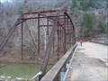
|  Old Tottys Bend Bridge Old Tottys Bend Bridge
in Orphaned Bridges Old bridge crossing the Duck River on Tottys Bend Rd or Co Hwy 1846 in Hickman County TN. posted by: wtschume location: Tennessee date approved: 07/20/2011 last visited: never |
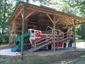 view gallery view galleryE16.7 km |  Deer Run Camps & Retreats Covered Playground Deer Run Camps & Retreats Covered Playground
in Public Playgrounds Deer Run Camps & Retreats Covered Playground posted by: CuriousBM location: Tennessee date approved: 08/24/2016 last visited: never |
 view gallery view galleryN17.9 km | TNDOT 94-100-W1, Fairview, TN in U.S. Benchmarks TNDOT 94-100-W1, Fairview, TN posted by: CuriousBM location: Tennessee date approved: 03/02/2015 last visited: never |
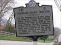 view gallery view gallery NE18 km NE18 km
|  Thomas Hart Benton 3D 6 Thomas Hart Benton 3D 6
in Tennessee Historical Markers Historical marker describing Thomas Hart Benton and his house, which stood on this site. posted by: gbworld location: Tennessee date approved: 04/05/2008 last visited: never |
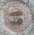 view gallery view galleryN18.5 km | Fairview, TN - CANEY Tri-Station - FD1509 in U.S. Benchmarks Fairview, TN benchmark - FD1509 posted by: CuriousBM location: Tennessee date approved: 02/20/2015 last visited: never |
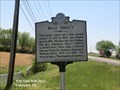
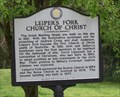 view gallery view galleryNE19.2 km | Leiper's Fork Chuch of Christ in Tennessee Historical Markers Sign describing the founding of the Leiper's Fork Church of Christ. posted by: gbworld location: Tennessee date approved: 04/05/2008 last visited: 06/20/2021 |
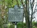 view gallery view gallerySE19.2 km | Polk's Boyhood Home (3D 21) - Columbia TN in Tennessee Historical Markers The first house here was built by Maj. Samuel Polk, who came here from North Carolina in 1806. In his family was the ten-year-old son, James Knox Polk. posted by: Don.Morfe location: Tennessee date approved: 10/14/2020 last visited: 10/20/2021 |
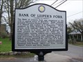 view gallery view galleryNE19.2 km | Bank of Leiper's Fork/Hillsboro United Methodist Church in Tennessee Historical Markers Sign telling about the Bank of Leiper's Fork and the Hillsboro United Methodist Church. posted by: gbworld location: Tennessee date approved: 04/05/2008 last visited: 05/21/2009 |
 view gallery view gallerySE19.3 km |  Cedar Hills Pet Cemetery - Columbia, TN Cedar Hills Pet Cemetery - Columbia, TN
in Pet Cemeteries A peaceful park setting just off the main highway leading into Columbia. Lots of contemplation settings and some really beautiful markers. posted by: horizon seeker location: Tennessee date approved: 02/24/2008 last visited: 02/14/2008 |
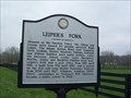 view gallery view galleryNE19.6 km | Leiper's Fork in Tennessee Historical Markers Sign telling about the founding of Leiper's Fork, a small community southwest of Franklin, TN. posted by: gbworld location: Tennessee date approved: 04/05/2008 last visited: 04/27/2013 |
 view gallery view galleryE19.6 km | Billy Direct (3D 47) - Columbia TN in Tennessee Historical Markers This horse, which set a mile pacing record of 1:55 in 1938, was foaled here in 1931. His dam was Gay Forbes posted by: Don.Morfe location: Tennessee date approved: 10/14/2020 last visited: 10/20/2021 |
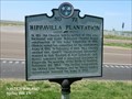
 view gallery view galleryE20 km |  Rippavilla Plantation (3D 72) - Spring Hill TN Rippavilla Plantation (3D 72) - Spring Hill TN
in American Civil War Monuments and Memorials Marker is at 5700 Main Street, Spring Hill TN 37174. Cheairs raised two companies for the Confederate Army in 1861. In February of 1862, Maj. Cheairs carried Gen. Grant's "unconditional surrender" demand to Gen. Buckner at Fort Donelson. posted by: Don.Morfe location: Maryland date approved: 10/08/2023 last visited: 10/08/2023 |
 view gallery view galleryE20 km | Rippavilla Plantation (3D 72) - Spring Hill TN in Tennessee Historical Markers In 1811, the Cheairs family settled at this site. Nathaniel and Susan McKissack Cheairs began construction of this home, Rippavilla, in 1851. Cheairs raised two companies for the Confederate Army in 1861. posted by: Don.Morfe location: Tennessee date approved: 10/17/2020 last visited: 10/20/2021 |
 view gallery view galleryE20.1 km |  Battle of Spring Hill at Rippavilla - Spring Hill TN Battle of Spring Hill at Rippavilla - Spring Hill TN
in Battlefields The Battle of Spring Hill was fought November 29, 1864, at Spring Hill, Tennessee, as part of the Franklin-Nashville Campaign of the American Civil War. posted by: Don.Morfe location: Tennessee date approved: 11/08/2020 last visited: 10/17/2021 |
 view gallery view galleryE20.1 km |  Rippavilla Plantation House Museum - Spring Hill TN Rippavilla Plantation House Museum - Spring Hill TN
in History Museums Rippa Villa is owned by the City of Spring Hill. Thousands of guests from across the country visit to learn about the Civil War, the years leading up to the conflict, and its aftermath. posted by: Don.Morfe location: Tennessee date approved: 06/12/2023 last visited: 06/12/2023 |
 view gallery view galleryE20.1 km |  Rippavilla - Spring Hill TN Rippavilla - Spring Hill TN
in U.S. National Register of Historic Places Rippavilla Plantation, also known as Meadowbrook and Nathaniel Cheairs House, is a former plantation, historic house and museum, located in Spring Hill, Tennessee. This plantation had been worked by enslaved Black people for many years. posted by: Don.Morfe location: Tennessee date approved: 06/15/2023 last visited: 06/15/2023 |
 view gallery view galleryE20.1 km |  Rippavilla Plantation - Spring Hill TN Rippavilla Plantation - Spring Hill TN
in Official Local Tourism Attractions Rippavilla Plantation, also known as Meadowbrook and Nathaniel Cheairs House, is a former plantation, historic house and museum, located in Spring Hill, Tennessee. This plantation had been worked by enslaved Black people for many years. posted by: Don.Morfe location: Tennessee date approved: 06/12/2023 last visited: 06/12/2023 |
 view gallery view galleryE20.1 km |  Rippavilla Plantation - Spring Hill TN Rippavilla Plantation - Spring Hill TN
in Civil Rights Memorials Rippavilla Plantation is a former plantation, historic house and museum.
This plantation was worked by enslaved Black people for many years.
It is believed that many of the upgrades to the house were done by slaves with knowledge of skilled crafts. posted by: Don.Morfe location: Tennessee date approved: 06/20/2023 last visited: 06/20/2023 |
 view gallery view galleryE20.1 km |  Rippavilla Plantation - Spring Hill TN Rippavilla Plantation - Spring Hill TN
in Wikipedia Entries The Rippavilla Plantation is located at 5700 Main Street, Spring Hill TN 37174, United States of America. posted by: Don.Morfe location: Tennessee date approved: 09/30/2023 last visited: 09/30/2023 |
|