 view gallery view gallery SE4 km SE4 km
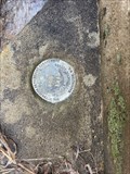
|   G 295 (FC1603) - Blount County, TN G 295 (FC1603) - Blount County, TN
in U.S. Benchmarks A vertical control disk set in the abutment of a small bridge. Very easy to find and close parking at the nearby church. posted by:  Team Geologynut Team Geologynut location: Tennessee date approved: 02/23/2023 last visited: never |
 view gallery view gallery NE4.7 km NE4.7 km
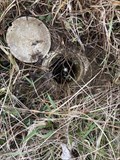
| D 295 (FC1606) - Blount County, TN in U.S. Benchmarks A stainless steel rod in a large grassy triangle very close to a Tennessee Historical Marker. Safe parking at the nearby store. posted by: Team Geologynut location: Tennessee date approved: 02/23/2023 last visited: never |
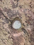 view gallery view gallerySE5.3 km | H 295 (FC1602) - Blount County, TN in U.S. Benchmarks An easy to find vertical control disk in a small outcrop. Safe parking is about 350ft south of mark. DO NOT park on the road!! This is the road to The Dragon and there's alway motorcycles and exotic cars screaming down this road! posted by: Team Geologynut location: Tennessee date approved: 02/23/2023 last visited: never |
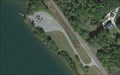 view gallery view gallerySE5.5 km |  Harrison Branch Boat Ramp - Blount County, Tennessee Harrison Branch Boat Ramp - Blount County, Tennessee
in Boat Ramps Two lane ramp access for the Little Tennessee River. posted by: Team Geologynut location: Tennessee date approved: 06/21/2019 last visited: never |
 view gallery view gallery NW5.8 km NW5.8 km
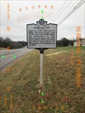
|  Norwood Inn - 1E 50 - Greenback, TN Norwood Inn - 1E 50 - Greenback, TN
in Tennessee Historical Markers Norwood Inn historical marker located on US 411 in Greenback TN posted by: Team Geologynut location: Tennessee date approved: 01/17/2019 last visited: 06/13/2019 |
 view gallery view gallery W6.3 km W6.3 km
|  Old British Sentinal Old British Sentinal
in Military Installations Fort Loudon - Founded in the early 1700's - this location was used as a fort in the fight against the indians. posted by:  ThePesters4 ThePesters4 location: Tennessee date approved: 03/03/2006 last visited: never |
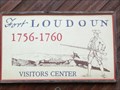 view gallery view galleryW6.4 km |  "FORT LOUDOUN" Tennessee, USA "FORT LOUDOUN" Tennessee, USA
in Historic Forts First English fort west of the Appalachian / Great Smokey Mountains, Eastern USA. posted by: Nevada Desert Rat location: Tennessee date approved: 06/09/2007 last visited: 01/14/2019 |
 view gallery view gallerySE6.4 km | J 295 (FC1601) - Blount County, TN in U.S. Benchmarks This NGS stainless steel rod is at a pull-off so parking is close. posted by: Team Geologynut location: Tennessee date approved: 02/23/2023 last visited: never |
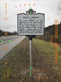 view gallery view galleryNW6.6 km | Militia Springs - 1F 17 - Greenback, TN in Tennessee Historical Markers Militia Springs historical marker located on US 411 in Greenback TN posted by: Team Geologynut location: Tennessee date approved: 01/17/2019 last visited: never |
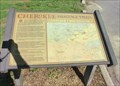
 view gallery view gallery S6.8 km S6.8 km
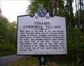
| TENASEE CHEROKEE VILLAGE ~ 1F 36 in Tennessee Historical Markers N35 31.964 W084 06.308 posted by: Better Half location: Tennessee date approved: 11/01/2007 last visited: 03/18/2013 |
 view gallery view galleryS6.8 km |  Tennessee ~ First known use of the State Name Tennessee ~ First known use of the State Name
in First of its Kind First known use of Tennessee's State name in the current form. N35 31.964 W084 06.308 posted by: Better Half location: Tennessee date approved: 11/01/2007 last visited: 03/18/2013 |
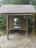
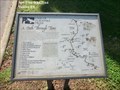
 view gallery view galleryNW7.6 km |  Morganton Branch - East Lakeshore National Recreation Trail - Greenback, TN, USA Morganton Branch - East Lakeshore National Recreation Trail - Greenback, TN, USA
in Scenic Hikes The posted coordinates take you to a large parking area with very clean restrooms (Wildcat Point). This is the South terminus of the East Lakeshore National Recreation Trail. posted by: Team Geologynut location: Tennessee date approved: 08/24/2015 last visited: 01/04/2019 |
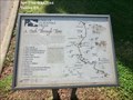
 view gallery view galleryNW7.6 km |  Morganton Branch (South Trailhead) - East Lakeshore Trail - Greenback, TN Morganton Branch (South Trailhead) - East Lakeshore Trail - Greenback, TN
in Hiking and walking trailheads Morganton Branch Trailhead of the East Lakeshore Trail in Greenback, Tennessee. posted by: Team Geologynut location: Tennessee date approved: 07/03/2019 last visited: never |
 view gallery view galleryW7.6 km |  Cherokee Heritage Trails Tsalagi Usdi Nvnohi - Vonore TN Cherokee Heritage Trails Tsalagi Usdi Nvnohi - Vonore TN
in Wagon Roads and Trails Cherokee Heritage Trails (Tsalagi Usdi Nvnohi) wind through the mountains of North Carolina, Tennessee, and Georgia, in the heart of Cherokee homelands that once encompassed more than 140,000 square miles posted by: Don.Morfe location: Tennessee date approved: 10/29/2020 last visited: 09/24/2021 |
 view gallery view galleryW7.6 km |  Cherokee Heritage Trails Tsalagi Usdi Nvnohi - Vonore TN Cherokee Heritage Trails Tsalagi Usdi Nvnohi - Vonore TN
in Signs of History Cherokee Heritage Trails (Tsalagi Usdi Nvnohi) wind through the mountains of North Carolina, Tennessee, and Georgia, in the heart of Cherokee homelands that once encompassed more than 140,000 square miles. posted by: Don.Morfe location: Tennessee date approved: 10/29/2020 last visited: 09/24/2021 |
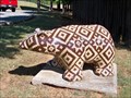 view gallery view galleryW7.6 km |  Sequoyah museum bear - Vonore, Tennessee Sequoyah museum bear - Vonore, Tennessee
in Bear Statues This beautiful bear was found outside the Sequoyah Museum in Vonore, TN. posted by: GT.US location: Tennessee date approved: 09/08/2010 last visited: never |
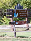 view gallery view galleryW7.6 km |  Sequoyah Birthplace Museum - Vonore, Tennessee Sequoyah Birthplace Museum - Vonore, Tennessee
in Trail of Tears The Sequoyah Birthplace museum is a stop on the Trail of Tears National Historic Trail. posted by: GT.US location: Tennessee date approved: 09/08/2010 last visited: never |
 view gallery view galleryW7.6 km | The Tennessee Overhill Experience-From Furs to Factories - Vonore TN in Signs of History From the beginning of the eighteenth century until the American Revolution, Cherokee hunters and trappers traded tens of thousands of animal pelts for manufactured goods imported by licensed British traders. posted by: Don.Morfe location: Tennessee date approved: 10/29/2020 last visited: 09/24/2021 |
 view gallery view galleryW7.6 km | Unicoi Turnpike Trail A Path Through Time - Vonore TN in Signs of History The path now known as the Unicoi Turnpike Trail has existed for over 1,000 years. The earliest European maps of the area note the trail as a connector between Cherokee Territories and the coastal ports of Charleston and Savannah. posted by: Don.Morfe location: Tennessee date approved: 10/29/2020 last visited: 09/24/2021 |
 view gallery view galleryW7.6 km | Unicoi Turnpike Trail A Path Through Time - Vonore TN in Wagon Roads and Trails The path now known as the Unicoi Turnpike Trail has existed for over 1,000 years. The earliest European maps of the area note the trail as a connector between Cherokee Territories and the coastal ports of Charleston and Savannah. posted by: Don.Morfe location: Tennessee date approved: 10/29/2020 last visited: 09/24/2021 |
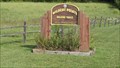
 view gallery view galleryNW7.7 km |  Craigs Chapel AME Zion Church - Greenback, TN Craigs Chapel AME Zion Church - Greenback, TN
in U.S. National Register of Historic Places The historic Craigs Chapel AME Zion Church and Cemetery in Greenback, TN are listed on the NRHP. posted by: ggmorton location: Tennessee date approved: 06/08/2021 last visited: never |
 view gallery view galleryNW7.7 km |  Craigs Chapel AME Zion Church - Greenback, TN Craigs Chapel AME Zion Church - Greenback, TN
in Wikipedia Entries The historic Craigs Chapel AME Zion Church and Cemetery in Greenback, TN are listed on the NRHP. posted by: ggmorton location: Tennessee date approved: 06/08/2021 last visited: never |
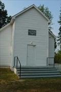 view gallery view galleryNW7.7 km |  Craigs Chapel AME Zion Church - Greenback, TN Craigs Chapel AME Zion Church - Greenback, TN
in Underground Railroad Sites Craigs Chapel AME Zion Church in Greenback, TN is a known Underground Railroad location. posted by: ggmorton location: Tennessee date approved: 06/08/2021 last visited: never |
 view gallery view galleryNW7.7 km |  Craigs Chapel AME Zion Church - Greenback, TN Craigs Chapel AME Zion Church - Greenback, TN
in This Old Church The historic Craigs Chapel AME Zion Church in rural Greenback, TN was built in 1896 and is on the NRHP. This location is now apparently being used by the New Covenant Missionary Baptist Church with services on Sunday at 10 AM and 6 PM. posted by: ggmorton location: Tennessee date approved: 06/09/2021 last visited: never |
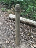 view gallery view galleryNW7.7 km | Wildcat Spur - East Lakeshore Trail System - Greenback, TN in Hiking and walking trailheads Where the Wildcat Spur branches off from the Morganton Branch. posted by: Team Geologynut location: Tennessee date approved: 07/03/2019 last visited: never |
|