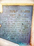
 view gallery view gallery S24.9 km S24.9 km
|   At Navajo Springs At Navajo Springs
in Arizona Historical Markers An Arizona Historical Marker on the east-bound entrance ramp to I-40, near the Navajo Travel Center. posted by:  leadhiker leadhiker location: Arizona date approved: 06/09/2011 last visited: never |
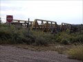
 view gallery view galleryS25.1 km |  Subway - I-40 at Kerr McGee Road, Chambers, AZ Subway - I-40 at Kerr McGee Road, Chambers, AZ
in Subway Restaurants This Subway restaurant is part of the Navajo Travel Center, on Kerr-McGee Road and I-40, in Chambers, Arizona. posted by:  The Snowdog The Snowdog location: Arizona date approved: 03/08/2020 last visited: never |
 view gallery view gallery SE26.7 km SE26.7 km
|  1923 Bridge over Rio Puerco in Sanders 1923 Bridge over Rio Puerco in Sanders
in Route 66 - The Mother Road This bridge was in operation from 1923 and carried the traffic of Route 66 over the Rio Puerco back in the day. posted by: TravisGood location: Arizona date approved: 01/13/2008 last visited: 10/31/2019 |
 view gallery view gallery E28.2 km E28.2 km
|  Querino Canyon Bridge - Historic Route 66 - Apache County, Arizona, USA. Querino Canyon Bridge - Historic Route 66 - Apache County, Arizona, USA.
in Truss Bridges Querino Canyon Bridge a listed NRHP structure - A deck truss bridge over Querino Canyon, that carried the 1930s to 1960s alignment of US-66 over the canyon between Houck, & Sanders in Arizona. posted by: veritas vita location: Arizona date approved: 02/26/2018 last visited: 03/02/2018 |
 view gallery view galleryE28.2 km | Querino Canyon Bridge - Route 66 - Apache County, Arizona, USA. in Route 66 - The Mother Road Querino Canyon Bridge a listed structure on the National Register of Historic Places - A deck truss bridge over Querino Canyon, that carried the 1930s to 1960s alignment of US-66 over the canyon between Houck, & Sanders in Arizona. posted by: veritas vita location: Arizona date approved: 02/25/2018 last visited: 03/02/2018 |
 view gallery view galleryE28.2 km |  Querino Canyon Bridge - Houck, Apache County, Arizona, USA. Querino Canyon Bridge - Houck, Apache County, Arizona, USA.
in U.S. National Register of Historic Places Querino Canyon Bridge a listed structure on the National Register of Historic Places - A deck truss bridge over Querino Canyon, that carried the 1930s to 1960s alignment of US-66 over the canyon between Houck, & Sanders in Arizona. posted by: veritas vita location: Arizona date approved: 02/28/2018 last visited: 03/02/2018 |
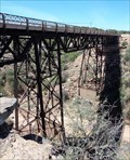 view gallery view galleryE28.2 km |  Historic Route 66 - Querino Canyon Bridge - Apache County, Arizona, USA. Historic Route 66 - Querino Canyon Bridge - Apache County, Arizona, USA.
in National Scenic Byways Querino Canyon Bridge a listed structure on the National Register of Historic Places - A deck truss bridge over Querino Canyon, that carried the 1930s to 1960s alignment of US-66 over the canyon between Houck, & Sanders in Arizona. posted by: veritas vita location: Arizona date approved: 02/26/2018 last visited: 03/02/2018 |
 view gallery view galleryE31.7 km |  Interstate 40 Westbound ~ Elevation 6000 Feet Interstate 40 Westbound ~ Elevation 6000 Feet
in Elevation Signs This Elevation Sign is located just east of Interstate Highway 40, Exit 346 at the point where you are passing through the 6000 foot level just west of Houck, Arizona. posted by: brwhiz location: Arizona date approved: 09/07/2012 last visited: 06/07/2016 |
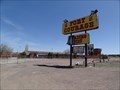 view gallery view galleryE33.8 km | Fort Courage Trading Post - Houck, AZ in Route 66 - The Mother Road Abandoned kitschy trading post on Route 66 in Houck, Arizona posted by: Wallyum location: Arizona date approved: 05/24/2021 last visited: 04/15/2017 |
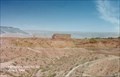
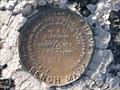 view gallery view gallery SW35.7 km SW35.7 km
|  USGS VS 6, Petrified Forest National Park, AZ USGS VS 6, Petrified Forest National Park, AZ
in U.S. Benchmarks This Bench mark disk is cemented into a rock next to the sidewalk between the Painted Desert Inn Museum and the edge of the Painted Desert. posted by: QuesterMark location: Arizona date approved: 07/12/2007 last visited: 10/15/2020 |
 view gallery view gallerySW35.9 km |  Painted Desert Bat Box ~ Petrified Forest NP, AZ Painted Desert Bat Box ~ Petrified Forest NP, AZ
in Bat Boxes A back to back bat box outside the Painted Desert Inn, on the rim of the Painted Desert inside the Petrified Forest National Park. posted by: childofatom location: Arizona date approved: 03/11/2024 last visited: never |
 view gallery view gallerySW35.9 km |  Painted Dessert - Satellite Oddity - Navajo, Arizona, USA. Painted Dessert - Satellite Oddity - Navajo, Arizona, USA.
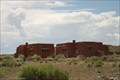
in Satellite Imagery Oddities The Painted Desert Inn - National Historic Landmark, located at Kachina Point, is the Visitor Center, Museum & Viewing Point for the 'Painted Desert' it can also viewed on Virtual Globetrotter. Located in Navajo, Arizona. posted by: veritas vita location: Arizona date approved: 11/20/2014 last visited: 10/15/2020 |
 view gallery view gallerySW35.9 km | Historic Route 66 - Painted Dessert Inn - Navajo, Arizona, USA.[ in National Scenic Byways The Painted Desert Inn - National Historic Landmark, located at Kachina Point, in the Petrified Forest National Park. The Inn once served food and lodging as a respite for travellers along, 'Route 66' in Navajo, Arizona. posted by: veritas vita location: Arizona date approved: 06/16/2014 last visited: 10/15/2020 |
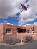
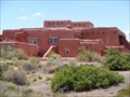 view gallery view gallerySW35.9 km |  Painted Dessert Inn - Navajo, Arizona, USA. Painted Dessert Inn - Navajo, Arizona, USA.
in Wikipedia Entries The Painted Desert Inn - National Historic Landmark, located at Kachina Point, in the Petrified Forest National Park. The Inn once served food and lodging as a respite for travellers along, 'Route 66' in Navajo, Arizona. posted by: veritas vita location: Arizona date approved: 06/16/2014 last visited: 10/15/2020 |
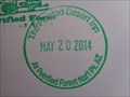 view gallery view gallerySW35.9 km |  The Painted Desert Inn - Arizona, USA. The Painted Desert Inn - Arizona, USA.
in NPS Passport Cancellation Stations The Painted Desert Inn - National Historic Landmark, located at Kachina Point, in the Petrified Forest National Park. The Inn once served as a respite for travellers along historic Route 66 in Arizona. posted by: veritas vita location: Arizona date approved: 06/15/2014 last visited: 10/15/2020 |
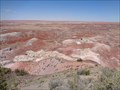 view gallery view gallerySW35.9 km |  Painted Dessert - Visitor Attraction - Navajo, Arizona, USA. Painted Dessert - Visitor Attraction - Navajo, Arizona, USA.
in Official Local Tourism Attractions The Painted Desert Inn - National Historic Landmark, located at Kachina Point, is the visitor center & viewing point for the 'Painted Desert' The Inn once served food and lodging as a respite for travellers along, 'Route 66' in Navajo, Arizona. posted by: veritas vita location: Arizona date approved: 11/22/2014 last visited: 10/15/2020 |
 view gallery view gallerySW35.9 km | The Painted Dessert Inn - Navajo, Arizona, USA. in Route 66 - The Mother Road The Painted Desert Inn - National Historic Landmark, located at Kachina Point, in the Petrified Forest National Park. The Inn once served food and lodging as a respite for travellers along, 'Route 66' in Navajo, Arizona. posted by: veritas vita location: Arizona date approved: 06/21/2014 last visited: 10/15/2020 |
 view gallery view gallerySW35.9 km | Painted Desert Inn - Arizona in Satellite Imagery Oddities This Inn was built in the 1920's with petrified wood. In 1976 it was added to the National Register of Historic Places.
Please see private message. posted by: Max and 99 location: Arizona date approved: 03/26/2023 last visited: never |
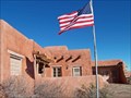 view gallery view gallerySW35.9 km | Painted Desert Inn, Arizona in U.S. National Register of Historic Places Once a hotel on Route 66, now part of Petrified Forest National Park posted by: Bernd das Brot Team location: Arizona date approved: 01/11/2007 last visited: 10/15/2020 |
 view gallery view gallerySW35.9 km |  Painted Desert Back Country Hiking Trail, Arizona Painted Desert Back Country Hiking Trail, Arizona
in Long Distance Hiking Trails Trailhead for dayhikes and overnight hikes in the Painted Desert posted by: Bernd das Brot Team location: Arizona date approved: 01/06/2007 last visited: 10/31/2019 |
 view gallery view gallerySW35.9 km |  CCC Project at the Painted Desert Inn - Petrified Forest NP, AZ CCC Project at the Painted Desert Inn - Petrified Forest NP, AZ
in Civilian Conservation Corps Construction of the Inn took 3 years and employed 100's of men in the CCC in the late 1930's. Special elements include Pueblo Revival architecture, murals, stained glass, and hammered-tin chandeliers. The Inn also was a Harvey House from 1947-1963. posted by: DopeyDuck location: Arizona date approved: 04/19/2010 last visited: 10/31/2019 |
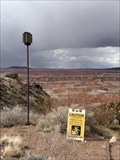
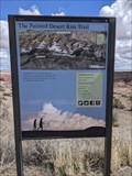 view gallery view gallerySW35.9 km |  Painted Desert Rim Trailhead - PFNP - Arizona Painted Desert Rim Trailhead - PFNP - Arizona
in Hiking and walking trailheads This easy walking trail will take viewers along the rim from Tawa Point to the Painted Desert Inn, and back again if you choose. posted by: Max and 99 location: Arizona date approved: 04/30/2023 last visited: never |
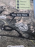 view gallery view gallerySW35.9 km |  You are Here at The Painted Desert Rim Trail - PFNP - Holbrook, AZ You are Here at The Painted Desert Rim Trail - PFNP - Holbrook, AZ
in 'You Are Here' Maps You are Here is posted on The Painted Desert Rim Trail informational sign at the trailhead. posted by: Max and 99 location: Arizona date approved: 04/30/2023 last visited: never |
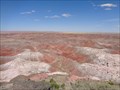
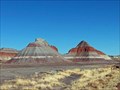
 view gallery view gallerySW36.4 km | Petrified Forest National Park - Holbrook AZ in Wikipedia Entries Petrified Forest National Park is an American national park in Navajo and Apache counties in northeastern Arizona. Named for its large deposits of petrified wood, the park covers about 346 square miles (900 square kilometers). posted by: Don.Morfe location: Arizona date approved: 02/18/2022 last visited: 02/18/2022 |
 view gallery view gallerySW36.4 km | Petrified Forest National Park - Holbrook AZ in Satellite Imagery Oddities Petrified Forest National Park is an American national park in Navajo and Apache counties in northeastern Arizona. Named for its large deposits of petrified wood, the park covers about 346 square miles (900 square kilometers). posted by: Don.Morfe location: Arizona date approved: 02/18/2022 last visited: 02/18/2022 |
|