 view gallery view gallery SW9.2 km SW9.2 km
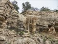
|  ") Sandia Man Cave - Bernalillo, NM Sandia Man Cave - Bernalillo, NM
in Cave Entrances (Natural) Sandia Cave near Bernalillo, NM posted by:  TerraViators TerraViators location: New Mexico date approved: 04/12/2016 last visited: 07/23/2009 |
 view gallery view gallery N10 km N10 km
|  Formerly San Felipes Casino now Black Mesa Casino - San Felipe NM Formerly San Felipes Casino now Black Mesa Casino - San Felipe NM
in Casinos Formerly San Felipes Casino now Black Mesa Casino is located at 25 Hagon Road, San Felipe, New Mexico 87001. I visited there on May 24, 2005. posted by:  Don.Morfe Don.Morfe location: New Mexico date approved: 01/23/2024 last visited: 01/24/2024 |
 view gallery view gallery W10.1 km W10.1 km
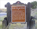
|  Las Placitas Las Placitas
in New Mexico Historical Markers Las Placitas OSHM marker. posted by: kingbee location: New Mexico date approved: 07/18/2010 last visited: 11/11/2011 |
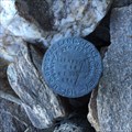
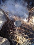 view gallery view galleryW10.3 km |  1/4 section benchmark 1/4 section benchmark
in U.S. Benchmarks 1/4 section benchmark posted by: kingbee location: New Mexico date approved: 01/19/2012 last visited: 01/03/2012 |
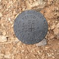 view gallery view gallerySW12.1 km | Survey Marker Corner T12N R4E Sections 11, 12, 14 & 13 in U.S. Benchmarks US General Land Office Survey 1924 survey disk on pipe posted by: ZenGuru location: New Mexico date approved: 03/24/2015 last visited: never |
 view gallery view gallery NW12.7 km NW12.7 km
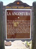
| La Angostura in New Mexico Historical Markers Algodones strategic twin of the Reconquesta of New Mexico is Santa Ana Pueblo. posted by: leadhiker location: New Mexico date approved: 10/12/2011 last visited: 02/23/2018 |
 view gallery view galleryNW12.7 km |  La Angostura - Bernalillo, New Mexico, USA. La Angostura - Bernalillo, New Mexico, USA.
in Route 66 - The Mother Road Historic Route 66 & El Camino Real are National Scenic Byways. This location is on 'Historic Route 66' (1926 to 1937 Alignment) the Santa Fe loop, at La Angostura Historic Marker near Bernalillo, New Mexico. posted by: veritas vita location: New Mexico date approved: 08/04/2014 last visited: 05/20/2014 |
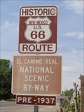
 view gallery view galleryNW12.7 km |  El Camino Real - La Angostura - Bernalillo, New Mexico. El Camino Real - La Angostura - Bernalillo, New Mexico.
in National Scenic Byways El Camino Real a National Scenic Byway, first travelled by Don Juan de Onate in 1598. This location is on 'Historic Route 66' (1926 to 1937 Alignment) at La Angostura Historic Marker near Bernalillo, New Mexico. posted by: veritas vita location: New Mexico date approved: 07/16/2014 last visited: 05/20/2014 |
 view gallery view gallerySW12.7 km | Survey Marker NE Corner Section 14 T12N R4E in U.S. Benchmarks US General Land Office Survey 1916 survey disk on pipe surrounded by rock cairn posted by: ZenGuru location: New Mexico date approved: 02/21/2015 last visited: never |
 view gallery view gallery S13.5 km S13.5 km
|  Capulin Snowplay Area -- Sandia Mtns. nr Albuquerque NM Capulin Snowplay Area -- Sandia Mtns. nr Albuquerque NM
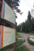
in Cross Country Ski Trailheads The Capulin Campground and Snowplay area in the Sandia Mountains above Albuquerque offers cross-country skiing trail and other snow play options in winter. posted by: Benchmark Blasterz location: New Mexico date approved: 08/20/2014 last visited: 10/12/2014 |
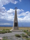 view gallery view galleryN13.5 km | The Mormon Battalion in New Mexico Historical Markers This monument is well worth the short side trip off I-25 to take a look. posted by: leadhiker location: New Mexico date approved: 10/13/2011 last visited: 07/05/2015 |
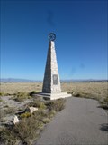 view gallery view galleryN13.5 km | Mormon Battalion - Sandoval County, New Mexico in New Mexico Historical Markers At the end of a lonely frontage road. posted by: Go Boilers! location: New Mexico date approved: 10/22/2011 last visited: 10/13/2015 |
 view gallery view galleryN13.5 km |  Mormon Battalion, Mexican–American War, Sandoval County, New Mexico, USA Mormon Battalion, Mexican–American War, Sandoval County, New Mexico, USA
in Specific Wars Monuments and Memorials At the end of a lonely frontage road. posted by: Go Boilers! location: New Mexico date approved: 07/24/2012 last visited: 08/24/2019 |
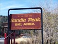 view gallery view galleryS14 km |  Sandia Peak Ski Area - New Mexico Sandia Peak Ski Area - New Mexico
in Winter Sports Locations The Sandia Peak Ski Area is a great place to ski! posted by: GT.US location: New Mexico date approved: 11/19/2007 last visited: 08/04/2003 |
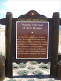 view gallery view galleryW15 km | Women Veterans of New Mexico in New Mexico Historical Markers A New Mexico Historic Women Marker posted by: leadhiker location: New Mexico date approved: 10/12/2011 last visited: never |
 view gallery view gallerySW15.1 km | Ellis Cross Country Ski Trailhead -- Sandia Mtns nr Albuquerque NM in Cross Country Ski Trailheads In winter, the Ellis Campground picnic area hiking trail in the Sandia Mountains is available for cross country skiing. posted by: Benchmark Blasterz location: New Mexico date approved: 08/20/2014 last visited: 08/23/2014 |
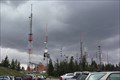 view gallery view gallerySW15.3 km |  Sandia Crest Tower Farm -- Albuquerque NM Sandia Crest Tower Farm -- Albuquerque NM
in Radio and Television Transmitter Towers Ride the Sandia Peak Tramway to this tower farm (and all the tourist stuff nearby) posted by: Benchmark Blasterz location: Texas date approved: 04/10/2017 last visited: 05/21/2017 |
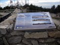 view gallery view gallerySW15.3 km |  Parnoramic Views and Migratory Flyway, Sandia Crest, NM Parnoramic Views and Migratory Flyway, Sandia Crest, NM
in Flora and Fauna Information Signs This sign is located at the top of Sandia Crest, near the gift shop. posted by: Queens Blessing location: New Mexico date approved: 11/19/2011 last visited: 07/23/2009 |
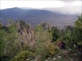 view gallery view gallerySW15.3 km | Sandia Crest Scenic Byway, NM in National Scenic Byways This is a New Mexico Scenic & Historic Byway and National Forest Scenic Byway. posted by: Queens Blessing location: New Mexico date approved: 11/19/2011 last visited: 12/07/2019 |
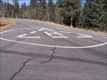 view gallery view gallerySW15.3 km |  Sandia Crest Helicopter Pad - New Mexico Sandia Crest Helicopter Pad - New Mexico
in Helicopter Landing Pads This Helicopter pad is located near the lookout at the Sandia Crest. posted by: GT.US location: New Mexico date approved: 04/26/2008 last visited: 05/21/2017 |
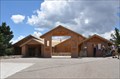
 view gallery view gallery SE15.3 km SE15.3 km
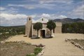
|  San Francisco de Asis Catholic Church - Golden, NM San Francisco de Asis Catholic Church - Golden, NM
in Country Churches Wikipedia says 37 is population of Golden, but only 11 live in town. posted by: YoSam. location: New Mexico date approved: 12/31/2019 last visited: never |
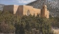 view gallery view gallerySE15.3 km | San Francisco de Asis - Golden, NM in Roman Catholic Churches Wikipedia says 37 is population of Golden, but only 11 live in town. posted by: YoSam. location: New Mexico date approved: 01/01/2020 last visited: never |
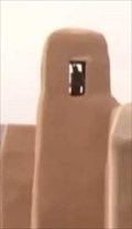 view gallery view gallerySE15.3 km |  San Francisco de Asis Bell Tower- Golden, NM San Francisco de Asis Bell Tower- Golden, NM
in Bell Towers Wikipedia says 37 is population of Golden, but only 11 live in town. posted by: YoSam. location: New Mexico date approved: 12/31/2019 last visited: never |
 view gallery view gallerySW15.3 km |  Sandia Crest House ~ Elevation 10,678 feet Sandia Crest House ~ Elevation 10,678 feet
in Elevation Signs This Elevation Sign is at the front entrance to Sandia Crest House at the high point of the Sandia Crest Scenic Byway east of Albuquerque, New Mexico. posted by: brwhiz location: New Mexico date approved: 11/07/2012 last visited: 05/21/2017 |
 view gallery view gallerySW15.3 km | Sandia Crest National Scenic Byway ~ Sandia Crest House in National Scenic Byways Sandia Crest House is the highest point on the Sandia Crest National Scenic Byway, the highest Scenic Byway in the Southwest. posted by: brwhiz location: New Mexico date approved: 11/18/2012 last visited: 05/21/2017 |
|