 view gallery view gallery E10.3 km E10.3 km
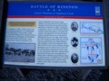
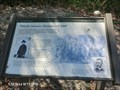
|   Battle of Kinston Foster's Position on Southwest Creek — Foster's Raid — Lenoir County, North Carolina Battle of Kinston Foster's Position on Southwest Creek — Foster's Raid — Lenoir County, North Carolina
in Civil War Discovery Trail Sites Marker is near Kinston, North Carolina, in Lenoir County. Marker is at the intersection of Richlands Road (U.S. 258) and Stroud's Corner Road on Richlands Road. posted by:  Countrydragon Countrydragon location: North Carolina date approved: 01/01/2010 last visited: 01/08/2010 |
 view gallery view gallery NW13 km NW13 km
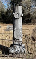
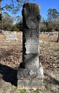
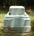
|  John C. Broadhurst - Seven Springs United Methodist Church Cemetery - Seven Springs, NC John C. Broadhurst - Seven Springs United Methodist Church Cemetery - Seven Springs, NC
in Woodmen of the World Grave Markers/Monuments A Woodmen of the World monument in Seven Springs, North Carolina. posted by:  dream chaser dream chaser location: North Carolina date approved: 06/11/2023 last visited: 06/11/2023 |
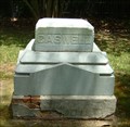
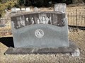 view gallery view galleryNW13 km | Grady - Seven Springs United Methodist Church Cemetery - Seven Springs, NC in Woodmen of the World Grave Markers/Monuments A Woodmen of the World monument in Seven Springs United Methodist Church Cemetery, Seven Springs, NC. posted by: dream chaser location: North Carolina date approved: 06/11/2023 last visited: never |
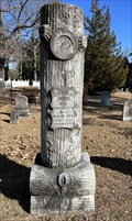 view gallery view galleryNW13 km | Geo. Gaylor Quinn - Seven Springs United Methodist Church Cemetery - Seven Springs, NC in Woodmen of the World Grave Markers/Monuments A Woodmen of the World monument in Seven Springs, North Carolina. posted by: dream chaser location: North Carolina date approved: 06/11/2023 last visited: never |
 view gallery view galleryNW13 km | M. W. UZZELL - Seven Springs United Methodist Church Cemetery - Seven Springs, NC in Woodmen of the World Grave Markers/Monuments A Woodmen of the World monument in Seven Springs, North Carolina. posted by: dream chaser location: North Carolina date approved: 06/11/2023 last visited: never |
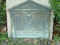
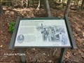
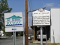 view gallery view galleryNW13 km |  Battle Of Whitehall - F-44 Battle Of Whitehall - F-44
in North Carolina Historical Markers Located on NC-55 at Main Street, Seven Springs, NC posted by: Countrydragon location: North Carolina date approved: 01/06/2010 last visited: 09/12/2013 |
 view gallery view gallery N15.1 km N15.1 km
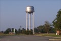
|  Municipal Water Tank - La Grange, NC Municipal Water Tank - La Grange, NC
in Water Towers Municipal water tank for La Grange, in Lenoir County, NC posted by: LJParr location: North Carolina date approved: 08/11/2010 last visited: never |
 view gallery view gallery NE15.4 km NE15.4 km
|  Ray E Eubanks-Kinston NC Ray E Eubanks-Kinston NC
in Medal Of Honor Resting Places World War II Medal of Honor Recipient for action at Noemfoor Island, Dutch New Guinea on July 23, 1944. He was killed in action. He is buried in Westview Cemetery, Kinston, NC in Division H, Lot 136. posted by: Don.Morfe location: North Carolina date approved: 11/04/2017 last visited: 12/19/2021 |
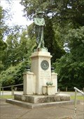 view gallery view galleryNE16.1 km | Lenoir County Civil War Monument, Kinston, North Carolina in American Civil War Monuments and Memorials The Lenoir County Monument has traveled around the county a bit. It is currently located at the Richard Caswell/C.S.S. Neuse State Historic Site. posted by: showbizkid location: North Carolina date approved: 07/03/2006 last visited: 04/19/2023 |
 view gallery view galleryNE16.1 km | Confederate Ironclad Ram C.S.S. Neuse, Kinston, North Carolina in Civil War Discovery Trail Sites The remain of a Confederate ironclad ram ship, the C.S.S. Neuse, are displayed at this historic site in Kinston. The posted coordinates will take you to interpretive signage outside the visitors center. Guided tours are held throughout the day when the center is open. posted by: showbizkid location: North Carolina date approved: 07/03/2006 last visited: 01/08/2010 |
 view gallery view galleryNE16.3 km |  Richard Caswell Richard Caswell
in Grave of a Famous Person Richard Caswell was a North Carolina patriot, Colonial officer and the first Constitutional Governor of North Carolina. He is buried in Kinston, North Carolina. posted by: showbizkid location: North Carolina date approved: 06/30/2006 last visited: 06/24/2006 |
 view gallery view galleryNE16.3 km | Brigadier General Richard Caswell in American Revolutionary War Veteran Graves Richard Caswell was a North Carolina patriot, Colonial officer and the first Constitutional Governor of North Carolina. He is buried in Kinston, North Carolina. posted by: showbizkid location: North Carolina date approved: 06/29/2006 last visited: 06/24/2006 |
 view gallery view galleryNE16.4 km | Richard Caswell Historic Marker in North Carolina Historical Markers This is a 1919 North Carolina State Historic Marker located very near the newer 1938 Highway Marker for Caswell. posted by: showbizkid location: North Carolina date approved: 06/30/2006 last visited: 06/24/2006 |
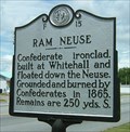 view gallery view galleryNE16.4 km | Ram Neuse, Marker F-15 in North Carolina Historical Markers The Ram Neuse or CSS Neuse is a confederate ironclad ram, destroyed by the Confederates to avoid Union capture. The remains were salvaged in 1963 and are now on public display near this marker. posted by: showbizkid location: North Carolina date approved: 07/07/2006 last visited: 01/08/2010 |
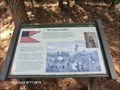
 view gallery view galleryNE16.4 km | Wessells' Advance—December 14, 1862-Harriet's Chapel Battlefield Park - Kinston NC in American Civil War Monuments and Memorials Gen. John Gray Foster’s long blue line slowly marched north from Southwest Creek toward the Confederate line. The Confederates, behind a formidable line of earthworks protected by a swamp in their front, braced for the Union assault. posted by: Don.Morfe location: North Carolina date approved: 04/20/2023 last visited: 04/18/2023 |
 view gallery view galleryNE16.4 km | The Center of the Confederate Line-Harriet's Chapel Battlefield Park - Kinston NC in American Civil War Monuments and Memorials Harriet’s Chapel stood in the center of the Confederate line. A heavily wooded wetland stood in front of the line. Behind it was the Neuse River. Three regiments of infantry and two batteries of artillery held this portion of the Confederate line. posted by: Don.Morfe location: North Carolina date approved: 04/20/2023 last visited: 04/18/2023 |
 view gallery view galleryNE16.4 km | Wessells' Advance—December 14, 1862-Harriet's Chapel Battlefield Park - Kinston NC in U.S. Civil War Sites Gen. John Gray Foster’s long blue line slowly marched north from Southwest Creek toward the Confederate line. The Confederates, behind a formidable line of earthworks protected by a swamp in their front, braced for the Union assault. posted by: Don.Morfe location: North Carolina date approved: 10/11/2020 last visited: 10/01/2021 |
 view gallery view galleryNE16.4 km | The Center of the Confederate Line-Harriet's Chapel Battlefield Park - Kinston NC in U.S. Civil War Sites Harriet’s Chapel stood in the center of the Confederate line. A heavily wooded wetland stood in front of the line. Behind it was the Neuse River. Three regiments of infantry and two batteries of artillery held this portion of the Confederate line. posted by: Don.Morfe location: North Carolina date approved: 10/11/2020 last visited: 10/01/2021 |
 view gallery view galleryNE16.4 km | The Action in the Swamp-Harriet's Chapel Battlefield Park - Kinston NC in U.S. Civil War Sites A large swamp separated the advancing Union army and the Confederate defenders one-half mile north. The swamp slowed the Union advance and provided cover for the Confederates. posted by: Don.Morfe location: North Carolina date approved: 10/11/2020 last visited: 10/01/2021 |
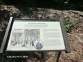
 view gallery view galleryNE16.4 km |  Wessells' Advance—December 14, 1862-Harriet's Chapel Battlefield Park - Kinston NC Wessells' Advance—December 14, 1862-Harriet's Chapel Battlefield Park - Kinston NC
in Battlefields Gen. John Gray Foster’s long blue line slowly marched north from Southwest Creek toward the Confederate line. The Confederates, behind a formidable line of earthworks protected by a swamp in their front, braced for the Union assault. posted by: Don.Morfe location: North Carolina date approved: 04/21/2023 last visited: 04/18/2023 |
 view gallery view galleryNE16.4 km | The Center of the Confederate Line-Harriet's Chapel Battlefield Park - Kinston NC in Battlefields Harriet’s Chapel stood in the center of the Confederate line. A heavily wooded wetland stood in front of the line. Behind it was the Neuse River. Three regiments of infantry and two batteries of artillery held this portion of the Confederate line. posted by: Don.Morfe location: North Carolina date approved: 04/21/2023 last visited: 04/18/2023 |
 view gallery view galleryNE16.4 km | The Action in the Swamp-Harriet's Chapel Battlefield Park - Kinston NC in Battlefields A large swamp separated the advancing Union army and the Confederate defenders one-half mile north. The swamp slowed the Union advance and provided cover for the Confederates. posted by: Don.Morfe location: North Carolina date approved: 04/21/2023 last visited: 04/18/2023 |
 view gallery view galleryNE16.4 km | Richard Caswell, Marker F-2 in North Carolina Historical Markers Richard Caswell was North Carolina's first constitutional Governor posted by: showbizkid location: North Carolina date approved: 06/30/2006 last visited: 01/08/2010 |
 view gallery view galleryNE16.4 km | The Union Artillery-Harriet's Chapel Battlefield Park - Kinston NC in Battlefields Twenty-four guns of the 3rd New York Artillery supported Gen. Wessells’ infantry as they advanced through the swamp toward the Confederate line. The overwhelming firepower of Union infantry and artillery forced the Confederates to abandon the line. posted by: Don.Morfe location: North Carolina date approved: 04/21/2023 last visited: 04/18/2023 |
 view gallery view galleryNE16.4 km | The Union Artillery-Harriet's Chapel Battlefield Park - Kinston NC in U.S. Civil War Sites Twenty-four guns of the 3rd New York Artillery supported Gen. Wessells’ infantry as they advanced through the swamp toward the Confederate line. The overwhelming firepower of Union infantry and artillery forced the Confederates to abandon the line. posted by: Don.Morfe location: North Carolina date approved: 10/11/2020 last visited: 10/01/2021 |
|