 view gallery view gallery N2.1 km N2.1 km
|   Parksville Lake Parksville Lake
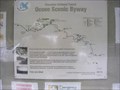
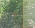
in 'You Are Here' Maps Cherokee National Forest
Ocoee Scenic Byway posted by:  Better Half Better Half location: Tennessee date approved: 09/15/2007 last visited: 07/13/2013 |
 view gallery view gallery NW3.7 km NW3.7 km
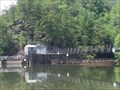
|  The Ocoee Gondolier - Ocoee, TN The Ocoee Gondolier - Ocoee, TN
in Independent Pizza Restaurants Located between the town of Ocoee and Lake Ocoee on Hwy 64. posted by: fatcat161 location: Tennessee date approved: 10/07/2009 last visited: 08/14/2011 |
 view gallery view galleryNW4.2 km |  River Maze River Maze
in Outdoor Mazes River Maze posted by: Better Half location: Tennessee date approved: 09/15/2007 last visited: 08/14/2011 |
 view gallery view gallery NE4.8 km NE4.8 km
|  Chilhowee Mountain Overlook - 2280ft Chilhowee Mountain Overlook - 2280ft
in Elevation Signs Chilhowee Mountain Overlook is on the east side of Chilhowee Mountain. It looks out on Big Frog Mountain, Fort Mountain, Sugarloaf Mountain and other sights. posted by: fatcat161 location: Tennessee date approved: 10/07/2009 last visited: never |
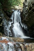 view gallery view galleryNE7.6 km |  Rock Creek Falls Rock Creek Falls
in Waterfalls Ocoee/Benton, TN: Small waterfalls along the Scenic Spur Trail #78 posted by: The Yoyo Man location: Tennessee date approved: 12/11/2006 last visited: 02/19/2007 |
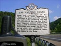 view gallery view galleryNE7.7 km |  THE HALFWAY HOUSE 2A 51 THE HALFWAY HOUSE 2A 51
in Tennessee Historical Markers THE HALFWAY HOUSE posted by: Better Half location: Tennessee date approved: 09/09/2007 last visited: 06/23/2010 |
 view gallery view galleryNW8.5 km |  McDonalds – US 64, Ocoee, TN McDonalds – US 64, Ocoee, TN
in McDonald's Restaurants McDonalds at the Exxon Express on US 64 at US 411 in Ocoee, TN. posted by: Lat34North location: Tennessee date approved: 07/08/2008 last visited: 08/17/2008 |
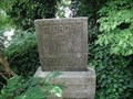
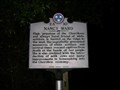 view gallery view galleryN10 km | Nancy Ward - 2A 10 in Tennessee Historical Markers Located near Benton, TN. posted by: Better Half location: Tennessee date approved: 06/26/2008 last visited: 10/02/2008 |
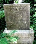
 view gallery view gallery SW13 km SW13 km
| 2A26 Georgia~Tennessee State Line in Tennessee Historical Markers Two sided marker on the TN~GA state line on US 411. posted by: Sprinterman location: Tennessee date approved: 03/12/2009 last visited: 09/14/2008 |
 view gallery view gallerySW13 km |  TN/GA state line on US 411, Tennga, GA. TN/GA state line on US 411, Tennga, GA.
in Border Crossings There is a stone marker (hidden in the bushes) here at the Tennessee Georgia border, as well as the standard DOT sign. posted by: Lat34North location: Tennessee date approved: 07/10/2008 last visited: 05/30/2009 |
 view gallery view gallerySW13 km |  GA / TN State Border - US411 GA / TN State Border - US411
in U.S. Historic Survey Stones and Monuments Stone monument (hidden in the bushes) marking the Tennessee Georgia border. There is also standard DOT sign about 3 feet east of the stone marker, so it is easy to find.
posted by: Lat34North location: Georgia date approved: 07/07/2008 last visited: 07/04/2008 |
 view gallery view gallerySW13 km |  GA / TN State Border - US411 GA / TN State Border - US411
in Public Land Survey Marks Stone monument (hidden in the bushes) marking the Tennessee Georgia border. There is also standard DOT sign about 3 feet east of the stone marker, so it is easy to find. posted by: Lat34North location: Georgia date approved: 04/23/2010 last visited: 07/04/2008 |
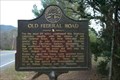 view gallery view gallerySW13.4 km |  105-10, Old Federal Road 105-10, Old Federal Road
in Georgia Historical Markers Tennga, GA: 105-10 Old Federal Road State Historical Marker
Located on U.S. 411 at the south edge of Tennga, GA in Murray county.
posted by: The Yoyo Man location: Georgia date approved: 12/11/2006 last visited: 09/13/2008 |
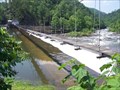
 view gallery view gallery E14.3 km E14.3 km
|  Ocoee Dam No. 2 - Polk County, TN Ocoee Dam No. 2 - Polk County, TN
in Wikipedia Entries The building of this dam started in 1911 and finished in 1913. It was put on the National Register of Historic Places in 1979. posted by: debbado location: Tennessee date approved: 07/10/2009 last visited: 03/27/2023 |
 view gallery view galleryE14.3 km |  Ocoee Hydroelectric Plant No. 2 - Polk County, TN Ocoee Hydroelectric Plant No. 2 - Polk County, TN
in U.S. National Register of Historic Places The building of this dam started in 1911 and finished in 1913. It was put on the National Register of Historic Places in 1979. posted by: debbado location: Tennessee date approved: 07/08/2009 last visited: 03/27/2023 |
 view gallery view galleryE14.3 km |  Ocoee Dam No. 2 - Polk County, TN Ocoee Dam No. 2 - Polk County, TN
in Water Dams The building of this dam started in 1911 and finished in 1913. It was put on the National Register of Historic Places in 1979. posted by: debbado location: Tennessee date approved: 07/08/2009 last visited: 03/27/2023 |
 view gallery view gallery S16.3 km S16.3 km
|  Sumac Creek Shooting Range (Cisco, GA) Sumac Creek Shooting Range (Cisco, GA)
in Shooting Ranges Cisco, GA: Sumac Creek Shooting Range located off Old Hwy 2 in the Cohutta Wildlife Management Area in the Chattahoochee National Forest. posted by: The Yoyo Man location: Georgia date approved: 12/11/2006 last visited: never |
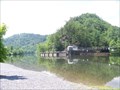
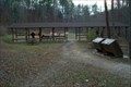
 E16.9 km |  Tanasi Trail System Tanasi Trail System
in Mountain Bike Trailheads 30 miles of trail begin at the white water center where the 1996 Olympic Canoe and Kayak Slalom competitions were held. posted by:  AB4N AB4N location: Tennessee date approved: 08/19/2005 last visited: 06/25/2009 |
 view gallery view galleryE16.9 km |  Ocoee Blue Holes Ocoee Blue Holes
in Swimming Holes Blue Holes located near the Ocoee Whitewater Center posted by: AB4N location: Tennessee date approved: 08/26/2005 last visited: never |
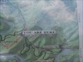
 view gallery view galleryE16.9 km | You Are Here - Old Copper Road Trail in 'You Are Here' Maps Located in the Ocoee Whitewater Center on US Hwy 64. posted by: debbado location: Tennessee date approved: 07/09/2009 last visited: 06/25/2009 |
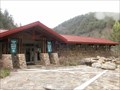 view gallery view galleryE17.1 km |  Ocoee Whitewater Center 1996 Olympics - Cherokee National Forest, TN Ocoee Whitewater Center 1996 Olympics - Cherokee National Forest, TN
in Modern Olympic Venues The Ocoee Whitewater Center was developed to host the Whitewater Canoeing and Kayaking events for the 1996 Olympics in Atlanta, GA. posted by: cldisme location: Tennessee date approved: 04/12/2009 last visited: 07/13/2013 |
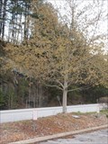 view gallery view galleryE17.1 km |  James Davidson - Cherokee National Forest, TN James Davidson - Cherokee National Forest, TN
in Dedicated Trees A simple dedication for James Davidson (1982-1996). posted by: cldisme location: Tennessee date approved: 06/11/2009 last visited: 07/13/2013 |
 view gallery view galleryE18.3 km | You Are Here - Boyd Gap in 'You Are Here' Maps Located in the Boyd Gap scenic overlook area off U.S. Hwy. 64. posted by: debbado location: Tennessee date approved: 07/09/2009 last visited: 06/25/2009 |
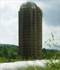 view gallery view gallerySW21.1 km |  US 411-Cisco, Georgia US 411-Cisco, Georgia
in Solitary Silos A double located not far south of the Tennessee-Georgia state line. posted by: Sprinterman location: Georgia date approved: 09/13/2008 last visited: 09/13/2008 |
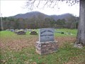 view gallery view gallery SE21.4 km SE21.4 km
|  Mount Liberty Cemetery - McCaysville, GA Mount Liberty Cemetery - McCaysville, GA
in Churchyard Cemeteries This cemetery is behind the Mount Liberty Baptist Church on Mountain View Road. posted by: debbado location: Georgia date approved: 11/26/2009 last visited: 11/25/2009 |
|