 view gallery view gallery S27 km S27 km
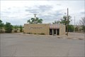
|   USPS Magdalena NM 87825-9998 USPS Magdalena NM 87825-9998
in U.S. Post Offices a little post office in Magdalena, New Mexico posted by:  kallehaugerne kallehaugerne location: New Mexico date approved: 07/19/2018 last visited: never |
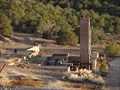
 view gallery view galleryS27 km |  Magdalena Santa Fe Depot - Magdalena, New Mexico Magdalena Santa Fe Depot - Magdalena, New Mexico
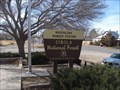
in Train Stations/Depots This beautiful building is located off of the main highway running through town, so most people will never see this site. posted by:  gparkes gparkes location: New Mexico date approved: 12/22/2010 last visited: never |
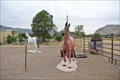 view gallery view galleryS27 km |  Horses in Magdalena, NM Horses in Magdalena, NM
in Fiberglass Horses Two fiberglass horses outside Otero's gem & mineral rock shop. posted by: kallehaugerne location: New Mexico date approved: 06/05/2020 last visited: never |
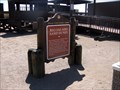
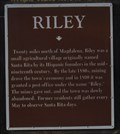 view gallery view galleryS27 km |  Riley - Magdalena, New Mexico Riley - Magdalena, New Mexico
in New Mexico Historical Markers This marker is found in Magdalena. posted by: gparkes location: New Mexico date approved: 12/21/2010 last visited: never |
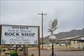 view gallery view galleryS27 km |  Otereo's Gem and minerals rockshop - Magdalena, NM Otereo's Gem and minerals rockshop - Magdalena, NM
in Mom and Pop Rock Shops Otero's rock and mineral shop in the little town Magdalena in southern New Mexico. posted by: kallehaugerne location: New Mexico date approved: 05/31/2020 last visited: never |
 view gallery view galleryS27 km |  Magdalena Ranger Station - Cibola National Forest - Magdalena, New Mexico Magdalena Ranger Station - Cibola National Forest - Magdalena, New Mexico
in Ranger Stations This National Forest Service Ranger Station can be found in Magdalena. posted by: gparkes location: New Mexico date approved: 12/21/2010 last visited: never |
 view gallery view galleryS27 km |  Smokey Bear - Magdalena Ranger Station - Magdalena, New Mexico Smokey Bear - Magdalena Ranger Station - Magdalena, New Mexico
in Smokey Bear Sign Sightings Smokey can be seen here along US Highway 60. posted by: gparkes location: New Mexico date approved: 12/23/2010 last visited: never |
 view gallery view galleryS27 km | Kelly, New Mexico in New Mexico Historical Markers The marker for this ghost town can be found on the turn off to Kelly. posted by: gparkes location: New Mexico date approved: 12/21/2010 last visited: 01/22/2011 |
 view gallery view galleryS27.2 km | Smokey at the firestation, Magdalena, NM in Smokey Bear Sign Sightings Smokey the Bear sign outside the firestation of Magdalena. posted by: kallehaugerne location: New Mexico date approved: 07/18/2018 last visited: never |
 view gallery view galleryS27.4 km | Magdalena - Magdalena, New Mexico in New Mexico Historical Markers There are three markers in Magdalena, this is the only for the town itself. The two others are for ghost towns around the town. posted by: gparkes location: New Mexico date approved: 12/21/2010 last visited: 04/02/2017 |
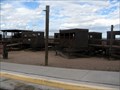
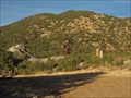 view gallery view galleryS31.5 km |  Kelly Mine - Kelly, New Mexico Kelly Mine - Kelly, New Mexico
in Mines The Kelly Mine grounds are free to explore, after paying a fee to the property owners. posted by: gparkes location: New Mexico date approved: 12/24/2010 last visited: never |
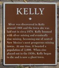
 view gallery view galleryS31.5 km |  Kelly, New Mexico Kelly, New Mexico
in Ghost Towns Kelly was founded around a silver mine. Later, Sherwin Williams bought the mine, as zinc carbonate was mined for paint. As the minerals ran out, so did the residents. posted by: gparkes location: New Mexico date approved: 12/21/2010 last visited: never |
 view gallery view galleryS31.5 km |  Kelly Mine - Magdalea, New Mexico Kelly Mine - Magdalea, New Mexico
in Rock-Hounding The Kelly Mine grounds are free to explore, after paying a fee to the property owners. posted by: gparkes location: New Mexico date approved: 12/24/2010 last visited: never |
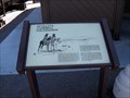
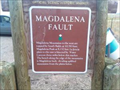 view gallery view gallery SE36.7 km SE36.7 km
| Magdalena Fault in New Mexico Historical Markers An OSHM sign. posted by: kingbee location: New Mexico date approved: 08/01/2010 last visited: 05/27/2020 |
 view gallery view gallery E38.3 km E38.3 km
|  Walking Sands Rest Area, Interstate I-25, New Mexico -Southbound Walking Sands Rest Area, Interstate I-25, New Mexico -Southbound
in Highway Rest Areas This is the southbound rest area on Interstate 25 in Socorro County. posted by: Queens Blessing location: New Mexico date approved: 10/17/2011 last visited: 09/02/2013 |
 view gallery view galleryE38.3 km |  Seviletta Wildlife Refuge, Socorro County, NM - Southbound Seviletta Wildlife Refuge, Socorro County, NM - Southbound
in Signs of History This sign provides the history behind the Seviletta Wildlife Refuge. posted by: Queens Blessing location: New Mexico date approved: 10/16/2011 last visited: 09/02/2013 |
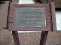 view gallery view galleryE38.3 km |  Tribute to Randall G. Sanders, Socorro County, NM Tribute to Randall G. Sanders, Socorro County, NM
in Citizen Memorials This simple tribute is located in the southbound "Walking Sands" Rest area on Interstate 25. posted by: Queens Blessing location: New Mexico date approved: 10/16/2011 last visited: 09/02/2013 |
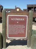 view gallery view galleryE38.3 km | ACOMILLA - Historical Marker in New Mexico Historical Markers ACOMILLA Historical Marker & Rest Stop I-25 New Mexico posted by: GEO*Trailblazer 1 location: New Mexico date approved: 05/04/2007 last visited: 05/31/2018 |
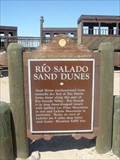 view gallery view galleryE38.3 km | RIO SALADO SAND DUNES - Historical Marker in New Mexico Historical Markers RIO SALADO Sand Dunes & Rest Area I-25 New Mexico posted by: GEO*Trailblazer 1 location: New Mexico date approved: 05/04/2007 last visited: 06/27/2013 |
 view gallery view galleryE38.5 km | Acomilla - Northbound- New Mexico in New Mexico Historical Markers This is a twin to the SOUTHBOUND "Acomilla" sign. posted by: Queens Blessing location: New Mexico date approved: 11/19/2011 last visited: 02/15/2013 |
 view gallery view galleryE38.5 km | Rio Salado Sand Dunes - Northbound, New Mexico in New Mexico Historical Markers This is a twin to the SOUTHBOUND "Rio Salado Sand Dunes" sign posted by: Queens Blessing location: New Mexico date approved: 11/19/2011 last visited: 10/07/2012 |
 view gallery view galleryE38.5 km | Seviletta Wildlife Refuge, Socorro County, NM - Northbound in Signs of History This sign provides the history behind the Seviletta Wildlife Refuge. It is a twin to the sign on the southbound side of I-25. posted by: Queens Blessing location: New Mexico date approved: 11/21/2011 last visited: 09/02/2013 |
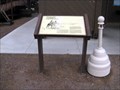
 view gallery view galleryE39.6 km |  U.S. Dept. of Interior Fish and Wildlife Service 'PT 389' U.S. Dept. of Interior Fish and Wildlife Service 'PT 389'
in U.S. Benchmarks A US Department of Interior Fish and Wildlife Service pipecap. posted by: BuckBrooke location: New Mexico date approved: 03/15/2006 last visited: never |
 view gallery view galleryE39.6 km | New Mexico-Colorado Principal Meridian in U.S. Benchmarks This is PID AI5439 INITIAL POINT, which is the disk replacing the pile of rocks that was used as the starting point for civil surveying of New Mexico and southern Colorado posted by: BuckBrooke location: New Mexico date approved: 03/15/2006 last visited: never |
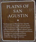 view gallery view gallery SW40.6 km SW40.6 km
| Plains of San Agustin - Socorro County, New Mexico in New Mexico Historical Markers At a pull out looking at the Very Large Array (VLA), this historic marker can be seen. posted by: gparkes location: New Mexico date approved: 12/22/2010 last visited: 05/26/2020 |
|