 view gallery view gallery E4 km E4 km
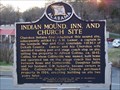
|   Indian Mound, Inn, and Church Site - Collinsville, AL Indian Mound, Inn, and Church Site - Collinsville, AL
in Alabama Historical Markers Cherokee Indians first inhabited this mound site. It became an inn in the 1840s and a Baptist Church in 1926. posted by:  hummerstation hummerstation location: Alabama date approved: 01/04/2013 last visited: never |
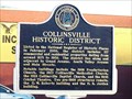 view gallery view galleryE4.2 km | Collinsville Historic District - Collinsville, AL in Alabama Historical Markers The Collinsville Historic District was listed on the National Register of Historic Places in February 2006. posted by: hummerstation location: Alabama date approved: 01/04/2013 last visited: never |
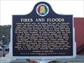 view gallery view galleryE4.3 km | Fires and Floods - Collinsville, AL in Alabama Historical Markers Collinsville burned twice and suffered annually as it was inundated with flood waters from heavy rains that rushed down Lookout Mountain causing Little Wills Creek to overflow onto Main Street. posted by: hummerstation location: Alabama date approved: 01/05/2013 last visited: never |
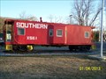 view gallery view galleryE4.3 km |  Southern Caboose X561 - Collinsville, AL Southern Caboose X561 - Collinsville, AL
in Train Cabooses Southern Caboose X561 is displayed in Veterans Park. posted by: hummerstation location: Alabama date approved: 01/07/2013 last visited: never |
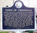 view gallery view gallery W8.4 km W8.4 km
| Town of Crossville - Crossville, AL in Alabama Historical Markers Crossville, AL, was named by James A. Copeland because of the area’s many crossroads. posted by: hummerstation location: Alabama date approved: 12/27/2014 last visited: never |
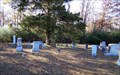
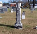 view gallery view galleryW8.4 km |  Walter M. Williams - First United Methodist Church Cemetery - Crossville, AL Walter M. Williams - First United Methodist Church Cemetery - Crossville, AL
in Woodmen of the World Grave Markers/Monuments The Walter M. Williams Woodmen of the World marker is located in the First United Methodist Church Cemetery in Crossville, AL. posted by: hummerstation location: Alabama date approved: 12/26/2014 last visited: never |
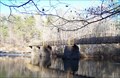
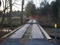 view gallery view gallery NE11.6 km NE11.6 km
|  Plank Bridge - Collinsville, AL Plank Bridge - Collinsville, AL
in Plank Roads A plank bridge in Collinsville, AL that crosses Big Willis Creek. posted by: ggmorton location: Alabama date approved: 09/30/2020 last visited: 12/22/2009 |
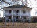
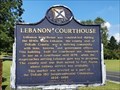 view gallery view galleryNE14.2 km |  Lebanon courthouse - Lebanon - Alabama USA Lebanon courthouse - Lebanon - Alabama USA
in Courthouses This former courthouse was used in the 19e Century and is located in Fort Payne, AL in the US. posted by: seal13 location: Alabama date approved: 01/01/2024 last visited: 09/15/2022 |
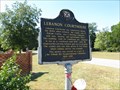 view gallery view galleryNE14.2 km | Lebanon Courthouse - Ft. Payne, Alabama in Alabama Historical Markers Marker giving the history of the former DeKalb County Courthouse, which was used until 1876 when the county seat was moved. It is now a private residence. posted by: xptwo location: Alabama date approved: 04/09/2012 last visited: 05/28/2017 |
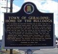 view gallery view gallery NW14.3 km NW14.3 km
| Town of Geraldine: Home of the Bulldogs - Geraldine, AL in Alabama Historical Markers Geraldine is one of those small, rural towns whose high school athletic teams always seem to be in the hunt for state titles. posted by: hummerstation location: Alabama date approved: 12/27/2014 last visited: never |
 view gallery view gallery SE18.5 km SE18.5 km
|  411 Drive in - Centre, Alabama 411 Drive in - Centre, Alabama
in Drive-In Movie Theaters The 411 is located just outside of Centre, Alabama and is open year round. See the updates below! posted by: SearchN location: Alabama date approved: 03/23/2008 last visited: 05/27/2014 |
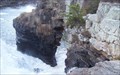
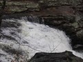 view gallery view galleryE19.2 km |  Little River Canyon Falls Little River Canyon Falls
in Waterfalls These are not the main falls in Little River Canyon, but it is a small waterfall that is off the beaten path. There is an overlook parking area near it. posted by: pixieslayer location: Alabama date approved: 12/21/2005 last visited: never |
 view gallery view gallery SW19.8 km SW19.8 km
|  Alabama City Library - Gadsden, AL Alabama City Library - Gadsden, AL
in U.S. National Register of Historic Places The Library was constructed between 1898 and 1900. posted by: hummerstation location: Alabama date approved: 05/08/2012 last visited: never |
 view gallery view galleryNW21.1 km |  High Falls Bridge - Geraldine, AL High Falls Bridge - Geraldine, AL
in Arch Bridges The High Falls Bridge was built on the stone pillars of a 1923 covered bridge. posted by: hummerstation location: Alabama date approved: 11/20/2014 last visited: never |
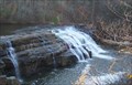 view gallery view galleryNW21.1 km | High Falls - Geraldine, AL in Waterfalls High Falls is located in High Falls Park which itself is located off AL Hwy 227 northwest of Geraldine in DeKalb County. posted by: hummerstation location: Alabama date approved: 12/05/2013 last visited: 09/19/2004 |
 view gallery view galleryNW21.1 km |  High Falls Arch - Geraldine, AL High Falls Arch - Geraldine, AL
in Natural Arches High Falls Arch is located at High Falls on Town Creek. posted by: hummerstation location: Alabama date approved: 12/07/2013 last visited: 09/19/2004 |
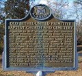 view gallery view galleryNW22.5 km | Old Bethel United Primitive Baptist Church and Cemetery - Asbury, AL in Alabama Historical Markers The Old Bethel United Primitive Baptist Church was organized by 1847 as one of the first churches on Sand Mountain. posted by: hummerstation location: Alabama date approved: 11/11/2014 last visited: never |
 view gallery view galleryNW22.5 km |  Old Bethel United Primitive Baptist Church Cemetery - Asbury, AL Old Bethel United Primitive Baptist Church Cemetery - Asbury, AL
in Worldwide Cemeteries Old Bethel United Primitive Baptist Church Cemetery is located on Old Bethel Road east of Asbury, AL. posted by: hummerstation location: Alabama date approved: 11/10/2014 last visited: never |
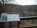 view gallery view galleryNE23.5 km |  Grace's High Falls Overlook - Little River Canyon Preserve, AL Grace's High Falls Overlook - Little River Canyon Preserve, AL
in Scenic Roadside Look-Outs This scenic vista is one of many overlooks along the rim of Alabama's Little River Canyon National Preserve.
posted by: Scooter Bill location: Alabama date approved: 07/06/2008 last visited: 06/13/2016 |
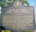 view gallery view galleryNE24 km |  Historic Marker in Fort Payne, AL Historic Marker in Fort Payne, AL
in Trail of Tears John Benge Route started in this town. posted by: 8Nuts MotherGoose location: Alabama date approved: 06/13/2007 last visited: never |
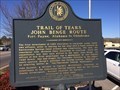 view gallery view galleryNE24 km | Trail of Tears John Benge Route Fort Payne, Alabama to Oklahoma in Alabama Historical Markers Trail of Tears John Benge Route Fort Payne, Alabama to Oklahoma posted by: dado0820 location: Alabama date approved: 04/10/2018 last visited: never |
 view gallery view galleryNE24.3 km |  Cracker Barrel in Fort Payne, AL Cracker Barrel in Fort Payne, AL
in Cracker Barrel Restaurants This Cracker Barrel restaurant is located just off I-59 at Exit 218 in Fort Payne, AL. Bus & RV Parking is Available. posted by:  Lat34North Lat34North location: Alabama date approved: 12/18/2007 last visited: 05/14/2012 |
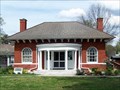
 view gallery view galleryW24.3 km |  Thomas A. Snellgrove Homestead - Boaz, AL Thomas A. Snellgrove Homestead - Boaz, AL
in Wikipedia Entries The main house of the Thomas A. Snellgrove Homestead was built in 1900. posted by: hummerstation location: Alabama date approved: 12/04/2019 last visited: never |
 view gallery view galleryW24.3 km | Snellgrove, Thomas, A., Homestead - Boaz, AL in U.S. National Register of Historic Places The main house of the Thomas A. Snellgrove Homestead was built in 1900. posted by: hummerstation location: Alabama date approved: 12/04/2019 last visited: never |
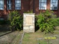 view gallery view gallerySE24.3 km |  World Wars I and II Veterans Memorial - Centre, AL World Wars I and II Veterans Memorial - Centre, AL
in Non-Specific Veteran Memorials Memorial to Cherokee County Alabama veterans of World Wars I and II. Located on the lawn of the Cherokee County Courthouse. posted by: hummerstation location: Alabama date approved: 11/03/2009 last visited: 05/27/2014 |
|