 view gallery view gallery NE1.4 km NE1.4 km
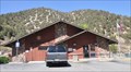
|   Mt. Baldy Lodge Lift - Mt. Baldy, CA Mt. Baldy Lodge Lift - Mt. Baldy, CA
in Aerial Lifts The coordinates are the starting point at the parking lot for the lift. posted by:  bluesnote bluesnote location: California date approved: 12/04/2013 last visited: 08/18/2019 |
 view gallery view galleryNE2.7 km |  USGS H5 7802 RESET 1955 USGS H5 7802 RESET 1955
in U.S. Benchmarks A USGS Benchmark at the desert view area of Baldy Notch. posted by: Rumpled location: California date approved: 07/29/2008 last visited: never |
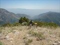
 view gallery view gallery N3.2 km N3.2 km
|  Mt. San Antonio - Mt. Baldy, CA Mt. San Antonio - Mt. Baldy, CA
in Geographic High Points The highest peak in the San Gabriel Mountains and Los Angeles County! posted by: bluesnote location: California date approved: 12/14/2013 last visited: 04/21/2015 |
 view gallery view galleryN3.2 km |  Mt. San Antonio - Mt. Baldy, CA Mt. San Antonio - Mt. Baldy, CA
in Wikipedia Entries The highest peak in the San Gabriel Mountains! posted by: bluesnote location: California date approved: 12/01/2013 last visited: 08/18/2019 |
 view gallery view galleryN3.2 km |  Mt. San Antonio, a.k.a. Mt. Baldy, California Mt. San Antonio, a.k.a. Mt. Baldy, California
in Mountain Summits Mt. San Antonio is a 10,064 foot peak in the San Gabriel Mountains in the Angeles National Forest. posted by:  showbizkid showbizkid location: California date approved: 01/24/2006 last visited: 06/25/2013 |
 view gallery view galleryN3.2 km |  Mt. San Antonio - Mt. Baldy, CA Mt. San Antonio - Mt. Baldy, CA
in Elevation Signs The highest peak in the San Gabriel Mountains! posted by: bluesnote location: California date approved: 12/05/2013 last visited: 12/05/2013 |
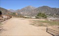
 view gallery view gallery SW3.4 km SW3.4 km
|  M. Baldy Visitor Center - Mt. Baldy, CA M. Baldy Visitor Center - Mt. Baldy, CA
in Tourist Information Centers - Visitor Centers This visitor center is located in the small town of Mt. Baldy. posted by: bluesnote location: California date approved: 12/23/2013 last visited: 12/23/2013 |
 view gallery view gallerySW3.7 km |  Mount Baldy, California 91759 Mount Baldy, California 91759
in U.S. Post Offices This Post Office is located at 6730 Mount Baldy Road in Mount Baldy, California. posted by: brwhiz location: California date approved: 12/29/2013 last visited: never |
 view gallery view gallery W4.2 km W4.2 km
| Lookout Mountain and the Speed of Light in Mountain Summits On Lookout Mountain you will find what remains of Station Antonio which played a key role in the verification of the speed of light. posted by: Carharty location: California date approved: 06/16/2006 last visited: never |
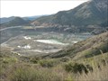
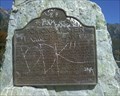 view gallery view gallerySW6.8 km |  Pomona Power Plant - Mt. Baldy, CA Pomona Power Plant - Mt. Baldy, CA
in California Historical Markers Pomona Water Power Plant historical marker. posted by: Rumpled location: California date approved: 11/07/2008 last visited: 10/20/2012 |
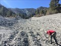 view gallery view galleryN9.5 km |  Heath Canyon - Wrightwood, CA Heath Canyon - Wrightwood, CA
in Places of Geologic Significance A nearby Landslide created a small canyon where green crystals, actinolite, can be found. posted by: bluesnote location: California date approved: 11/26/2014 last visited: 11/26/2014 |
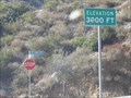 view gallery view gallery S10.5 km S10.5 km
| Mt Baldy Road - 3000 feet in Elevation Signs Mt Baldy Road - 3000 feet posted by: InGodsHands location: California date approved: 09/21/2010 last visited: never |
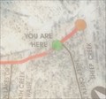 view gallery view galleryN10.6 km |  Trail Map - Wrightwood, CA Trail Map - Wrightwood, CA
in 'You Are Here' Maps A trail map along Highway 2. posted by: bluesnote location: California date approved: 11/27/2014 last visited: 11/27/2014 |
 view gallery view galleryN10.6 km | Wrightwood, CA - Elevation 6,000 in Elevation Signs An elevation sign along Highway 2. posted by: bluesnote location: California date approved: 11/25/2014 last visited: 11/25/2014 |
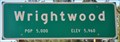
 view gallery view galleryN10.6 km |  Wrightwood, CA - Population 5,000 Wrightwood, CA - Population 5,000
in Population Signs A population sign along Highway 2. posted by: bluesnote location: California date approved: 03/12/2015 last visited: 03/12/2015 |
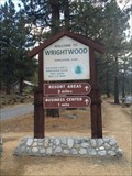
 view gallery view galleryN10.6 km |  Wrightwood, CA Wrightwood, CA
in Welcome Signs A Welcome sign along Highway 2. posted by: bluesnote location: California date approved: 11/25/2014 last visited: 11/25/2014 |
 view gallery view galleryN10.8 km | Wrightwood ~ Elevation 5960 in Elevation Signs This combination Elevation/Population sign is on the north side of Angeles Crest Highway (California 2) at the eastern city limits of Wrightwood, California. posted by: brwhiz location: California date approved: 08/23/2013 last visited: never |
 view gallery view galleryN10.8 km | Wrightwood ~ Population 5000 in Population Signs This combination Elevation/Population sign is on the north side of Angeles Crest Highway (California 2) at the eastern city limits of Wrightwood, California. posted by: brwhiz location: California date approved: 08/25/2013 last visited: never |
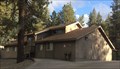 view gallery view galleryN10.8 km |  Wrightwood Public Library - Wrightwood, CA Wrightwood Public Library - Wrightwood, CA
in Libraries A public library in downtown Wrightwood. posted by: bluesnote location: California date approved: 05/27/2016 last visited: 05/27/2016 |
 view gallery view galleryN10.9 km | Wrightwood, California 92397 in U.S. Post Offices This Post Office is located at 1440 State Highway 2 in Wrightwood, California. posted by: brwhiz location: California date approved: 08/22/2013 last visited: 03/05/2016 |
 view gallery view galleryN10.9 km | Wrightwood, California in Wikipedia Entries The above coordinates are for the post office in town. posted by: bluesnote location: California date approved: 03/24/2016 last visited: 03/24/2016 |
 view gallery view galleryN10.9 km |  Wrightwood, California Wrightwood, California
in American Guide Series The above coordinates are for the post office in town. posted by: bluesnote location: California date approved: 03/25/2016 last visited: 03/25/2016 |
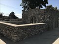
 view gallery view galleryS12.2 km |  Antonio Dam Helipad 62A Antonio Dam Helipad 62A
in Helicopter Landing Pads This helipad, placed for use by the Army Corps of Engineers, is located at the western end of the San Antonio Flood Control Dam in the foothills above the San Gabriel Valley. posted by: brwhiz location: California date approved: 12/31/2013 last visited: never |
 view gallery view galleryS12.2 km |  San Antonio Dam San Antonio Dam
in Water Dams San Antonio Dam was constructed to aid in flood control for the city of Claremont. posted by: CraigsOutside location: California date approved: 03/01/2011 last visited: 04/17/2011 |
 view gallery view galleryS12.7 km |  Upland Waiting Station - Upland, CA Upland Waiting Station - Upland, CA
in Satellite Imagery Oddities The ruins of the historic waiting station in Upland, CA. posted by: saopaulo1 location: California date approved: 04/03/2020 last visited: never |
|