 view gallery view gallery W19.3 km W19.3 km
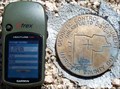
|   Perry Mesa, Hohokam Nation, Arizona (042) Perry Mesa, Hohokam Nation, Arizona (042)
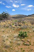
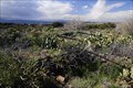
in New World Ancient Evidence Located on the north east area of Perry Mesa. posted by:  CoinsAndPins CoinsAndPins location: Arizona date approved: 12/08/2009 last visited: 06/15/2016 |
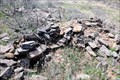 view gallery view galleryW19.5 km | Perry Mesa, Hohokam Nation, Arizona (044) in New World Ancient Evidence Located on the north east area of Perry Mesa not far from the Rosalie Mine. posted by: CoinsAndPins location: Arizona date approved: 12/08/2009 last visited: 11/19/2020 |
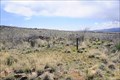 view gallery view galleryW19.6 km | Perry Mesa, Hohokam Nation, Arizona (045) in New World Ancient Evidence Located on the north east area of Perry Mesa. posted by: CoinsAndPins location: Arizona date approved: 12/08/2009 last visited: 01/28/2018 |
 view gallery view gallery SW20.1 km SW20.1 km
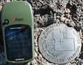
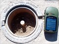
|  1OI2 - Height Modernization Survey Station 1OI2 - Height Modernization Survey Station
in U.S. Benchmarks PID AJ3737
STATE/COUNTY AZ/MARICOPA
USGS QUAD HUMBOLDT MTN (1978) posted by: Arizona Ranger Team location: Arizona date approved: 04/06/2011 last visited: never |
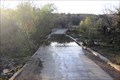 view gallery view gallerySW21.7 km |  Highway 24 Seven Springs Water Crossing Highway 24 Seven Springs Water Crossing
in Bridgeless Water Crossings Located along Highway 24 at the north end of the CCC Campground in Arizona. posted by: CoinsAndPins location: Arizona date approved: 05/21/2008 last visited: 10/25/2008 |
 view gallery view gallerySW21.7 km |  CCC Camp, Seven Springs, Arizona CCC Camp, Seven Springs, Arizona
in Civilian Conservation Corps Located north of Scotsdale, Arizona along highway 24. posted by: CoinsAndPins location: Arizona date approved: 05/21/2008 last visited: 12/08/2017 |
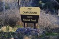 view gallery view gallerySW21.7 km |  CCC Campgrounds CCC Campgrounds
in Campgrounds Located on Highway 24 north of Scottsdale, Arizona posted by: CoinsAndPins location: Arizona date approved: 05/21/2008 last visited: 12/08/2017 |
 view gallery view gallery S23 km S23 km
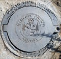
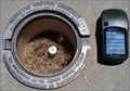
| 1NJ1 - Height Modernization Survey Station in U.S. Benchmarks PID AJ3738
STATE/COUNTY AZ/MARICOPA
USGS QUAD HUMBOLDT MTN (1978) posted by: Arizona Ranger Team location: Arizona date approved: 05/15/2011 last visited: never |
 view gallery view galleryW27.2 km | Pueblo Pato, Hohokam Nation, Perry Mesa, Arizona (046) in New World Ancient Evidence Located on Perry Mesa near the Perry Tank Canyon. posted by: CoinsAndPins location: Arizona date approved: 12/08/2009 last visited: 01/28/2018 |
 view gallery view galleryW27.4 km | Pueblo Pato, Hohokam Nation, Perry Mesa, Arizona (047) in New World Ancient Evidence Located on the Perry Mesa on the south edge of Perry Tank Canyon posted by: CoinsAndPins location: Arizona date approved: 12/08/2009 last visited: 01/26/2018 |
 view gallery view galleryS28.2 km | 1MJ3 - Height Modernization Survey Station in U.S. Benchmarks PID AJ3735
STATE/COUNTY AZ/MARICOPA
USGS QUAD HUMBOLDT MTN (1978) posted by: Arizona Ranger Team location: Arizona date approved: 05/15/2011 last visited: never |
 view gallery view galleryS30.7 km | 1LL1 - Height Modernization Survey Station in U.S. Benchmarks PID AJ3712
STATE/COUNTY AZ/MARICOPA
USGS QUAD HORSESHOE DAM (1978) posted by: Arizona Ranger Team location: Arizona date approved: 05/17/2011 last visited: never |
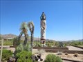 view gallery view galleryS32 km |  Corn Maiden Dancer Kachina - Carefree, AZ Corn Maiden Dancer Kachina - Carefree, AZ
in Statues of Religious Figures This is a 39' tall statue of the Corn Maiden Kachina from the Hopi culture. posted by: rjmcdonough1 location: Arizona date approved: 06/29/2017 last visited: never |
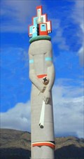 view gallery view galleryS32 km |  World's Largest Kachina Doll World's Largest Kachina Doll
in Ginormous Everyday Objects Iin the residential community of Tonto Hills, stands a 39-foot-tall Kachina doll, unquestionably the world's largest. posted by: ILuvAZ location: Arizona date approved: 05/24/2013 last visited: 06/27/2017 |
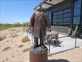 view gallery view galleryS32 km |  Raven Man - Carefree, AZ Raven Man - Carefree, AZ
in Figurative Public Sculpture The Raven Man stands outside the Raven's View bar in the Tonto Hills above Carefree, Arizona. posted by: rjmcdonough1 location: Arizona date approved: 06/28/2017 last visited: never |
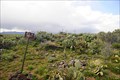
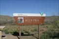 view gallery view galleryW32.5 km |  Agua Fria National Monument & BLM Land - Cordes Junction, AZ Agua Fria National Monument & BLM Land - Cordes Junction, AZ
in Public Access Lands The Agua Fria National Monument contains more than 400 archaeological sites, spanning some 2,000 years of human history. The area is BLM land and is open to the public as recreation land, including camping, hunting, and off-roading. posted by:  DopeyDuck DopeyDuck location: Arizona date approved: 04/10/2009 last visited: 12/20/2017 |
 view gallery view galleryS33.2 km | 1LM2 - Height Modernization Survey Station in U.S. Benchmarks PID AJ3713
STATE/COUNTY AZ/MARICOPA
USGS QUAD BARTLETT DAM (1964) posted by: Arizona Ranger Team location: Arizona date approved: 05/17/2011 last visited: never |
 view gallery view galleryS33.3 km | 1LK4 - Height Modernization Survey Station in U.S. Benchmarks PID AJ3741
STATE/COUNTY AZ/MARICOPA
USGS QUAD WILDCAT HILL (1981) posted by: Arizona Ranger Team location: Arizona date approved: 05/15/2011 last visited: never |
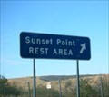 view gallery view galleryW33.6 km |  I-17 - Sunset Point Rest Area - Arizona I-17 - Sunset Point Rest Area - Arizona
in Highway Rest Areas Sunset Point Rest Area. A welcome respite from the long days travel. posted by: geobwong2k location: Arizona date approved: 09/06/2011 last visited: 08/12/2019 |
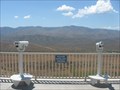 view gallery view galleryW33.6 km |  Sunset Point I-17, Arizona Sunset Point I-17, Arizona
in Coin-Op Binoculars A beautiful view from a popular rest area on I-17 in Arizona. posted by: desert georangers location: Arizona date approved: 07/22/2010 last visited: 09/07/2018 |
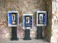 view gallery view galleryW33.6 km |  Sunset Point Rest Area Pay Phone Sunset Point Rest Area Pay Phone
in Payphones Three payphones are located side-by-side-by-side at the Sunset Point Rest Area on Highway 17 in Arizona. posted by: Fremont Claassens location: Arizona date approved: 07/09/2006 last visited: 09/07/2018 |
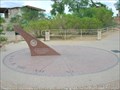 view gallery view galleryW33.6 km |  Sunset Point Rest Area Sundial Sunset Point Rest Area Sundial
in Sundials A memorial sundial located in the Sunset Point Rest Area on Highway 17 in Arizona. posted by: Fremont Claassens location: Arizona date approved: 07/09/2006 last visited: 02/17/2018 |
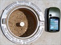
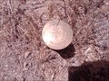 view gallery view gallerySW34.4 km | T7NR3E in U.S. Benchmarks Benchmark location dated 1917 in the middle of nowhere Tonto National Forest, New River, Az posted by: johnlvining location: Arizona date approved: 06/14/2011 last visited: never |
 view gallery view gallery NE34.4 km NE34.4 km
|  Tonto Natural Bridge State Park Tonto Natural Bridge State Park
in Scenic Hikes Tonto Natural Bridge State Park in Arizona has the largest diversity of wildlife in the state, with some of the most scenic landscape posted by: b.b.wolf location: Arizona date approved: 07/21/2009 last visited: 11/15/2015 |
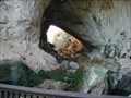
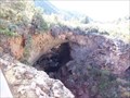 view gallery view galleryNE34.4 km |  Tonto Natural Bridge Tonto Natural Bridge
in Natural Arches This is the largest natural travertine bridge in the world. posted by: TerryDad2 location: Arizona date approved: 12/09/2007 last visited: 10/19/2019 |
|