 view gallery view gallery SW1.3 km SW1.3 km
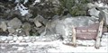
|   Bay Tree Spring - Hwy 243 CA Bay Tree Spring - Hwy 243 CA
in Natural Springs This spring is on Hwy 243 about halfway between Idyllwild and Banning. posted by:  PeterNoG PeterNoG location: California date approved: 02/11/2008 last visited: 01/29/2008 |
 view gallery view gallery W2.6 km W2.6 km
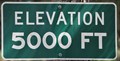
|  Palms to Pines Scenic Byway ~ Elevation 5000 Feet Palms to Pines Scenic Byway ~ Elevation 5000 Feet
in Elevation Signs This Elevation Sign is on the south side of the Palms to Pines Scenic Byway (California Highway 243) at Mellor Ranch Road, about 11 miles south of Banning California. posted by: brwhiz location: California date approved: 12/09/2012 last visited: 02/04/2013 |
 view gallery view gallery S3.4 km S3.4 km
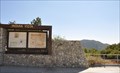
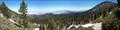
|  Palms to Pines Scenic Byway ~ Indian Vista Palms to Pines Scenic Byway ~ Indian Vista
in National Scenic Byways Indian Vista on the Palms to Pines Scenic Byway is located on the south side of the Palms to Pines Scenic Byway (California Highway 243), about 14 3/4 miles south of Banning, California. posted by: brwhiz location: California date approved: 12/09/2012 last visited: 02/03/2014 |
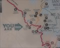 view gallery view galleryS3.4 km |  Indian Vista Indian Vista
in 'You Are Here' Maps You Are Here at Indian Vista on the Palms to Pines Scenic Byway (California Highway 243), about 14 3/4 miles south of Banning, California. posted by: brwhiz location: California date approved: 12/09/2012 last visited: 07/19/2022 |
 view gallery view gallery SE7.1 km SE7.1 km
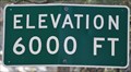
| Palms to Pines Scenic Byway ~ Elevation 6000 Feet in Elevation Signs This Elevation Sign is on the west side of the Palms to Pines Scenic Byway (California Highway 243) at Stonewood Canyon Road, about 20 miles south of Banning, California. posted by: brwhiz location: California date approved: 12/09/2012 last visited: 02/04/2013 |
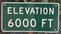 view gallery view gallerySE9.2 km | Palms to Pines Scenic Byway ~ Elevation 6000 Feet in Elevation Signs This Elevation Sign is on the west side of the Palms to Pines Scenic Byway (California Highway 243) just north of Lakeview Drive, about 21.7 miles south of Banning, California. posted by: brwhiz location: California date approved: 12/09/2012 last visited: 02/04/2013 |
 view gallery view gallery N9.3 km N9.3 km
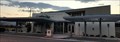
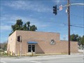
|  Cabazon Community Library - Cabazon, CA Cabazon Community Library - Cabazon, CA
in Libraries The Cabazon Community Library in Cabazon, CA. posted by: saopaulo1 location: California date approved: 09/30/2017 last visited: 11/24/2017 |
 view gallery view gallery E9.3 km E9.3 km
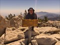
|  Santa Rosa and San Jacinto Mountains - San Jacinto Peak Santa Rosa and San Jacinto Mountains - San Jacinto Peak
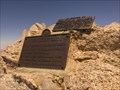
in National Parks of the World San Jacinto Peak is the second highest peak in Southern California. It has the second steepest elevation gain in the nation. posted by: TerryDad2 location: California date approved: 08/28/2006 last visited: 05/20/2015 |
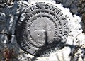
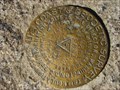 view gallery view galleryE9.3 km |  San Jacinto Peak Triangulation disk San Jacinto Peak Triangulation disk
in U.S. Benchmarks Benchmark DX5119
This benchmark can be found at the second highest point in southern California at an elevation of 10,834 feet above sea level. posted by:  Moag Ohana Moag Ohana location: California date approved: 01/08/2008 last visited: 11/16/2017 |
 view gallery view galleryE9.3 km |  Highest Point in Riverside County, Mt San Jacinto Highest Point in Riverside County, Mt San Jacinto
in Geographic High Points Mt San Jacinto is the Highest Point in Riverside County posted by: Rumpled location: California date approved: 01/10/2010 last visited: 05/20/2015 |
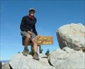 view gallery view galleryE9.3 km |  Mt. San Jacinto, California Mt. San Jacinto, California
in Mountain Summits Mt. San Jacinto is a 10,834 foot peak above Palm Springs. It is the second highest peak in Southern California. posted by: showbizkid location: California date approved: 01/27/2006 last visited: 05/20/2015 |
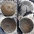 view gallery view galleryE9.3 km | SAN JACINTO Azimuth Disk w/ Triangulation Station Disks - PID DX5119 in U.S. Benchmarks Azimuth Mark Disk for Triangulation Station "SAN JACINTO" along with all three benchmark disks for the station itself. posted by: Vader! location: California date approved: 06/29/2009 last visited: 05/20/2015 |
 view gallery view galleryE9.3 km |  SAN JACINTO 1898 1923 SET 1954 - California SAN JACINTO 1898 1923 SET 1954 - California
in Azimuth Benchmarks Azimuth Mark Disk mentioned in 1954 Documented History for Triangulation Station "SAN JACINTO" (PID DX5119), along with all three benchmark disks for the station itself. posted by: Vader! location: California date approved: 06/29/2009 last visited: 05/20/2015 |
 view gallery view galleryE10 km | Miller Peak in Mountain Summits Miller Peak on the East flank of San Jacinto Peak in Mount San Jacinto State Park. The peak is above the 10400 contour, so the elevation is 10400+ posted by: Rumpled location: California date approved: 09/19/2008 last visited: never |
 view gallery view galleryN10 km |  LOOM Lodge 915 - Cabazon, CA LOOM Lodge 915 - Cabazon, CA
in Moose Lodges and Centers This is the San Gorgonio Pass Moose Lodge. It's on Broadway at Main St just west of I-10 Exit 106 in Cabazon CA. posted by: PeterNoG location: California date approved: 03/04/2009 last visited: 12/16/2014 |
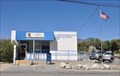 view gallery view galleryN10 km |  Cabazon, California 92230 Cabazon, California 92230
in U.S. Post Offices This Post Office is located at 50360 Ramona Road in Cabazon, California. posted by: brwhiz location: California date approved: 10/02/2013 last visited: 02/19/2016 |
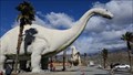
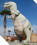 view gallery view galleryN10.3 km |  T-Rex - Cabazon, CA T-Rex - Cabazon, CA
in Dinosaur Statues One of two dinosaur statues located at the Cabazon Dinosaurs in Cabazon, California. posted by: geobwong2k location: California date approved: 03/23/2009 last visited: 01/15/2023 |
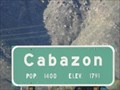 view gallery view galleryN10.3 km | Cabazon CA 1791 feet - I-10 westbound in Elevation Signs This elevation/population sign for Cabazon, California is on I-10 westbound about 1000 feet east of the Cabazon exit. posted by: PeterNoG location: California date approved: 02/18/2011 last visited: 06/02/2011 |
 view gallery view galleryN10.3 km |  Cabazon CA - 1,400 - I-10 westbound Cabazon CA - 1,400 - I-10 westbound
in Population Signs This population/elevation sign for Cabazon, California is on I-10 westbound about 1000 feet east of the Cabazon exit. posted by: PeterNoG location: California date approved: 02/19/2011 last visited: 03/31/2013 |
 view gallery view galleryN10.3 km |  Cabazon, California Cabazon, California
in Wikipedia Entries Cabazon is best-known for the two giant concrete dinosaurs that sit just north of Interstate 10 at the east edge of town. posted by: brwhiz location: California date approved: 03/26/2011 last visited: 02/01/2016 |
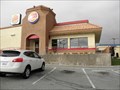 view gallery view galleryN10.3 km |  Burger King - Seminole Dr - Cabazon, CA Burger King - Seminole Dr - Cabazon, CA
in Burger King Restaurants This Burger King is right at the Cabazon Exit of the I-10 freeway in front of the Cabazon Dinosaurs. posted by: PeterNoG location: California date approved: 01/10/2011 last visited: 06/17/2018 |
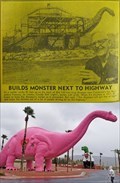 view gallery view galleryN10.3 km |  Cabazon Brontosaurus - Cabazon, CA Cabazon Brontosaurus - Cabazon, CA
in Photos Then and Now The iconic Cabazon brontosaurus known as 'Dinny' is one of two concrete and steel sculptures and are roadside attractions along Interstate 10. posted by: NW_history_buff location: California date approved: 03/04/2021 last visited: 02/01/2016 |
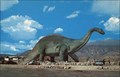 view gallery view galleryN10.3 km |  Cabazon Brontosaurus - Cabazon, CA Cabazon Brontosaurus - Cabazon, CA
in Picture Perfect Postcards The Cabazon Dinosaurs are an iconic roadway attraction along I-10. posted by: NW_history_buff location: California date approved: 03/06/2021 last visited: 02/01/2016 |
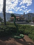 view gallery view galleryN10.3 km |  Snake - Cabazon, CA Snake - Cabazon, CA
in Figurative Public Sculpture A snake sculpture located next to the Cabazon Dinosaurs in Cabazon, California. posted by: bluesnote location: California date approved: 01/17/2023 last visited: 02/01/2016 |
 view gallery view galleryN10.5 km |  Cabazon Dinosaurs - Cabazon, CA Cabazon Dinosaurs - Cabazon, CA
in Weird Story Locations Construction of several life-sized dinosaur sculptures began in 1964. posted by: Metro2 location: California date approved: 06/17/2017 last visited: 01/15/2023 |
|