 view gallery view gallery S10 km S10 km
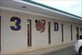
|   3-D Dogs, Maplesville, AL 3-D Dogs, Maplesville, AL
in Classic BBQ and Sandwich Joints A little, off the beaten path shop with excellent sandwiches. posted by:  OHail OHail location: Alabama date approved: 03/15/2012 last visited: 11/01/2012 |
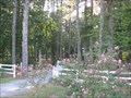
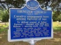 view gallery view galleryS13.8 km |  Ebenezer Church - Stanton, AL Ebenezer Church - Stanton, AL
in Alabama Historical Markers Located within the Ebenezer Baptist Church Cemetery, this marker describes the efforts by the Confederacy to keep the Union military from attacking Selma, which was the second largest arms Confederate manufacturing center. posted by:  hoteltwo hoteltwo location: Alabama date approved: 05/08/2019 last visited: never |
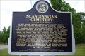 view gallery view gallery E15 km E15 km
| Scandinavian Cemetery in Alabama Historical Markers Marker describing the history of the area and the cemetery posted by: OHail location: Alabama date approved: 05/15/2013 last visited: 04/25/2014 |
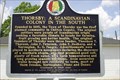 view gallery view gallery NE15.3 km NE15.3 km
| THORSBY: A SCANDINAVIAN COLONY IN THE SOUTH in Alabama Historical Markers Historical marker describing the origins of the Town of Thorsby posted by: OHail location: Alabama date approved: 05/15/2013 last visited: 04/25/2014 |
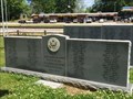 view gallery view galleryNE15.3 km |  Thorsby Remembers Our Veterans - Thorsby, AL Thorsby Remembers Our Veterans - Thorsby, AL
in Non-Specific Veteran Memorials Located in the rural central Alabama city of Thorsby, this memorial honors veterans of this Chilton County area. posted by: hoteltwo location: Alabama date approved: 04/27/2014 last visited: never |
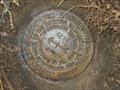
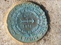
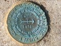
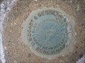
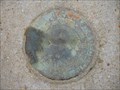 view gallery view galleryE16.3 km |  Peach Azimuth (CN2966) - Clanton, Alabama Peach Azimuth (CN2966) - Clanton, Alabama
in Azimuth Benchmarks The azimuth disk part of the Peach triangulation station disk is located on County Road 76 next to a driveway. It stands out clearly as the concrete extends above ground, and it is next to a witness post. posted by: xptwo location: Alabama date approved: 11/03/2012 last visited: never |
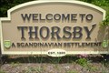 view gallery view galleryE16.3 km |  Welcome to Thorsby, a Scandinavian settlement Welcome to Thorsby, a Scandinavian settlement
in Welcome Signs Sign on the south side of Thorsby welcoming northbound US 31 travelers to the Town of Thorsby posted by: OHail location: Alabama date approved: 05/16/2013 last visited: never |
 view gallery view gallery SE18.5 km SE18.5 km
|  Chilton County Training School - Clanton, AL Chilton County Training School - Clanton, AL
in Former Schools Until the mid-1960s the Chilton County Training School was the only facility in the county that provided a secondary education for black boys and girls. posted by: hummerstation location: Alabama date approved: 03/21/2012 last visited: 10/27/2012 |
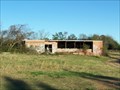 view gallery view gallerySE18.5 km |  Chilton County Training School - Clanton,AL Chilton County Training School - Clanton,AL
in Unoccupied Buildings, Shacks, and Cabins Until the mid-1960s the Chilton County Training School was the only facility in the county that provided a secondary education for African-American children. posted by: hummerstation location: Alabama date approved: 02/20/2013 last visited: 10/27/2012 |
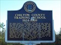 view gallery view gallerySE18.5 km | Chilton County Training School 1924-1969 - Clanton,AL in Alabama Historical Markers Chilton County Training School 1924-1969 Historical Marker - Clanton, AL posted by: hummerstation location: Alabama date approved: 03/11/2012 last visited: 10/27/2012 |
 view gallery view gallery N18.8 km N18.8 km
| MAHAN Azimuth (DH2478) - Brierfield, AL in Azimuth Benchmarks This azimuth is in Bibb County, a few miles from Montevallo, Alabama. posted by: xptwo location: Alabama date approved: 12/09/2012 last visited: never |
 view gallery view galleryE18.8 km |  Clanton Triangulation (CN3233) - Clanton, AL Clanton Triangulation (CN3233) - Clanton, AL
in U.S. Benchmarks This mark is located in front of Trinity Bible Church in Clanton, Alabama. It is easy to spot as the concrete post rises above the ground. posted by: xptwo location: Alabama date approved: 11/24/2012 last visited: never |
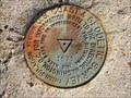
 view gallery view galleryE19.3 km | Clanton Azimuth (CN3238) - Clanton, AL in U.S. Benchmarks This azimuth mark is located on a street corner in a neighborhood in Clanton, Alabama. It can be found at the northeast corner of the intersection of 4th Avenue North and Hannah Street. posted by: xptwo location: Alabama date approved: 10/30/2012 last visited: never |
 view gallery view galleryE19.3 km | Clanton Azimuth (CN3238) - Clanton, AL in Azimuth Benchmarks This azimuth mark is located on a street corner in a neighborhood in Clanton, Alabama. It can be found at the northeast corner of the intersection of 4th Avenue North and Hannah Street. posted by: xptwo location: Alabama date approved: 10/27/2012 last visited: never |
 view gallery view galleryE19.3 km | Clanton West Municipal Tank (CN2964) - Clanton, AL in U.S. Benchmarks The West Municipal Tower is located on the west side of Clanton, Alabama. It is possibly the shortest tower in the area. posted by: xptwo location: Alabama date approved: 11/23/2012 last visited: never |
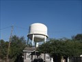 view gallery view galleryE19.3 km |  Clanton West Municipal Tower - Clanton, AL Clanton West Municipal Tower - Clanton, AL
in Water Towers The West Municipal Tank is located on the west side of Clanton, Alabama. It is possibly the shortest tower in the area. posted by: xptwo location: Alabama date approved: 12/23/2012 last visited: never |
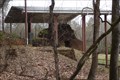
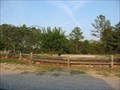 view gallery view galleryNE19.5 km |  Collins Chapel Community Park - Chapel Hill, AL Collins Chapel Community Park - Chapel Hill, AL
in Municipal Parks and Plazas Small park with walking track sitting area and picnic tables posted by: Lazer location: Alabama date approved: 09/21/2007 last visited: 08/27/2009 |
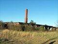
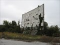 view gallery view galleryE20.1 km |  Clanton Drive-In, Clanton, AL Clanton Drive-In, Clanton, AL
in Closed Drive-In Theatres About all that is left of this drive-in is a deteriorating screen and marquee. posted by: xptwo location: Alabama date approved: 10/28/2012 last visited: never |
 view gallery view galleryN21.6 km |  Brierfield Furnace/Brierfield Ironworks. Brierfield AL Brierfield Furnace/Brierfield Ironworks. Brierfield AL
in Wikipedia Entries Site of the principal iron producer for the Confederate foundry in Selma Alabama posted by: OHail location: Alabama date approved: 01/20/2012 last visited: 12/22/2014 |
 view gallery view galleryN21.6 km |  Bibb Naval Furnaces/Brierfield Furnaces Bibb Naval Furnaces/Brierfield Furnaces
in Iron Furnace Ruins The principal iron producer for the Confederate foundry at Selma where naval guns and ironclads were made. Now part of Brierfield Ironworks Historical State Park. posted by: OHail location: Alabama date approved: 01/27/2012 last visited: 12/22/2014 |
 view gallery view galleryN21.6 km |  Brierfield Furnace - Brierfield, AL Brierfield Furnace - Brierfield, AL
in U.S. National Register of Historic Places Principal iron producer for Confederate foundry at Selma Alabama. Now part of Brierfield Ironworks Historical State Park. posted by: OHail location: Alabama date approved: 01/26/2012 last visited: 12/22/2014 |
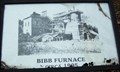 view gallery view galleryN21.6 km |  Bibb Furnace - Brierfield Ironworks Historical State Park, AL Bibb Furnace - Brierfield Ironworks Historical State Park, AL
in Photos Then and Now The Bibb Furnace was also known as the Bibb Naval Furnace and the Brierfield Ironworks. posted by: hummerstation location: Alabama date approved: 12/27/2014 last visited: never |
 view gallery view galleryE21.6 km | Goose Pond Park - Clanton, AL in Municipal Parks and Plazas A large shaded park located in Clanton, AL posted by: Lazer location: Alabama date approved: 09/21/2007 last visited: 10/27/2012 |
 view gallery view galleryE21.7 km | Clanton Bridge (CN1263) - Clanton, AL in U.S. Benchmarks This benchmark is set in one of the concrete supports at a bridge in Clanton, Alabama. posted by: xptwo location: Alabama date approved: 11/23/2012 last visited: never |
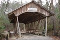 view gallery view galleryN21.7 km |  Overland Road Covered Bridge Overland Road Covered Bridge
in Covered Bridges Covered bridge at Brierfield Ironworks Historical State Park posted by: OHail location: Alabama date approved: 01/20/2012 last visited: never |
|