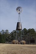
 view gallery view gallery NW0.6 km NW0.6 km
|   Russell Crossroads Windmill Russell Crossroads Windmill
in Windmills Decorative Windmill at the Russell Crossroads posted by:  Blazer3T Blazer3T location: Alabama date approved: 06/17/2021 last visited: never |
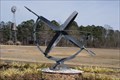 view gallery view galleryNW0.8 km |  Russell Crossroads Sundial, Alexander City, Alabama, U.S.A Russell Crossroads Sundial, Alexander City, Alabama, U.S.A
in Sundials Sundial in the Russell Crossroads Times Square posted by: Blazer3T location: Alabama date approved: 06/14/2021 last visited: never |
 view gallery view galleryNW0.8 km |  Town Clock - Russell Lands, AL Town Clock - Russell Lands, AL
in Town Clocks Town Clocks for Russell Crossroad posted by: Blazer3T location: Alabama date approved: 10/10/2021 last visited: never |
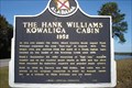 view gallery view gallery SW3.7 km SW3.7 km
|  The Hank Williams Kowaliga Cabin 1952 The Hank Williams Kowaliga Cabin 1952
in Alabama Historical Markers Site where country music legend Hank Williams composed the song “Kaw-liga” in August, 1952. posted by: OHail location: Alabama date approved: 12/14/2011 last visited: 01/20/2021 |
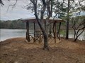 view gallery view gallery SE6.4 km SE6.4 km
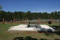
|  The Perch - Dadeville, AL The Perch - Dadeville, AL
in Gazebos Beautiful Wood Gazebo at the end of Old Tree Trail posted by: Blazer3T location: Alabama date approved: 03/24/2020 last visited: never |
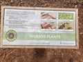 view gallery view gallerySE6.9 km |  Invasive Plants Invasive Plants
in Flora and Fauna Information Signs Information Sign detailing Local Invasive Plants for This Area posted by: Blazer3T location: Alabama date approved: 04/06/2020 last visited: never |
 view gallery view gallerySE6.9 km |  Naive American Heritage - Dadeville, AL USA Naive American Heritage - Dadeville, AL USA
in Signs of History An informational sign about the historical presence of Native Americans in the area. posted by: Blazer3T location: Alabama date approved: 04/04/2020 last visited: never |
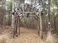 view gallery view gallerySE6.9 km |  Nature's Way Trailhead Arch: Dadeville, AL Nature's Way Trailhead Arch: Dadeville, AL
in Freestanding Arches Arch at the entrance to the Nature's Way Trailhead posted by: Blazer3T location: Alabama date approved: 03/22/2020 last visited: never |
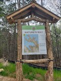 view gallery view gallerySE6.9 km |  Nature's Way Trailhead Nature's Way Trailhead
in Hiking and walking trailheads Trail Head for the Nature's Way set of Trails. posted by: Blazer3T location: Alabama date approved: 04/13/2020 last visited: never |
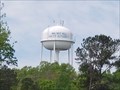 view gallery view gallerySE9 km |  Walnut Hill Water Authority Tower Walnut Hill Water Authority Tower
in Water Towers Local Water Authority Water Tower posted by: Blazer3T location: Alabama date approved: 04/06/2020 last visited: never |
 view gallery view gallery N10.6 km N10.6 km
|  Reunion Trail Wooden Bridge - Wind Creek State Park, AL Reunion Trail Wooden Bridge - Wind Creek State Park, AL
in Eagle Scout Project Sites Wooden bridge built in 2004. posted by: hummerstation location: Alabama date approved: 07/24/2017 last visited: never |
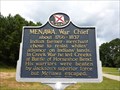 view gallery view galleryN10.9 km | Menawa, War Chief - Alexander City, AL in Alabama Historical Markers Marker located near the entrance to Wind Creek State Park, describes the Indian warrior Menawa. posted by:  hoteltwo hoteltwo location: Alabama date approved: 08/23/2013 last visited: 03/14/2015 |
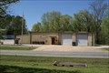 view gallery view gallerySE11.3 km |  Union Volunteer Fire & Rescue Union Volunteer Fire & Rescue
in Firehouses Local Area Volunteer Fire Department posted by: Blazer3T location: Alabama date approved: 04/06/2020 last visited: never |
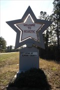 view gallery view gallerySW13.8 km |  Eclectic (Alabama)- Star of Elmore County Eclectic (Alabama)- Star of Elmore County
in Welcome Signs Welcome to Eclectic sign as one is traveling south into town from Lake Martin on AL 63. posted by: OHail location: Alabama date approved: 12/14/2011 last visited: 06/10/2021 |
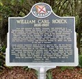 view gallery view gallery E14.5 km E14.5 km
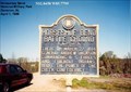
| William Carl Roeck - South of Dadeville, AL in Alabama Historical Markers Located along Stillwaters Hwy (AL-49), this maker describes the life of a notable German immigrant and politician. posted by: hoteltwo location: Alabama date approved: 06/01/2023 last visited: never |
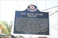 view gallery view galleryE15.4 km | The Rock Store - Dadeville, AL in Alabama Historical Markers Rock Shop in Dadeville, AL built in the 1890's. posted by: Blazer3T location: Alabama date approved: 04/01/2020 last visited: 05/21/2023 |
 view gallery view gallery NE15.8 km NE15.8 km
| Fort Okfuskee (6 mi. west) - Jackson Gap, AL in Alabama Historical Markers Marker placed to identify the location, 6 miles west on US Highway 280, of Fort Oksuskee. posted by: hoteltwo location: Alabama date approved: 08/23/2013 last visited: 07/02/2004 |
 view gallery view gallerySW16.1 km |  Eclectic, Alabama Eclectic, Alabama
in Wikipedia Entries Eclectic, Alabama, with it's smiley face water tower and friendly people is one of my favorite town's in the state. posted by: JacobBarlow location: Alabama date approved: 02/07/2008 last visited: 02/08/2008 |
 view gallery view galleryE16.7 km |  Tallapoosa County Sheriff's Department Tallapoosa County Sheriff's Department
in Police Stations Sheriff's Department for Tallapoosa County, Alabama posted by: Blazer3T location: Alabama date approved: 06/15/2021 last visited: never |
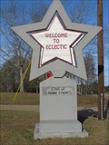 view gallery view gallerySW17.7 km | Star of Elmore County - Eclectic, Alabama in Welcome Signs The Welcome to Eclectic "Star of Elmore County" is one of five such signs. This one is located on Highway 170 and can be seen as one heads north toward the town. posted by: xptwo location: Alabama date approved: 12/17/2011 last visited: never |
 view gallery view gallerySW17.7 km |  Star of Elmore County - Eclectic, Alabama Star of Elmore County - Eclectic, Alabama
in Artistic Welcome Signs The Welcome to Eclectic "Star of Elmore County" sign incorporates their slogan and their history as the place where "stars fell on Alabama." posted by: xptwo location: Alabama date approved: 12/19/2011 last visited: 12/25/2011 |
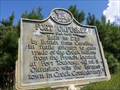
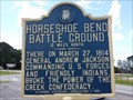 view gallery view galleryNE17.9 km | Horseshoe Bend Battle Ground -12 Miles North in Alabama Historical Markers Marker at the intersection of U.S. Highway 280 and Alabama Route 49 leading to the Horseshoe Bend Battle Ground National Military Park. posted by: hoteltwo location: Alabama date approved: 08/23/2013 last visited: 09/06/2023 |
 view gallery view galleryNE17.9 km | Horseshoe Bend Battle Ground -12 Miles North - Daviston AL in Signs of History Marker at the intersection of U.S. Highway 280 and Alabama Route 49 leading to the Horseshoe Bend Battle Ground National Military Park. posted by: Don.Morfe location: Alabama date approved: 09/06/2023 last visited: 09/06/2023 |
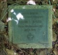
 view gallery view galleryE18 km |  Martha Vivien Banks Speaks Picnic Table - Dadeville, AL Martha Vivien Banks Speaks Picnic Table - Dadeville, AL
in Dedicated Benches Picnic Table dedicated to a local resident. posted by: Blazer3T location: Alabama date approved: 03/31/2020 last visited: never |
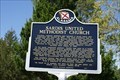 view gallery view galleryE18 km | Sardis United Methodist Church in Alabama Historical Markers Historical marker depiction the history of Sardis United Methodist Church. posted by: Blazer3T location: Alabama date approved: 04/01/2020 last visited: never |
|