 view gallery view gallery N6.3 km N6.3 km
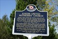
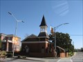
|   Sardis United Methodist Church Sardis United Methodist Church
in Alabama Historical Markers Historical marker depiction the history of Sardis United Methodist Church. posted by:  Blazer3T Blazer3T location: Alabama date approved: 04/01/2020 last visited: never |
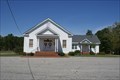 view gallery view galleryN6.3 km |  Sardis United Methodist Church - Dadeville, AL Sardis United Methodist Church - Dadeville, AL
in Methodist Churches Sardis Baptist Church in Dadeville Est. 1837 posted by: Blazer3T location: Alabama date approved: 03/27/2020 last visited: never |
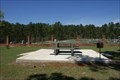 view gallery view galleryN6.3 km |  Martha Vivien Banks Speaks Picnic Table - Dadeville, AL Martha Vivien Banks Speaks Picnic Table - Dadeville, AL
in Dedicated Benches Picnic Table dedicated to a local resident. posted by: Blazer3T location: Alabama date approved: 03/31/2020 last visited: never |
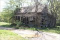
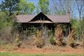 view gallery view gallery NE6.9 km NE6.9 km
|  Abandoned Home - Dadeville, AL - United States Abandoned Home - Dadeville, AL - United States
in Unoccupied Buildings, Shacks, and Cabins Located on Girls Ranch Road in Dadeville. posted by: Blazer3T location: Alabama date approved: 03/27/2020 last visited: never |
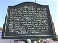 view gallery view gallery SW7.1 km SW7.1 km
| Site of Thaddeus Post Office - Notasulga, AL in Alabama Historical Markers Marker in current community of Reeltown, Alabama about the establishment of a Post Office in the then town of Thaddeus. posted by:  hoteltwo hoteltwo location: Alabama date approved: 08/23/2013 last visited: 02/03/2021 |
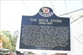 view gallery view gallery NW7.7 km NW7.7 km
| The Rock Store - Dadeville, AL in Alabama Historical Markers Rock Shop in Dadeville, AL built in the 1890's. posted by: Blazer3T location: Alabama date approved: 04/01/2020 last visited: 05/21/2023 |
 view gallery view galleryNE9.8 km | Abandoned Home - Roxana, AL - United States in Unoccupied Buildings, Shacks, and Cabins Abandoned home in Roxana, AL near Auburn, AL. posted by: Blazer3T location: Alabama date approved: 03/27/2020 last visited: never |
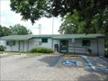
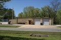 view gallery view galleryNW10.6 km |  Union Volunteer Fire & Rescue Union Volunteer Fire & Rescue
in Firehouses Local Area Volunteer Fire Department posted by: Blazer3T location: Alabama date approved: 04/06/2020 last visited: never |
 view gallery view gallery SE12.1 km SE12.1 km
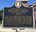
| Birthplace of Zora Neale Hurston - Notasulga, AL in Alabama Historical Markers Located on Auburn Road, 0.3 miles east of Tallapoosa Street, describes the noted authors' local beginnings and a history of her writings. posted by: hoteltwo location: Alabama date approved: 06/25/2016 last visited: 07/11/2022 |
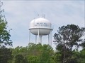 view gallery view galleryNW13 km |  Walnut Hill Water Authority Tower Walnut Hill Water Authority Tower
in Water Towers Local Water Authority Water Tower posted by: Blazer3T location: Alabama date approved: 04/06/2020 last visited: never |
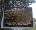 view gallery view gallerySE14.2 km | Camp Watts Named for Thomas H. Watts in Alabama Historical Markers Located along Union Camp Rd., south of Notasulga, this marker notes the former area of a Civil War camp and cemetery. Camp Watts is currently private property and is used for cattle. posted by: hoteltwo location: Alabama date approved: 06/21/2016 last visited: 07/11/2022 |
 view gallery view gallery E14.3 km E14.3 km
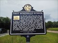
| First Rosenwald School - Loachapoka, AL in Alabama Historical Markers This two-sided marker in Loachapoka, Alabama, tells the history of the first of 5,300 Rosenwald schools for black children to be built. posted by: xptwo location: Alabama date approved: 08/01/2013 last visited: 01/12/2022 |
 view gallery view galleryE14.3 km |  Auburn University Chapel - Auburn, AL Auburn University Chapel - Auburn, AL
in Wikipedia Entries The Auburn University Chapel has had many uses since it was built in 1850 as a Presbyterian Church, including time as a YMCA center and theater. posted by: xptwo location: Alabama date approved: 03/24/2013 last visited: never |
 view gallery view galleryE14.8 km |  Loachapoka, Alabama 36865 Loachapoka, Alabama 36865
in U.S. Post Offices This post office is located at 6520 Stage Road in Loachapoka, Alabama. Stage Road is also known as Alabama Highway 14. posted by: xptwo location: Alabama date approved: 07/29/2013 last visited: never |
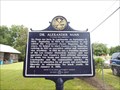 view gallery view galleryE14.8 km | Dr. Alexander Nunn - Loachapoka, AL in Alabama Historical Markers This particular marker in Pioneer Park in Loachapoka, Alabama, honors the memory of Dr. Alexander Nunn, the first historian for Lee County. posted by: xptwo location: Alabama date approved: 08/24/2013 last visited: 01/12/2022 |
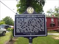 view gallery view galleryE14.8 km | Lee County Historical Society - Loachapoka, AL in Alabama Historical Markers This marker gives the history of those who founded the Lee County Historical Society. It is located in Pioneer Park in Loachapoka, Alabama. posted by: xptwo location: Alabama date approved: 08/01/2013 last visited: 01/12/2022 |
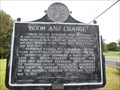 view gallery view galleryE14.8 km | Boom and Change - Loachapoka, AL in Alabama Historical Markers Placed by the Historic Chattahoochee Commission in 1978, this marker tells of the rise and fall of the town of Loachapoka, Alabama. posted by: xptwo location: Alabama date approved: 08/23/2013 last visited: 03/08/2006 |
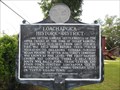 view gallery view galleryE14.8 km | Loachapoka Historic District - Loachapoka, AL in Alabama Historical Markers This historic marker relates the early history of the town of Loachapoka, Alabama. It is located in Pioneer Park. posted by: xptwo location: Alabama date approved: 07/29/2013 last visited: 03/08/2006 |
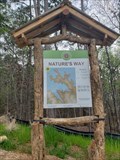 view gallery view galleryNW15 km |  Nature's Way Trailhead Nature's Way Trailhead
in Hiking and walking trailheads Trail Head for the Nature's Way set of Trails. posted by: Blazer3T location: Alabama date approved: 04/13/2020 last visited: never |
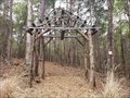 view gallery view galleryNW15 km |  Nature's Way Trailhead Arch: Dadeville, AL Nature's Way Trailhead Arch: Dadeville, AL
in Freestanding Arches Arch at the entrance to the Nature's Way Trailhead posted by: Blazer3T location: Alabama date approved: 03/22/2020 last visited: never |
 view gallery view galleryNW15 km |  Naive American Heritage - Dadeville, AL USA Naive American Heritage - Dadeville, AL USA
in Signs of History An informational sign about the historical presence of Native Americans in the area. posted by: Blazer3T location: Alabama date approved: 04/04/2020 last visited: never |
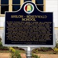 view gallery view gallerySE15 km | Shiloh-Rosenwald School - Notasulga, Alabama in Alabama Historical Markers Marker is at the intersection of Tuskegee Street (AL-81) and Shiloh Road south of Notasulga describes one of the early (and few remaining) African-American school houses funded by Sears founder Julius Rosenwald. posted by: hoteltwo location: Alabama date approved: 06/21/2016 last visited: 07/11/2022 |
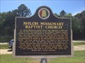 view gallery view gallerySE15 km | Shiloh Missionary Baptist Church - Notasulga, AL in Alabama Historical Markers Located at the intersection of Tuskegee Street (AL-81) and Shiloh Road, south of Notasulga, describes the church and largest site of the infamous Tuskegee syphilis study. posted by: hoteltwo location: Alabama date approved: 06/25/2016 last visited: 07/11/2022 |
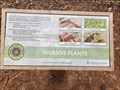 view gallery view galleryNW15 km |  Invasive Plants Invasive Plants
in Flora and Fauna Information Signs Information Sign detailing Local Invasive Plants for This Area posted by: Blazer3T location: Alabama date approved: 04/06/2020 last visited: never |
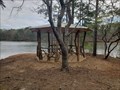 view gallery view galleryNW15.4 km |  The Perch - Dadeville, AL The Perch - Dadeville, AL
in Gazebos Beautiful Wood Gazebo at the end of Old Tree Trail posted by: Blazer3T location: Alabama date approved: 03/24/2020 last visited: never |
|