 view gallery view gallery SE15.1 km SE15.1 km
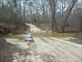
|   Autauga County 78 Crossing - Autaugaville, AL Autauga County 78 Crossing - Autaugaville, AL
in Bridgeless Water Crossings This crossing is located on Autauga County 78, west of Autaugaville, Alabama. posted by:  xptwo xptwo location: Alabama date approved: 03/06/2013 last visited: never |
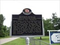
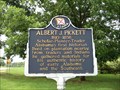 view gallery view gallerySE18.3 km |  Albert J. Pickett - Autaugaville, Alabama Albert J. Pickett - Autaugaville, Alabama
in Alabama Historical Markers Alabama's first historian is celebrated in this marker located west of Autaugaville, Alabama, along Alabama Highway 14. posted by: xptwo location: Alabama date approved: 06/18/2012 last visited: 09/26/2013 |
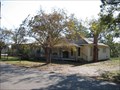 view gallery view gallerySE19.8 km |  Autaugaville Public Library - Autaugaville, Alabama Autaugaville Public Library - Autaugaville, Alabama
in Libraries The Autaugaville Public Library is a branch of the Autauga Prattville Public Libraries system. posted by: xptwo location: Alabama date approved: 11/07/2011 last visited: never |
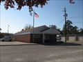 view gallery view gallerySE20 km |  Autaugaville, AL - 36003 Autaugaville, AL - 36003
in U.S. Post Offices The Autaugaville post office is located at 105 North Taylor Street, near the intersection with Alabama Highway 14. posted by: xptwo location: Alabama date approved: 11/09/2011 last visited: never |
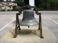 view gallery view gallerySE20.1 km |  Autaugaville Baptist Church Bell - Autaugaville, AL Autaugaville Baptist Church Bell - Autaugaville, AL
in Bells This bell is on display in the parking lot of Autaugaville Baptist Church. posted by: xptwo location: Alabama date approved: 11/13/2012 last visited: never |
 view gallery view gallerySE20.3 km | Autaugaville - Autaugaville, Alabama in Alabama Historical Markers Marker noting the 1935 Autaugaville, Alabama, mention in Ripley's Believe It Or Not! column. posted by: xptwo location: Alabama date approved: 06/11/2012 last visited: 09/26/2013 |
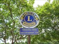 view gallery view gallerySE21.6 km |  Lions Club - Autaugaville, AL Lions Club - Autaugaville, AL
in Lions Clubs International Markers This Lions Club logo next to the Welcome to Autaugaville sign tells the location and times when the local club meets. posted by: xptwo location: Alabama date approved: 06/05/2013 last visited: never |
 view gallery view gallerySE21.6 km |  Autaugaville, Alabama - Population 1,099 Autaugaville, Alabama - Population 1,099
in Population Signs The town of Autaugaville is located in Autauga County, Alabama, on Alabama Highway 14. The posted coordinates are for the welcome sign on the east side of town. posted by: xptwo location: Alabama date approved: 12/20/2011 last visited: never |
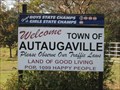
 view gallery view gallerySE21.6 km |  "Land of Good Living" - Autaugaville, Alabama "Land of Good Living" - Autaugaville, Alabama
in Welcome Signs The town of Autaugaville is located in Autauga County, Alabama, on Alabama Highway 14. The posted coordinates are for the welcome sign on the east side of town. posted by: xptwo location: Alabama date approved: 11/06/2011 last visited: never |
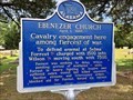 view gallery view gallery NW21.9 km NW21.9 km
| Ebenezer Church - Stanton, AL in Alabama Historical Markers Located within the Ebenezer Baptist Church Cemetery, this marker describes the efforts by the Confederacy to keep the Union military from attacking Selma, which was the second largest arms Confederate manufacturing center. posted by:  hoteltwo hoteltwo location: Alabama date approved: 05/08/2019 last visited: never |
 view gallery view gallery SW22.4 km SW22.4 km
|  Valley Creek Cemetery -- Valley Grande, AL Valley Creek Cemetery -- Valley Grande, AL
in Worldwide Cemeteries Peaceful Valley Creek Cemetery in the rural community of Valley Grande, northwest of Selma AL posted by: Benchmark Blasterz location: Alabama date approved: 03/08/2019 last visited: 01/14/2019 |
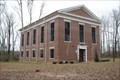 view gallery view gallerySW22.5 km |  Valley Creek Presbyterian Church -- Valley Grande AL Valley Creek Presbyterian Church -- Valley Grande AL
in Presbyterian Churches A simple unadorned church building built with slave made bricks and slave labor stands in the rural community of Valley Grande, northwest of Selma posted by: Benchmark Blasterz location: Alabama date approved: 03/06/2019 last visited: 01/14/2019 |
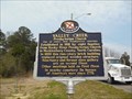 view gallery view gallerySW22.9 km | Valley Creek Presbyterian Church - Selma, AL in Alabama Historical Markers The marker is located on Citizens Parkway (Alabama Hwy 22), at the intersection with County Road 65, north of Selma, Alabama. It tells the history of Valley Creek Presbyterian Church. posted by: xptwo location: Alabama date approved: 06/01/2013 last visited: 01/14/2019 |
 view gallery view gallerySW23.3 km | British West Florida - Selma, AL in Alabama Historical Markers This marker notes the north boundary line for the British colony of West Florida during its existence from 1764 to 1783. posted by: xptwo location: Alabama date approved: 04/15/2013 last visited: never |
 view gallery view gallerySW23.3 km |  British West Florida - Selma, Alabama British West Florida - Selma, Alabama
in UK Historical Markers This marker notes the north boundary line for the British colony of West Florida during its existence from 1764 to 1783. posted by: xptwo location: Alabama date approved: 03/11/2013 last visited: never |
 view gallery view gallery W24.3 km W24.3 km
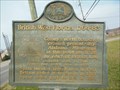
| Childers Chapel - Valley Grande, AL in Alabama Historical Markers Historic rural cemetery along County Road 37, north of Selma, includes many older grave markers. Access is difficult as the gates have chains and locks. posted by: hoteltwo location: Alabama date approved: 02/17/2015 last visited: never |
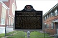
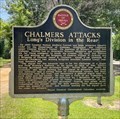 view gallery view gallerySW24.3 km | Chalmers Attacks - Valley Grande, AL in Alabama Historical Markers Located near Keenan's Mill on Lapsley Street the marker describes Union Gen. Wilson's advance into Alabama to destroy the arms depots in Selma near the end of the Civil War. posted by: hoteltwo location: Alabama date approved: 05/31/2023 last visited: never |
 view gallery view gallery N24.5 km N24.5 km
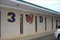
|  3-D Dogs, Maplesville, AL 3-D Dogs, Maplesville, AL
in Classic BBQ and Sandwich Joints A little, off the beaten path shop with excellent sandwiches. posted by: OHail location: Alabama date approved: 03/15/2012 last visited: 11/01/2012 |
 view gallery view gallery E24.6 km E24.6 km
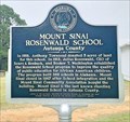
| Mount Sinai Rosenwald School - near Prattville, AL in Alabama Historical Markers First public school for African-American students in Autauga County. One of the many Rosenwald schools that was partially paid for the CEO of Sears Roebuck in 1919. posted by: hoteltwo location: Alabama date approved: 11/23/2020 last visited: never |
 view gallery view gallerySW24.6 km |  Lannie's Bar-B-Q Spot -- Selma AL Lannie's Bar-B-Q Spot -- Selma AL
in Historic Eats Lannie's Bar-B-Q Spot has been serving up outstanding BBQ since 1946 posted by: Benchmark Blasterz location: Alabama date approved: 03/06/2019 last visited: 01/14/2019 |
 view gallery view gallerySW24.6 km | Lannie's Bar-B-Q Spot -- Selma AL in Classic BBQ and Sandwich Joints We had the best barbecue we've ever had in Alabama at this very humble neighborhood barbecue joint in an economically disadvantaged neighborhood in Selma. posted by: Benchmark Blasterz location: Alabama date approved: 03/07/2019 last visited: 01/15/2019 |
 view gallery view gallerySW25.4 km | George Washington Carver Homes Projects -- Selma AL in Alabama Historical Markers A state historic marker for the George Washington Carver Homes Projects, a bleak post-WWII housing project development for impoverished blacks in segregated Selma AL posted by: Benchmark Blasterz location: Alabama date approved: 09/07/2017 last visited: 07/01/2023 |
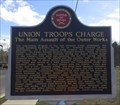 view gallery view gallerySW25.4 km | Union Troops Charge - Selma, AL in Alabama Historical Markers Notes the major actions at nearby fortifications in Selma during the Battle of Selma at the end of the Civil War. Marker is at the intersection of Summerfield Road and Highland Avenue. posted by: hoteltwo location: Alabama date approved: 04/07/2015 last visited: 04/30/2018 |
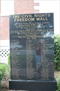 view gallery view gallerySW25.4 km |  Civil Rights Freedom Wall -- Selma AL Civil Rights Freedom Wall -- Selma AL
in Civil Rights Memorials A polished black granite memorial known as the Civil Rights Freedom Wall at the Brown Chapel AME church in Selma AL posted by: Benchmark Blasterz location: Alabama date approved: 09/01/2017 last visited: 07/01/2023 |
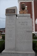 view gallery view gallerySW25.4 km | MLK Monument -- Brown Chapel AME Church, Selma AL in Civil Rights Memorials This modern grey granite memorial in front of the Brown Chapel AME Church in the George Washington Carver Homes area of Selma posted by: Benchmark Blasterz location: Alabama date approved: 09/01/2017 last visited: 07/01/2023 |
|