 view gallery view gallery SE11.1 km SE11.1 km
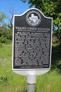
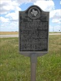
|   Valley Creek Station Valley Creek Station
in Texas Historical Markers Texas Historical Marker noting the activity of the Butterfield Overland Mail Route in this area, as well as the communities that it spawned. This marker is on the north side of FM 1086, just slightly west of US 277 in southwestern Taylor County. posted by:  QuarrellaDeVil QuarrellaDeVil location: Texas date approved: 04/27/2017 last visited: never |
 view gallery view gallery S16.7 km S16.7 km
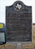
| Fort Chadbourne in Texas Historical Markers Fort Chadbourne - Texas Historical Marker. This is part of our HWY 277 Waymark series. posted by:  the4defaus the4defaus location: Texas date approved: 01/26/2007 last visited: 12/12/2015 |
 view gallery view gallerySE19.3 km |  Wingate Baptist Church Bell Wingate Baptist Church Bell
in Bells Located at 301 County Rd 395, Wingate TX. posted by: GeoGrands location: Texas date approved: 07/06/2008 last visited: 07/04/2008 |
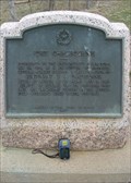
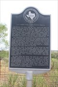
 view gallery view galleryS20.8 km | Southern Overland Mail, 1858-1861 in Texas Historical Markers Route of the Southern Overland Mail Line - Texas Historical Marker. This is part of our HWY 277 Waymark series. posted by: the4defaus location: Texas date approved: 01/26/2007 last visited: never |
 view gallery view gallery E21.7 km E21.7 km
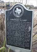
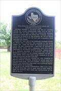
| In Vicinity of Coronado's Camp in Texas Historical Markers Coronado's Camp Texas Historical Marker. This is part of our HWY 277 Waymark series. posted by: the4defaus location: Texas date approved: 01/26/2007 last visited: 04/06/2010 |
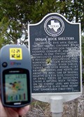 view gallery view galleryS22 km | Indian Rock Shelters in Texas Historical Markers Indian Rock Shelters - Texas Historical Marker. This is part of our HWY 277 Waymark series. posted by: the4defaus location: Texas date approved: 01/26/2007 last visited: 03/14/2010 |
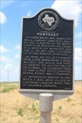 view gallery view gallerySE23.3 km | Community of Pumphrey in Texas Historical Markers Texas Historical Marker at the corner of FM 1677 and CR 309 in Pumphrey, TX, which has settled down today as a quiet rural settlement. It provides a little bit of history. posted by: QuarrellaDeVil location: Texas date approved: 08/09/2019 last visited: never |
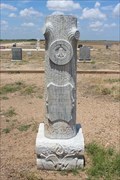
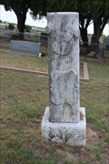
 view gallery view gallerySE24 km |  James G. Aten - Pumphrey New Hope Cemetery - Pumphrey, TX James G. Aten - Pumphrey New Hope Cemetery - Pumphrey, TX
in Woodmen of the World Grave Markers/Monuments Woodmen of the World monument for James G. Aten in Pumphrey New Hope Cemetery, Pumphrey, TX. posted by: QuarrellaDeVil location: Texas date approved: 06/27/2020 last visited: never |
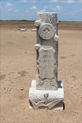
 view gallery view gallerySE24.1 km | Joe L. Hamilton - Pumphrey New Hope Cemetery - Pumphrey, TX in Woodmen of the World Grave Markers/Monuments Woodmen of the World monument for Joe Leamon Hamilton in Pumphrey New Hope Cemetery, Pumphrey, TX. Thanks to Findagrave for information about his name. posted by: QuarrellaDeVil location: Texas date approved: 06/26/2020 last visited: never |
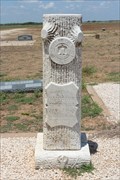
 view gallery view gallerySE24.1 km | G. Mayson Dennis - Pumphrey New Hope Cemetery - Pumphrey, TX in Woodmen of the World Grave Markers/Monuments Woodmen of the World monument for G. Mayson Dennis in Pumphrey New Hope Cemetery, Pumphrey, TX. posted by: QuarrellaDeVil location: Texas date approved: 06/26/2020 last visited: never |
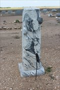 view gallery view gallerySE24.1 km | Connie Russell Byers - Pumphrey New Hope Cemetery - Pumphrey, TX in Woodmen of the World Grave Markers/Monuments Woodmen of the World monument for Connie Russell Byers in Pumphrey New Hope Cemetery, Pumphrey, TX. posted by: QuarrellaDeVil location: Texas date approved: 06/26/2020 last visited: never |
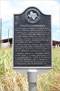 view gallery view gallerySE24.3 km | Drasco Community in Texas Historical Markers Texas Historical Marker noting this as the general area of the Drasco community, which seems to have started small and remained that way. It faces FM 2595 on the northeast side of its intersection with FM 2405. posted by: QuarrellaDeVil location: Texas date approved: 06/27/2020 last visited: never |
 view gallery view galleryS25.4 km | Site of Old Communities of Mazeland and Wilmeth in Texas Historical Markers Texas Historical Marker on FM 383 in Wilmeth, TX in front of the Wingate Masonic Lodge, providing some background on both Wilmeth and nearby Mazeland, two communities that were essentially joined at the hip. posted by: QuarrellaDeVil location: Texas date approved: 08/14/2019 last visited: never |
 view gallery view galleryS26.1 km | Viola Ensor Clark - Wilmeth Cemetery - Wilmeth, TX in Woodmen of the World Grave Markers/Monuments Woodmen Circle monument for Viola (Ensor) Clark, in Wilmeth Cemetery, Wilmeth, TX. posted by: QuarrellaDeVil location: Texas date approved: 08/14/2019 last visited: never |
 view gallery view gallery NE26.9 km NE26.9 km
|  FIRST American Female Pilot to Die on Active Miltary Duty - Merkel, TX FIRST American Female Pilot to Die on Active Miltary Duty - Merkel, TX
in First of its Kind A 2000 Texas Historical Marker notes that Cornelia Clark Fort was the first American woman pilot to die on active military duty when she was killed in an accident on March 21, 1943. posted by: QuarrellaDeVil location: Texas date approved: 08/27/2017 last visited: never |
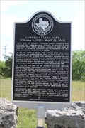 view gallery view galleryNE26.9 km | Cornelia Clark Fort in Texas Historical Markers Texas Historical Marker in a roadside pullout at the intersection of FM 126 and FM 1085, southwest of Merkel, TX, noting the all-too-brief career of Cornelia Clark Fort, who was in the air when Pearl Harbor began. posted by: QuarrellaDeVil location: Texas date approved: 09/06/2017 last visited: 12/29/2017 |
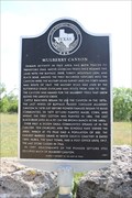 view gallery view galleryNE26.9 km | Mulberry Canyon in Texas Historical Markers Texas Historical Marker in a roadside pullout at the intersection of FM 126 and FM 1085, southwest of Merkel, TX, noting settlement in nearby Mulberry Canyon. posted by: QuarrellaDeVil location: Texas date approved: 09/07/2017 last visited: never |
 view gallery view gallery N28.8 km N28.8 km
|  Lake Sweetwater Recreation Area – Sweetwater TX Lake Sweetwater Recreation Area – Sweetwater TX
in Civilian Conservation Corps Amphitheater and other park improvements. posted by: WalksfarTX location: Texas date approved: 04/16/2019 last visited: never |
 view gallery view gallerySE29.5 km | Poe Chapel in Texas Historical Markers Location is: from Winters, take SH 153 west about 6 miles to JCT of SH 153, FM 384 and FM 2111. posted by: GeoGrands location: Texas date approved: 07/08/2008 last visited: 07/04/2008 |
 view gallery view gallery NW30.1 km NW30.1 km
|  U.S. Army Air Corps Plane Crash - Sweetwater, TX U.S. Army Air Corps Plane Crash - Sweetwater, TX
in Disaster Memorials A 2000 Texas Historical Marker in a roadside pullout on the east side of TX 70, about 2.4 miles south of Sweetwater, provides a narrative of the plane crash that killed twenty-five US servicemen east of here in 1945. posted by: QuarrellaDeVil location: Texas date approved: 09/08/2021 last visited: never |
 view gallery view galleryNW30.1 km | Site of U. S. Army Air Corps Plane Crash in Texas Historical Markers Texas Historical Marker about 2.4 miles south of I-20, south of Sweetwater, providing some background as to the fatal crash of a C-47 that occurred near here in 1945, killing twenty-five. posted by: QuarrellaDeVil location: Texas date approved: 09/08/2021 last visited: never |
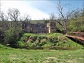
 view gallery view galleryE31.1 km | The Civilian Conservation Corps at Abilene State Park in Texas Historical Markers Texas Historical Marker across from the CCC-constructed swimming pool bathhouse in Abilene State Park, providing some background on the work of the Civilian Conservation Corps here in this wonderful park. posted by: QuarrellaDeVil location: Texas date approved: 09/06/2019 last visited: never |
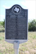 view gallery view galleryNE31.7 km | Castle Peak in Texas Historical Markers Texas Historical Marker noting the passage of the Butterland Overland Mail Route through the area, and the use of Abercrombie Peak -- now Castle Peak -- as a beacon. posted by: QuarrellaDeVil location: Texas date approved: 05/02/2017 last visited: never |
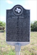 view gallery view galleryNE31.7 km | Vicinity of Indian Fight in Texas Historical Markers Texas Historical Marker noting an 1871 battle between Native American horse rustlers and the posse who went after them. posted by: QuarrellaDeVil location: Texas date approved: 05/02/2017 last visited: 02/01/2022 |
 view gallery view gallery SW31.9 km SW31.9 km
| Hayrick in Texas Historical Markers 1936 Centennial - Subject Marker (gray granite) posted by: WalksfarTX location: Texas date approved: 02/05/2018 last visited: never |
|