 view gallery view gallery NE7.4 km NE7.4 km
|   Old Federal Road - Shackleville, AL Old Federal Road - Shackleville, AL
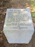
in Alabama Historical Markers One of eight stone markers along the Alabama portion of the Federal road established as a postal route by President Jefferson. Located on County Road 38 just west of County Road 7. posted by:  hoteltwo hoteltwo location: Alabama date approved: 07/22/2015 last visited: never |
 view gallery view gallery W9.5 km W9.5 km
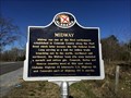
| Midway - Midway, AL in Alabama Historical Markers Marker notes the community started here and is located at the intersection of State, County and U.S. highways. It should not to be confused with the incorporated town of Midway that’s located in Bullock County. posted by: hoteltwo location: Alabama date approved: 03/12/2015 last visited: never |
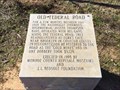 view gallery view galleryW10 km | Old Federal Road - Midway Alabama in Alabama Historical Markers One of eight stone markers along the Alabama portion of the Federal road established as a postal route by President Jefferson. Located at the intersection of County Road 1 and State Route 83 in Conecuh County. posted by: hoteltwo location: Alabama date approved: 03/24/2015 last visited: never |
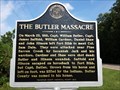 view gallery view galleryNE17.1 km | The Butler Massacre - Forest Home, AL in Alabama Historical Markers Replacement marker describing the history of the naming of Butler County and its namesake. posted by: hoteltwo location: Alabama date approved: 08/28/2013 last visited: 06/15/2019 |
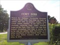 view gallery view galleryNE17.1 km | Fort Bibb - Forest Home, AL in Alabama Historical Markers Replacement marker describing the construction and use of Fort Bibb. posted by: hoteltwo location: Alabama date approved: 08/28/2013 last visited: never |
 view gallery view gallery N18.5 km N18.5 km
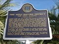
| Pine Apple, Alabama Historic District in Alabama Historical Markers Marker describes the history and economics of this small town with an historic district. The town hosts annual "Hunter Appreciation Day" each November and a semi-annual Front Porch Tour. posted by: hoteltwo location: Alabama date approved: 08/28/2013 last visited: never |
 view gallery view galleryW18.7 km | Old Federal Road - Pine Orchard, AL in Alabama Historical Markers One of eight stone markers along the Alabama portion of the Federal road established as a postal route by President Jefferson. Located on County Road 5, south of County Road 42. posted by: hoteltwo location: Alabama date approved: 03/24/2015 last visited: never |
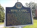 view gallery view galleryN19.3 km | Moore Academy - Pine Apple, AL in Alabama Historical Markers This former school is one of the 73 properties included in the Pine Apple Historic District that’s listed on the National Register of Historic Places. posted by: hoteltwo location: Alabama date approved: 08/28/2013 last visited: never |
 view gallery view galleryN20 km |  Pine Apple, Alabama Pine Apple, Alabama
in City and Town Halls A small town hall for a small town with many historic sites. The name of the town may have come from the areas pine and apple trees. posted by: hoteltwo location: Alabama date approved: 08/29/2013 last visited: never |
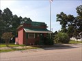
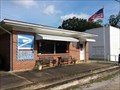 view gallery view galleryN20 km |  Pine Apple, Alabama 36768 Pine Apple, Alabama 36768
in U.S. Post Offices Small town post office located in the Pine Apple Historic District of which several historic buildings are listed in the National Register of Historic Places. posted by: hoteltwo location: Alabama date approved: 08/28/2013 last visited: never |
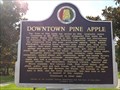 view gallery view galleryN20 km | Downtown Pine Apple, Alabama in Alabama Historical Markers Marker describing the founding and history of Pine Apple. It includes a listing of the early settlers. posted by: hoteltwo location: Alabama date approved: 08/28/2013 last visited: never |
 view gallery view gallery E20.9 km E20.9 km
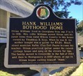
| Hank Williams' Boyhood Home - Georgiana, AL in Alabama Historical Markers Located on Rose Street, this marker is in front of the old boyhood home of country music legend Hank Williams, Sr. The home today is a museum. posted by: hoteltwo location: Alabama date approved: 03/12/2015 last visited: never |
 view gallery view galleryE20.9 km | Thigpen’s Log Cabin Popular Dance Hall - Georgiana, AL in Alabama Historical Markers The log cabin is located behind the Hank Williams Boyhood Home and Museum on Rose Street and is often used for festivals. posted by: hoteltwo location: Alabama date approved: 03/12/2015 last visited: never |
 view gallery view gallery SW21.9 km SW21.9 km
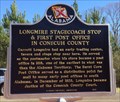
| Longmire Stagecoach Stop - Burnt Corn, AL in Alabama Historical Markers Marker located along the rural County Road 5, north of Burnt Corn. Notes the early history of Conecuh County postal service. posted by: hoteltwo location: Alabama date approved: 03/22/2015 last visited: never |
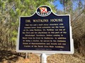 view gallery view gallerySW23.8 km | Dr. Watkins House - Burnt Corn, AL in Alabama Historical Markers Located on Conecuh County Rd 5, about a mile north of CR-15, notes the house and life of a prominent doctor and politician, John Watkins. posted by: hoteltwo location: Alabama date approved: 03/22/2015 last visited: never |
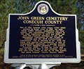 view gallery view gallerySW24.6 km | John Green Cemetery - Burnt Corn, AL in Alabama Historical Markers Located near the community of Burnt Corn, this cemetery contains Civil War and war of 1812 graves. The cemetery is well off the main road and you will need some GPS sense to find it. The cemetery is now well taken care of. posted by: hoteltwo location: Alabama date approved: 03/12/2015 last visited: never |
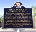 view gallery view gallerySW24.9 km | First School in Conecuh County - Burnt Corn, AL in Alabama Historical Markers Located on Conecuh County Road 15, east of County Road 5 this marker notes the former location of the first school in this rural county. posted by: hoteltwo location: Alabama date approved: 03/22/2015 last visited: never |
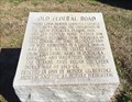 view gallery view gallerySW25.4 km | Old Federal Road - Burnt Corn, AL in Alabama Historical Markers One of eight stone markers along the Alabama portion of the Federal road established as a postal route by President Jefferson. Located at the intersection of County Road 5 and County Road 15. posted by: hoteltwo location: Alabama date approved: 03/24/2015 last visited: never |
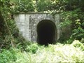 view gallery view galleryW26.1 km |  Tunnel Springs, AL Abandoned Train Tunnel Tunnel Springs, AL Abandoned Train Tunnel
in Abandoned Train Tunnels Abandoned Train Tunnel located near the town of Tunnel Springs, Alabama. posted by:  Six Little Spookies Six Little Spookies location: Alabama date approved: 12/30/2007 last visited: 04/12/2014 |
 view gallery view gallery NW27.8 km NW27.8 km
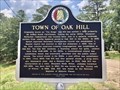
| Town of Oak Hill - Oak Hill, AL in Alabama Historical Markers Marker located at intersection of AL-21 and Dale Drive, provides the settlement history of the town and its churches, schools and commercial beginnings. posted by: hoteltwo location: Alabama date approved: 08/06/2020 last visited: never |
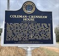 view gallery view galleryNE28.5 km | Coleman-Crenshaw House - Greenville, AL in Alabama Historical Markers Marker located near the Mt. Olive Missionary Baptist Church, on Ridge Road at Crenshaw Road, describes one of the counties pioneer families and home. posted by: hoteltwo location: Alabama date approved: 02/17/2019 last visited: never |
 view gallery view gallery S29.1 km S29.1 km
| Evergreen, AL 36401 in U.S. Post Offices This fine old Post Office serves Evergreen, Alabama. posted by: The Snowdog location: Alabama date approved: 01/28/2023 last visited: never |
 view gallery view galleryS29.1 km |  Evergreen Courant - Evergreen, AL Evergreen Courant - Evergreen, AL
in Newspaper Headquarters The Evergreen Courant has been providing the news since 1895 - in Evergreen, Alabama. posted by: The Snowdog location: Alabama date approved: 01/28/2023 last visited: never |
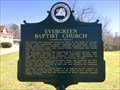 view gallery view galleryS29.1 km | Evergreen Baptist Church - Evergreen, AL in Alabama Historical Markers Marker located on Park St notes the beginnings of the Evergreen Baptist Church and lists the pastors and lists the pastorates as well. posted by: hoteltwo location: Alabama date approved: 03/12/2015 last visited: never |
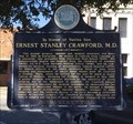 view gallery view galleryS29.3 km | Ernest Stanley Crawford, M.D. - Evergreen, AL in Alabama Historical Markers Located along the railroad tracks in the historic district, this marker notes the life of a renowned vascular surgeon born in this city. posted by: hoteltwo location: Alabama date approved: 03/12/2015 last visited: never |
|