 view gallery view gallery N0 km N0 km
|   James Campbell - Sardis Cemetery - Greenville, AL James Campbell - Sardis Cemetery - Greenville, AL
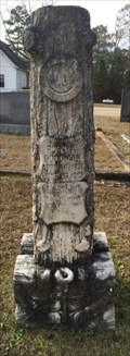
in Woodmen of the World Grave Markers/Monuments WOW monument for James Franklin Campbell born Feb. 2, 1874 and died Oct. 19, 1919. posted by:  hoteltwo hoteltwo location: Alabama date approved: 12/14/2013 last visited: never |
 view gallery view gallery NE0 km NE0 km
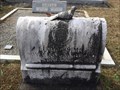
| Lucy L. Sims - Sardis Cemetery - Greenville, AL in Woodmen of the World Grave Markers/Monuments Lucy Sims was a Member of the Supreme Forest Woodmen Circle and was born Nov. 2, 1883 and died Jan. 28, 1930 living in Pigeon Creek, AL. posted by: hoteltwo location: Alabama date approved: 12/14/2013 last visited: never |
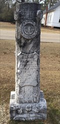
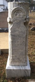 view gallery view galleryN0.2 km | James Curington - Sardis Cemetery, Greenville, AL in Woodmen of the World Grave Markers/Monuments WOW tombstone for James Curington born Mar. 18, 1873 and died Jul. 20, 1926. posted by: hoteltwo location: Alabama date approved: 12/14/2013 last visited: never |
 view gallery view galleryN0.2 km | Robert A Goodman - Sardis Cemetery - Greenville, AL in Woodmen of the World Grave Markers/Monuments WOW tombstone for Robert A Goodman born Apr. 14, 1891 and died Jun. 26, 1913. posted by: hoteltwo location: Alabama date approved: 12/14/2013 last visited: never |
 view gallery view gallery S2.1 km S2.1 km
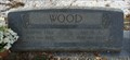
| Aaron Hill Wood - Ebenezer Cemetery - Greenville, AL in Woodmen of the World Grave Markers/Monuments WOW monument for Aaron Hill Wood born in 1873 and died in 1956. posted by: hoteltwo location: Alabama date approved: 12/14/2013 last visited: never |
 view gallery view gallery E7.7 km E7.7 km
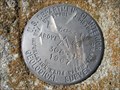
|  US Geological Survey elevation marker 420 FT 30B-12 1967 US Geological Survey elevation marker 420 FT 30B-12 1967
in U.S. Benchmarks USGS elevation benchmark at Pleasant Home Church posted by: jkselby location: Alabama date approved: 02/25/2008 last visited: never |
 view gallery view gallery W7.9 km W7.9 km
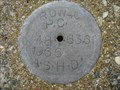
| Ala. State Hwy. Dept. ROW P.C. 40 48+63.6 1966 in U.S. Benchmarks Alabama Highway Dept. Right of Way marker in Butler County posted by: jkselby location: Alabama date approved: 03/17/2008 last visited: 03/17/2012 |
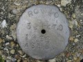 view gallery view galleryW8.2 km | Ala. State Hwy. Dept. ROW 40 39+470 1966 in U.S. Benchmarks Alabama Highway Department ROW marker in Butler County posted by: jkselby location: Alabama date approved: 03/10/2008 last visited: 03/17/2012 |
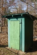 view gallery view galleryW8.9 km |  Mt. Olive East Church Outhouse Mt. Olive East Church Outhouse
in Outhouses Two seater outhouse at a rural church in LA (lower Alabama). posted by:  OHail OHail location: Alabama date approved: 01/19/2012 last visited: 03/09/2012 |
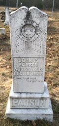 view gallery view galleryS14.5 km | John P. Parson - Oakey Streak Cemetery - Oakey Streak, AL in Woodmen of the World Grave Markers/Monuments WOW monument for John P. Parson born Aug. 28, 1882 and died Dec. 18, 1929. posted by: hoteltwo location: Alabama date approved: 12/14/2013 last visited: never |
 view gallery view gallery NW14.5 km NW14.5 km
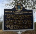
|  Pioneer Electric Cooperative - Greenville, AL Pioneer Electric Cooperative - Greenville, AL
in Alabama Historical Markers Marker describes the first home hooked up to the local rural cooperatives electrical grid near Greenville Alabama in 1938. posted by: hoteltwo location: Alabama date approved: 12/14/2013 last visited: never |
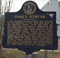 view gallery view galleryS14.5 km | Oakey Streak - Butler County, AL in Alabama Historical Markers Marker describes the early settling of a community named Oakey Streak, in lower rural Butler County, off County Road 59. posted by: hoteltwo location: Alabama date approved: 12/14/2013 last visited: never |
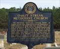 view gallery view galleryS14.5 km | Oakey Streak Methodist Church - Butler County, AL in Alabama Historical Markers Marker describes history of this historic church. The church and cemetery next to it are on the National Register of Historic Places. posted by: hoteltwo location: Alabama date approved: 12/14/2013 last visited: never |
 view gallery view galleryW17.1 km | Early Native Americans in Butler County - Chapman, AL in Alabama Historical Markers This 2-sided marker is located about 8 miles south of Greenville at MM-128 on US-231. It describes the history behind the Native American societies that made up this area of present-day Butler County, Alabama. posted by: hoteltwo location: Alabama date approved: 07/17/2024 last visited: never |
 view gallery view galleryW17.1 km | Indian Trails and Travelers in Butler County - Chapman, AL in Alabama Historical Markers This 2-sided marker is located about 8 miles south of Greenville at MM-128 on US-231. It notes the history of the trails and paths made by Native Americans, explorers and later settlers. posted by: hoteltwo location: Alabama date approved: 07/17/2024 last visited: never |
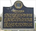 view gallery view galleryE19.5 km | Rutledge in Alabama Historical Markers Rutledge was the original county seat of Crenshaw County until the railroad passed it by. posted by: vhasler location: Alabama date approved: 12/01/2010 last visited: 03/02/2014 |
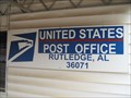 view gallery view galleryE19.5 km |  Rutledge, AL - 36071 Rutledge, AL - 36071
in U.S. Post Offices Small town post office in rural Alabama posted by: vhasler location: Alabama date approved: 12/21/2010 last visited: 03/09/2012 |
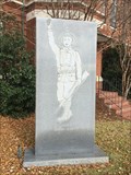 view gallery view galleryNW19.6 km |  Butler County World War I Memorial - Greenville, AL Butler County World War I Memorial - Greenville, AL
in World War I Memorials and Monuments Located on the Butler County Courthouse grounds this simple upright monolith memorial is dedicated to those who gave their lives during the Great War. posted by: hoteltwo location: Alabama date approved: 12/15/2013 last visited: 01/27/2023 |
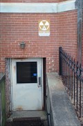 view gallery view galleryNW19.6 km |  Butler County Courthouse - Greenville, AL Butler County Courthouse - Greenville, AL
in Civil Defense Fallout Shelters The east basement entrance to the Butler County Courthouse is a fallout shelter - in Greenville, Alabama. posted by: The Snowdog location: Alabama date approved: 01/28/2023 last visited: never |
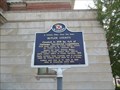 view gallery view galleryNW19.6 km | A County Older Than the State/Butler County - Greenville, AL in Alabama Historical Markers This two-sided marker is located on the grounds of the Butler County Courthouse, to the right of the entrance facing the downtown area on East Commerce Street. posted by: xptwo location: Alabama date approved: 08/12/2013 last visited: 01/27/2023 |
 view gallery view galleryNW19.6 km |  Bullock County Courhouse - East Commerce Street Historic District - Greenville, AL Bullock County Courhouse - East Commerce Street Historic District - Greenville, AL
in NRHP Historic Districts - Contributing Buildings The Bullock County Courthouse is located in a roundabout at the intersection of East Commerce Street and Conecuh Street. It was included as a contributing building in the 1986 district application. posted by: xptwo location: Alabama date approved: 08/14/2013 last visited: 01/27/2023 |
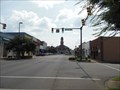 view gallery view galleryNW19.6 km |  East Commerce Street Historic District - Greenville, AL East Commerce Street Historic District - Greenville, AL
in U.S. National Register of Historic Places The district is roughly bounded by Cedar, Chestnut, Commerce, and Hickory Streets in Greenville, AL. The Butler County Courthouse is the most prominent building in the district. posted by: xptwo location: Alabama date approved: 08/10/2013 last visited: 01/27/2023 |
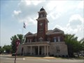 view gallery view galleryNW19.6 km | Butler County Courthouse Dome (BU1876) - Greenville, AL in U.S. Benchmarks The dome on the Butler County Courthouse in Greenville, Alabama, was used for surveying purposes in 1944. posted by: xptwo location: Alabama date approved: 08/10/2013 last visited: 01/27/2023 |
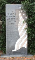 view gallery view galleryNW19.8 km |  Vietnam War Memorial, Courthouse Grounds, Greenville, AL, USA Vietnam War Memorial, Courthouse Grounds, Greenville, AL, USA
in Vietnam War Memorials Located on the Butler County Courthouse grounds at 700 Court Square, this monument is dedicated to those KIA in the Vietnam War. posted by: hoteltwo location: Alabama date approved: 12/25/2013 last visited: 01/27/2023 |
 view gallery view galleryNW19.8 km |  Desert Storm Memorial - Greenville, AL Desert Storm Memorial - Greenville, AL
in Persian Gulf War Memorials This memorial to those who served in Desert Storm is located outside the Butler County Courthouse in Greenville, Alabama. posted by: xptwo location: Alabama date approved: 10/27/2013 last visited: 01/27/2023 |
|