 view gallery view gallery NE18.3 km NE18.3 km
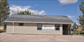
|   Cloverdale, New Mexico Cloverdale, New Mexico
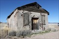
in Ghost Towns Cloverdale, New Mexico townsite posted by:  outwest63 outwest63 location: New Mexico date approved: 02/28/2012 last visited: never |
 view gallery view gallery W19.6 km W19.6 km
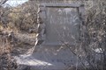
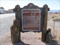
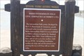
|  Mormon Batallion Passed Here Mormon Batallion Passed Here
in Arizona Historical Markers The Mormon Battalion was activated on July 1846 to assist in the war with Mexico. They traveled from Council Bluffs, Iowa to San Diego, California. The Battalion was deactivated in July, 1847. posted by: outwest63 location: Arizona date approved: 02/06/2011 last visited: never |
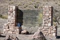
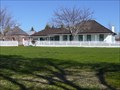 view gallery view galleryW20.6 km |  San Bernardino Ranch - Douglas, AZ San Bernardino Ranch - Douglas, AZ
in U.S. National Register of Historic Places Much history abounds in this Old West which really has not changed all that much. It is still remote, laid-back and beautiful, as it separates itself from the hectic life of the big city. posted by:  leadhiker leadhiker location: Arizona date approved: 05/17/2010 last visited: never |
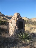 view gallery view gallery N21.4 km N21.4 km
|  NM / AZ on Geronimo Trail NM / AZ on Geronimo Trail
in Border Crossings A 2 meter high stone and mortar monument with a bronze plaque on a remote dirt road in the beautiful Hog Canyon in the rugged deep southwest of New Mexico; deep southeast of Arizona. posted by: Scrawlinn location: New Mexico date approved: 04/21/2009 last visited: 11/07/2017 |
 view gallery view galleryW21.7 km | Mormon Battalion in Arizona Historical Markers The Mormon Battalion was the only religious unit in American military history, serving from July 1846 to July 1847 during the Mexican-American War. The battalion made a grueling 2000 mile march from Council Bluffs, Iowa to San Diego, California. posted by: leadhiker location: Arizona date approved: 05/14/2010 last visited: 01/26/2011 |
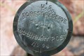
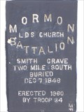
 view gallery view galleryN22.7 km |  U.S. Mormon Battalion Trail Historical Marker No. 7 U.S. Mormon Battalion Trail Historical Marker No. 7
in New Mexico Historical Markers Historical Marker No. 7
U. S. Mormon Battalion Trail
History of Trek Though Mountains
Located on Geronimo Trail in South West Hidalgo County New Mexico posted by: outwest63 location: New Mexico date approved: 02/26/2012 last visited: 11/07/2017 |
 view gallery view galleryN22.7 km |  Mormon Battalion Trail Marker No. 7 Mormon Battalion Trail Marker No. 7
in Smithsonian Art Inventory Sculptures The Mormon Battalion Trail Marker No. 7 is a Wood and Stone monument located on the Geronimo Trail. The marker is in Hidalgo County, New Mexico South of Annimas, New Mexico posted by: outwest63 location: New Mexico date approved: 03/22/2012 last visited: 11/07/2017 |
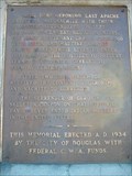
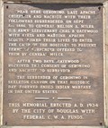
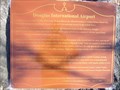 view gallery view galleryW42.6 km | Douglas International Airport in Arizona Historical Markers The first and only truly international airport in the America's, Douglas International Airport began operations in 1929. The Douglas airfield was connected with the Auga Prieta, Mexico, airport by a common north-south runway. posted by: leadhiker location: Arizona date approved: 05/17/2010 last visited: never |
 view gallery view galleryN43.6 km | Geronimo Surrender Monument in Arizona Historical Markers On Route 80 south of Rodeo, New Mexico, near Apache, Arizona, stands a marker commemorating Geronimo's surrender. A short distance south of the marker is a road which leads east and then south/southeast to the actual surrender site. posted by: leadhiker location: Arizona date approved: 05/17/2010 last visited: 06/17/2012 |
 view gallery view galleryN43.6 km |  Last Apache Chieftain Last Apache Chieftain
in Last of its Kind Geronimo was the last Apache Chieftain to wage war against the white man. posted by: brwhiz location: Arizona date approved: 11/27/2012 last visited: never |
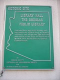 view gallery view galleryW46.5 km | Library Hall the Douglas Public Library in Arizona Historical Markers This was one of the first buildings in Douglas. It has been in continuous use for over 80 years and moved twice. The first time it was moved was from Pan American & 10th St. to 10th St. and F Ave. The last move was to make room for the Post Office. posted by: leadhiker location: Arizona date approved: 05/17/2010 last visited: never |
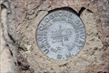
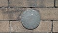 view gallery view galleryW47 km |  US Geological Survey B.M. CF0142 - Douglas, Az. US Geological Survey B.M. CF0142 - Douglas, Az.
in U.S. Benchmarks US Geological Survey B.M. located at the Douglas, Az. Police Department. posted by: outwest63 location: Arizona date approved: 10/31/2013 last visited: never |
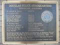 view gallery view galleryW47 km | Douglas Police Headquarters in Arizona Historical Markers Built as the El Paso & Southwestern Railroad Depot, the two story Beaux Arts Classic Revival style depot saw as many as eight passenger trains a day in the 1920's. posted by: leadhiker location: Arizona date approved: 05/17/2010 last visited: 06/15/2012 |
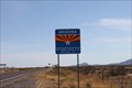
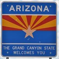 view gallery view galleryN56 km |  Arizona ~ The Grand Canyon State Arizona ~ The Grand Canyon State
in Welcome Signs This Welcome Sign greets you when you cross the border from New Mexico on New Mexico/Arizona Highway 80 southwest of Rodeo, New Mexico. posted by: brwhiz location: Arizona date approved: 02/16/2013 last visited: 06/05/2013 |
 view gallery view galleryN56 km |  Arizona/New Mexico State Boundary Marker - State Route 80 - Arizona Arizona/New Mexico State Boundary Marker - State Route 80 - Arizona
in Public Land Survey Marks A marker along Arizona State Route 80/New Mexico State Road 80 that marks the boundary between Arizona and New Mexico. posted by: adenium location: Arizona date approved: 07/19/2012 last visited: 10/16/2012 |
 view gallery view galleryN56 km | AZ/NM - Highway 80 in Border Crossings Border crossing between Arizona and New Mexico on Highway 80. posted by: outwest63 location: Arizona date approved: 04/16/2011 last visited: 09/25/2017 |
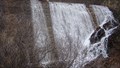 view gallery view gallery NW57.3 km NW57.3 km
|  Falls at Rucker Lake Falls at Rucker Lake
in Man-made Waterfalls Roper Lake was filled in from debris caused by the Rattlesnake Fire in the late 1992. The stream now flows over the Dam. posted by: outwest63 location: Arizona date approved: 11/03/2010 last visited: 05/15/2010 |
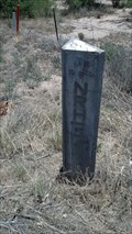
 view gallery view galleryNW57.6 km | US Forest Reserve Boundry Marker No. 96 in Public Land Survey Marks The Boundry marker is located South East of the Forestry Camp in Rucker Canyon posted by: outwest63 location: Arizona date approved: 11/02/2013 last visited: never |
 view gallery view galleryN58.6 km |  Rodeo, New Mexico 88056 Rodeo, New Mexico 88056
in U.S. Post Offices This Post Office is located at 16 Custie Avenue in Rodeo, New Mexico. posted by: brwhiz location: New Mexico date approved: 11/06/2011 last visited: never |
 view gallery view galleryN58.9 km | Rodeo Station in New Mexico Historical Markers Another town whose past history was tied to the railroad, but whose modern history is also fascinating. posted by: linkys location: New Mexico date approved: 12/17/2009 last visited: 06/11/2018 |
 view gallery view galleryW62.3 km | Mormon Battalion in Arizona Historical Markers The Mormon Battalion was the only religious unit in American military history, serving from July 1846 to July 1847 during the Mexican-American War. The battalion made a grueling 2000 mile march from Council Bluffs, Iowa to San Diego, California. posted by: leadhiker location: Arizona date approved: 05/14/2010 last visited: 04/05/2011 |
 view gallery view galleryW67.8 km | International Boundary Monument 89 in U.S. Benchmarks International Boundary Monument 89 posted by: outwest63 location: Arizona date approved: 04/06/2011 last visited: never |
 view gallery view galleryN68.2 km | Rodeo Intermediate Field Civil Aeronautics Authority #57A in New Mexico Historical Markers The Rodeo Intermediate Field Civil Aeronautics Authority Field #57A is located at the intersection of N.M. highways 80 and 9. posted by: outwest63 location: New Mexico date approved: 06/24/2013 last visited: 06/11/2018 |
 view gallery view galleryN70.5 km | Buena Vista Peak USGS BM - Cochise County, Az. in U.S. Benchmarks The disk is located on the site of the remains of the Barfoot Look Out Tower on Buena Vista Peak. Buena Vista Peak is located in the Chiricahua Mountains in South Eastern Arizona. posted by: outwest63 location: Arizona date approved: 06/21/2013 last visited: 05/27/2023 |
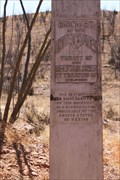
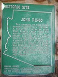 view gallery view galleryNW70.7 km | John Ringo in Arizona Historical Markers For more than a century, mystery and controversy have circulated about the details of Ringo's demise, making his death one of the most hotly debated deaths in Old West history.
This site is on private property. Please obey all signs. posted by: leadhiker location: Arizona date approved: 05/17/2010 last visited: 04/22/2011 |
|