 view gallery view gallery N42.2 km N42.2 km
|   Coronado National Memorial - Hereford AZ Coronado National Memorial - Hereford AZ
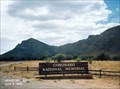
in U.S. National Register of Historic Places Coronado National Monument was established in 1952 to commemorate the first major Spanish exploration into the American Southwest, the Francisco Vasquez de Coronado expedition of 1540-42. posted by:  Don.Morfe Don.Morfe location: Arizona date approved: 02/19/2022 last visited: 02/16/2022 |
 view gallery view galleryN42.2 km | ") Coronado National Monument - Hereford AZ Coronado National Monument - Hereford AZ
in National Parks (U.S.) Coronado National Monument was established in 1952 to commemorate the first major Spanish exploration into the American Southwest, the Francisco Vasquez de Coronado expedition of 1540-42. posted by: Don.Morfe location: Arizona date approved: 11/20/2020 last visited: 02/16/2022 |
 view gallery view galleryN42.2 km |  Coronado National Monument - Hereford AZ Coronado National Monument - Hereford AZ
in National Parks of the World Coronado National Monument was established in 1952 to commemorate the first major Spanish exploration into the American Southwest, the Francisco Vasquez de Coronado expedition of 1540-42. posted by: Don.Morfe location: Arizona date approved: 02/15/2022 last visited: 02/16/2022 |
 view gallery view galleryN42.2 km |  Coronado National Monument - Hereford AZ Coronado National Monument - Hereford AZ
in Official Local Tourism Attractions Coronado National Monument was established in 1952 to commemorate the first major Spanish exploration into the American Southwest, the Francisco Vasquez de Coronado expedition of 1540-42. posted by: Don.Morfe location: Arizona date approved: 02/15/2022 last visited: 02/16/2022 |
 view gallery view galleryN42.2 km |  Coronado National Monument - Hereford AZ Coronado National Monument - Hereford AZ
in Satellite Imagery Oddities Coronado National Monument was established in 1952 to commemorate the first major Spanish exploration into the American Southwest, the Francisco Vasquez de Coronado expedition of 1540-42. posted by: Don.Morfe location: Arizona date approved: 02/15/2022 last visited: 02/16/2022 |
 view gallery view galleryN42.2 km |  Coronado National Memorial Coronado National Memorial
in NPS Passport Cancellation Stations Coronado National Memorial, near Sierra Vista, Arizona, commemorates the first organized expedition into the Southwest by conquistador Francisco Vásquez de Coronado. posted by: leadhiker location: Arizona date approved: 03/10/2010 last visited: 03/05/2023 |
 view gallery view galleryN42.3 km |  Coronado National Memorial - Hereford AZ Coronado National Memorial - Hereford AZ
in Wikipedia Entries The Coronado National Memorial commemorates the first organized expedition into the Southwest by conquistador Francisco Vásquez de Coronado in 1540. posted by: Don.Morfe location: Arizona date approved: 02/15/2022 last visited: 02/16/2022 |
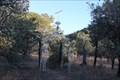
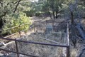
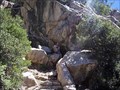 view gallery view galleryN43.1 km | ") Coronado Cave Coronado Cave
in Cave Entrances (Natural) Small dry cave located in Coronado National Memorial; great cave to introduce others to spelunking.
posted by: Megadrile location: Arizona date approved: 02/17/2008 last visited: 11/30/2017 |
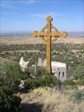 view gallery view galleryN46 km |  Our Lady of the Sierras Shrine Cross - Hereford, AZ Our Lady of the Sierras Shrine Cross - Hereford, AZ
in Christian Crosses A seventy-five foot Celtic Cross located at the Our Lady of the Sierras Shrine in Hereford, AZ, USA. posted by:  HiFiLZ HiFiLZ location: Arizona date approved: 05/04/2008 last visited: 04/01/2015 |
 view gallery view galleryN46.2 km |  Our Lady of the Sierras Shrine Stations of the Cross - Hereford, AZ Our Lady of the Sierras Shrine Stations of the Cross - Hereford, AZ
in Outdoor Stations of the Cross Outdoor Stations of the Cross located on the grounds of the Our Lady of the Sierras Shrine. posted by: HiFiLZ location: Arizona date approved: 05/26/2008 last visited: 07/13/2014 |
 view gallery view galleryN51.3 km |  Smokey Bear near the Mexican border in southern Arizona Smokey Bear near the Mexican border in southern Arizona
in Smokey Bear Sign Sightings This Smokey Bear is at the junction of Montezuma Canyon and Sunnyside Roads near Parker Canyon lake in SE Arizona. posted by: tugies location: Arizona date approved: 12/14/2013 last visited: 12/25/2013 |
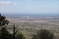 view gallery view galleryN51.5 km |  Sierra Vista, Az. from Carr Canyon Road Sierra Vista, Az. from Carr Canyon Road
in Cityscapes Looking North East from the top of Carr Canyon road. posted by: outwest63 location: Arizona date approved: 11/11/2010 last visited: 04/05/2013 |
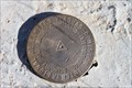 view gallery view gallery NW51.8 km NW51.8 km
|  International Boundary and Water Commission International Boundary and Water Commission
in U.S. Benchmarks This marker is located on a hill approximately 200 feet north of the border between Mexico and the United States in Santa Cruz County, Arizona. posted by: outwest63 location: Arizona date approved: 01/17/2011 last visited: never |
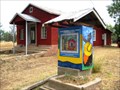 view gallery view galleryNW51.8 km |  Lochiel Schoolhouse, Santa Cruz County, AZ Lochiel Schoolhouse, Santa Cruz County, AZ
in One-Room Schoolhouses One room adobe schoolhouse in southern Arizona near the Mexican border. posted by: tugies location: Arizona date approved: 10/17/2014 last visited: 12/31/2014 |
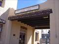 view gallery view gallery NE52 km NE52 km
| Naco Border Station - Naco, AZ in U.S. National Register of Historic Places The Naco Port of Entry (POE) is located in southern Cochise County, approximately six miles south of Bisbee, 35 miles west of Douglas, and directly across the border from Naco, Sonora, Mexico. posted by: leadhiker location: Arizona date approved: 05/11/2010 last visited: never |
 view gallery view galleryN52.1 km |  Sunnyside Cemetary, Az Sunnyside Cemetary, Az
in Abandoned Cemeteries The cemetary was established by the citizens of the nearby ghost town of Sunnyside. posted by: outwest63 location: Arizona date approved: 01/24/2012 last visited: 06/20/2021 |
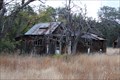 view gallery view galleryN52.8 km |  Sunnyside, Az. Sunnyside, Az.
in Ghost Towns Sunnyside is a ghost town located on the West side of the Huachuca Mountains in South East Arizona. posted by: outwest63 location: Arizona date approved: 01/23/2012 last visited: 12/12/2013 |
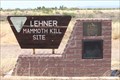 view gallery view galleryN52.9 km |  Lehner Mammoth Kill Site Lehner Mammoth Kill Site
in Arizona Historical Markers The Lehner Mammoth Kill site was donated to the Interior Department Bureau of Land Management by the Lehner family. posted by: outwest63 location: Arizona date approved: 06/25/2011 last visited: never |
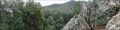 view gallery view galleryN54.1 km |  Brown Canyon Rock Waves Brown Canyon Rock Waves
in Places of Geologic Significance Rocks forming an S-curve next to a waterfall. posted by: Phydux location: Arizona date approved: 04/19/2014 last visited: 05/10/2014 |
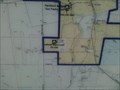 view gallery view galleryN54.7 km |  Trail Head for San Pedro River Walk Trail Head for San Pedro River Walk
in 'You Are Here' Maps This is the location of the Southern end of the San Pedro River Walk. The walk heads North towards Benson, Az. posted by: outwest63 location: Arizona date approved: 11/04/2010 last visited: never |
 view gallery view galleryN55.2 km |  W. H. Frierson W. H. Frierson
in Out of Place Graves Grave site for W. H. Frierson posted by: outwest63 location: Arizona date approved: 01/23/2012 last visited: 06/24/2014 |
 view gallery view galleryN55.4 km | Hereford, Az. in Wikipedia Entries Hereford, Az. is located in Cochise County, Arizona. Approximately 6700 people live in the area. Hereford was originally a train station for the Southern Pacific Rail Road. The original train station has been abandoned. posted by: outwest63 location: Arizona date approved: 11/04/2010 last visited: never |
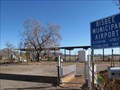 view gallery view galleryNE58.9 km |  Bisbee Municipal Airport - Bisbee, AZ Bisbee Municipal Airport - Bisbee, AZ
in Airports Small airport serving the town of Bisbee and the surrounding areas of Cochise County. posted by: linkys location: Arizona date approved: 01/07/2010 last visited: 08/18/2013 |
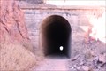 view gallery view galleryNE60.4 km |  El Paso and Southwestern Bisbee Tunnel (Crook Tunnel) El Paso and Southwestern Bisbee Tunnel (Crook Tunnel)
in Abandoned Train Tunnels The tunnel was built by the El Paso and Southwestern in 1902. posted by: outwest63 location: Arizona date approved: 02/02/2011 last visited: 06/30/2020 |
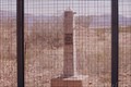 view gallery view galleryNE60.4 km | International Boundary Marker 90 in U.S. Benchmarks International Boundary Marker Number 90 posted by: outwest63 location: Arizona date approved: 04/06/2011 last visited: never |
|