 view gallery view gallery S2.4 km S2.4 km
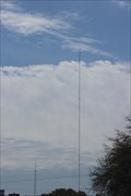
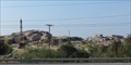
|   KHSB-FM 104.7 -- Marble Falls TX USA KHSB-FM 104.7 -- Marble Falls TX USA
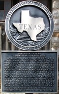
in Radio and Television Transmitter Towers KHSB (K-HorseShoe Bay) is a Christian Talk Radio station located a few miles north of Marble Falls along the US 281 posted by:  Benchmark Blasterz Benchmark Blasterz location: Texas date approved: 03/20/2023 last visited: 03/21/2023 |
 view gallery view gallery SW4.7 km SW4.7 km
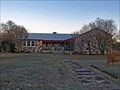
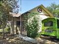
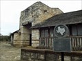
|  Fairland School - Marble Falls, TX Fairland School - Marble Falls, TX
in Former Schools Rubble rock construction building. posted by:  WalksfarTX WalksfarTX location: Texas date approved: 01/01/2020 last visited: never |
 view gallery view gallerySW4.7 km |  Fairland School (Former) - Marble Falls, TX Fairland School (Former) - Marble Falls, TX
in WPA Projects Rubble rock construction building. posted by: WalksfarTX location: Texas date approved: 01/29/2020 last visited: never |
 view gallery view gallery W6.8 km W6.8 km
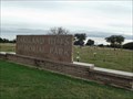
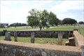
|  Lakeland Hills Memorial Park - Burnet, TX Lakeland Hills Memorial Park - Burnet, TX
in Worldwide Cemeteries Located between Burnet, Marble Falls and Kingsland on Park Rd 4. posted by: WalksfarTX location: Texas date approved: 12/18/2021 last visited: never |
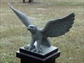 view gallery view galleryW6.8 km |  Eagle - Burnet, TX Eagle - Burnet, TX
in Figurative Public Sculpture Eagle on black pedestal near the cemetery entrance. posted by: WalksfarTX location: Texas date approved: 12/13/2021 last visited: never |
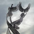 view gallery view galleryW6.8 km | Three Doves - Burnet, TX in Figurative Public Sculpture Sculpture is located in Lakeland Hills Memorial Park. posted by: WalksfarTX location: Texas date approved: 12/13/2021 last visited: never |
 view gallery view gallery NE7.6 km NE7.6 km
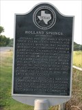
|  Holland Springs Holland Springs
in Texas Historical Markers The marker is about the nearby springs. posted by: Deafdillos location: Texas date approved: 10/02/2007 last visited: 08/05/2012 |
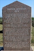 view gallery view gallerySW8.5 km | Granite Mountain in Texas Historical Markers A pink granite marker by a TX DoT rest area on FM-1431 just west of Marble Falls (Burnet County) overlooking the quarrying mine of Granite Mountain -- located .25mi south of the rest area. posted by: Raven location: Texas date approved: 10/27/2020 last visited: 10/10/2020 |
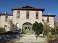 view gallery view galleryS9 km | Granite School Building - Marble Falls, TX in Former Schools The Old Granite School was converted to administrative offices in 1982. It is now The Falls on the Colorado Museum posted by: WalksfarTX location: Texas date approved: 12/12/2020 last visited: never |
 view gallery view gallerySW9 km |  LARGEST -- Pink Granite Quarry in the USA - Marble Falls, TX LARGEST -- Pink Granite Quarry in the USA - Marble Falls, TX
in Superlatives Granite Mountain in Marble Falls, TX boasts to be the largest quarry of solid pink granite in the USA. Excavations started in the 1880's and not much is left of the original 'mountain', but operations are still ongoing to date. posted by: Raven location: Texas date approved: 10/26/2020 last visited: 10/10/2020 |
 view gallery view galleryS9.3 km |  A&NW Depot - Marble Falls, TX A&NW Depot - Marble Falls, TX
in Train Stations/Depots Wood combination passenger/freight depot from 1893. It is now used as a bus depot by Capital Area Rural Transportation System (CARTS). posted by: WalksfarTX location: Texas date approved: 09/17/2017 last visited: never |
 view gallery view gallery N9.3 km N9.3 km
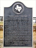
| Magill Family Cemetery in Texas Historical Markers This subject marker stands in front of the little cemetery, which is located just inside the gate to Burnet Municipal Airport (Kate Craddock Field), on the west side of S Water Street in Burnet. posted by: QuesterMark location: Texas date approved: 12/08/2013 last visited: 10/10/2022 |
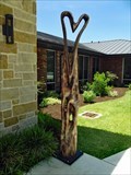 view gallery view galleryS9.3 km |  Wood Heart - Marble Falls, TX Wood Heart - Marble Falls, TX
in Outside Wooden Display Carvings Located at the corner of building - home of the Helping Center. posted by: WalksfarTX location: Texas date approved: 06/18/2022 last visited: never |
 view gallery view galleryN9.3 km | Magill Family Cemetery -- Burnet TX in Worldwide Cemeteries A small pioneer family cemetery at the local airport just off the US 183 posted by: Benchmark Blasterz location: Texas date approved: 03/03/2014 last visited: 10/10/2022 |
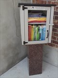 view gallery view galleryS9.3 km |  Helping Center Learn 4 Life Library - Marble Falls, TX Helping Center Learn 4 Life Library - Marble Falls, TX
in Free Community Book Exchanges 30.57715, -98.2762 Located down a stairwell in an outdoor patio seating area. posted by: WalksfarTX location: Texas date approved: 06/13/2022 last visited: never |
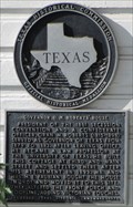 view gallery view galleryS9.5 km | Governor O. M. Roberts' House in Texas Historical Markers This medalliona and plate marker is attached to the front of the little house at 819 7th St. less than a block east of SH 281 in Marble Falls. posted by: QuesterMark location: Texas date approved: 07/06/2015 last visited: 06/13/2015 |
 view gallery view galleryS9.5 km |  CV4717 - "MARBLE FALLS RM 2" reference mark disk - Marble Falls, TX CV4717 - "MARBLE FALLS RM 2" reference mark disk - Marble Falls, TX
in U.S. Benchmarks This benchmark is located in a fenced-in area around an old 1956 water tank (which itself is a NGS benchmark as well: BN0599) on Villa Viejo at the eastern edge of Marble Falls, TX. posted by: Raven location: Texas date approved: 04/23/2015 last visited: 08/15/2014 |
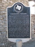
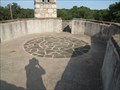 view gallery view galleryW9.8 km |  Longhorn Cavern Administration Building Rooftop Compass Rose - Marble Falls, TX Longhorn Cavern Administration Building Rooftop Compass Rose - Marble Falls, TX
in Compass Roses This building was constructed by the Civilian Conservation Corps. It was completed in 1936. The building has an observation terrace on the roof. The observation terrace has a compass rose in it. posted by: QuesterMark location: Texas date approved: 09/23/2016 last visited: 12/13/2021 |
 view gallery view galleryW9.8 km |  Longhorn Cavern Administration Building - Burnet, TX Longhorn Cavern Administration Building - Burnet, TX
in Civilian Conservation Corps This medallion and plate is mounted to a post standing in front of the right side of the building now known as the CCC Exhibit Hall. posted by: WalksfarTX location: Texas date approved: 12/13/2021 last visited: never |
 view gallery view galleryW9.8 km | Longhorn Cavern Administration Building in Texas Historical Markers This medallion and plate is mounted to a post standing in front of the right side of the building now known as the CCC Exhibit Hall. posted by: QuesterMark location: Texas date approved: 11/25/2013 last visited: 12/13/2021 |
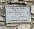 view gallery view galleryW9.8 km |  Longhorn Cavern State Park Administration Building - 1967 - Burnet, TX Longhorn Cavern State Park Administration Building - 1967 - Burnet, TX
in Dated Architectural Structures Multifarious Metal plaque on the building. posted by: WalksfarTX location: Texas date approved: 12/13/2021 last visited: never |
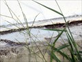
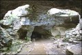 view gallery view galleryW9.8 km | ") Longhorn Cavern - Burnet, Texas Longhorn Cavern - Burnet, Texas
in Cave Entrances (Natural) Longhorn Cavern offers guided tours every day of the week. Tours last about an hour and twenty five minutes. On site guides lead you through the cavern narrating historical and geologic facts.
posted by: txoilgas location: Texas date approved: 01/30/2009 last visited: 06/29/2018 |
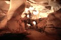 view gallery view galleryW9.8 km |  Longhorn Cavern State Park - Burnet, Texas Longhorn Cavern State Park - Burnet, Texas
in State/Provincial Parks Our earliest records indicate that the Comanche Indians were the first to use the cavern. They came in about 400 years or so before anyone else did.
posted by: txoilgas location: Texas date approved: 01/30/2009 last visited: 12/13/2021 |
 view gallery view galleryW9.8 km | Longhorn Cavern - Burnet, Texas in Civilian Conservation Corps The Civilian Conservation Corps (CCC) began work at Longhorn Cavern in the 1930s, many of the cavern's chambers were filled with dozens of feet of silt and debris. posted by: txoilgas location: Texas date approved: 02/01/2009 last visited: 03/27/2019 |
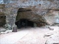
 view gallery view galleryW9.8 km | Longhorn Caverns in Texas Historical Markers The entrance of a very intersting cavern. posted by: txoilgas location: Texas date approved: 02/22/2009 last visited: 12/13/2021 |
|