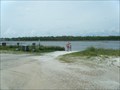
 view gallery view gallery S0.6 km S0.6 km
|   Small boat/canoe launch, St. George Island S.P., Florida Small boat/canoe launch, St. George Island S.P., Florida
in Boat Ramps An unimproved, sand ramp launching into East Slough, St George Sound. posted by:  garmin_geek garmin_geek location: Florida date approved: 08/31/2013 last visited: 03/08/2018 |
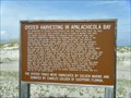 view gallery view galleryS0.6 km |  Oyster Harvesting in Apalachicola Bay Oyster Harvesting in Apalachicola Bay
in Signs of History Sign and Oyster boat located at a small boat launch in St. Georges State Park. posted by: garmin_geek location: Florida date approved: 09/08/2013 last visited: 03/08/2018 |
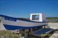 view gallery view galleryS0.6 km |  Oyster Skiff, St. George Island, Fl. Oyster Skiff, St. George Island, Fl.
in Landlocked Boats An oyster skiff displayed at Dr. Julian G. Bruce St. George Island State Park, St. George island, Fl.
posted by:  dimples1 dimples1 location: Florida date approved: 11/10/2009 last visited: 03/08/2018 |
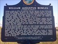 view gallery view gallery SW3.5 km SW3.5 km
|  William Augustus Bowles William Augustus Bowles
in Florida Historical Markers Bowles hoped to create an independent Indian nation in Spanish Florida centered on the Wakulla River. Along the way he traveled around the world. posted by: Data Wrangler location: Florida date approved: 09/04/2012 last visited: 08/06/2019 |
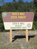 view gallery view gallery N8.2 km N8.2 km
|  Big Bend Scenic Byway - Tate's Hell State Forest - Carrabelle, Florida. Big Bend Scenic Byway - Tate's Hell State Forest - Carrabelle, Florida.
in National Scenic Byways Tate's Hell State Forest with over 800 miles of roads trails, & tracks in Franklin & Liberty counties. The forest is located at Easpoint, near Carrabelle off the Big Bend Scenic Byway (US 98) along the gulf coast, Northern Florida. posted by: veritas vita location: Florida date approved: 01/27/2018 last visited: 01/31/2018 |
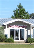 view gallery view gallery NW9.8 km NW9.8 km
| Big Bend Scenic Byway - Tourist Info Center - Eastpoint, Florida, USA. in National Scenic Byways Franklin County Tourist Development Council & Visitor Center.
Promoting the coastal communities of Alligator Point, Apalachicola, Carrabelle, Eastpoint & St.George Island. Located alongside the Big Bend Scenic Highway Coastal Trail- Northern Florida posted by: veritas vita location: Florida date approved: 12/28/2017 last visited: 11/26/2017 |
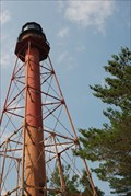
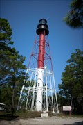
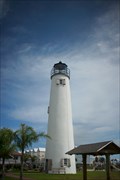 view gallery view gallerySW10.3 km |  Cape St. George Light - St. George Island, FL Cape St. George Light - St. George Island, FL
in U.S. National Register of Historic Places Located at the S point of Little St. George Island, Little St. George Island,Fla. posted by: Coinseekers location: Florida date approved: 09/30/2009 last visited: 06/08/2020 |
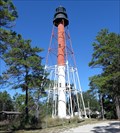
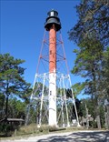
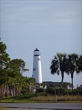 view gallery view gallerySW10.3 km |  St. George Island Lighthouse St. George Island Lighthouse
in Coastal Lighthouses The St. George Island lighthouse has been salvaged and restored at an inland location at the center of St. George Island, Florida. posted by: no_angel location: Florida date approved: 03/15/2009 last visited: 06/08/2020 |
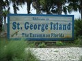 view gallery view gallerySW10.3 km |  Welcome to St. George Island ~ The Uncommon Florida Welcome to St. George Island ~ The Uncommon Florida
in Welcome Signs Just across the bridge as you arrive on the island. posted by: garmin_geek location: Florida date approved: 09/03/2013 last visited: 06/08/2020 |
 view gallery view gallery W12.1 km W12.1 km
|  Apalachicola National Estuarine Research Reserve, Florida Apalachicola National Estuarine Research Reserve, Florida
in Research Institutes Apalachicola National Estuarine Research Reserve, designated in 1979 is a Environmental Education and Training Center located in the Florida Bay Area and is a great place to visit during early spring and summer posted by: srinidhilv location: Florida date approved: 02/15/2015 last visited: 01/29/2015 |
 view gallery view gallery NE15.1 km NE15.1 km
| Big Bend Scenic Highway - Crooked River Lighthouse - Carrabelle, Florida, USA. in National Scenic Byways The Big Bend Scenic Byway is made up of two distinct corridors, the Forest Trail & Coastal Trail. The Crooked River Lighthouse, (Carrabelle Light) is one of the central, Coastal Trail historic highlights. Located near Carrabelle, North Florida, USA posted by: veritas vita location: Florida date approved: 12/22/2017 last visited: 11/19/2020 |
 view gallery view galleryNE15.1 km | Crooked River Lighthouse in Coastal Lighthouses The Crooked River Lighthouse is located near the city of Carrabelle, Florida. Although the tower is closed to the public, a nice park allows great viewing and photographs of the lighthouse. posted by: moochie location: none listed yet date approved: 05/22/2007 last visited: 11/19/2020 |
 view gallery view galleryNE15.1 km |  Crooked River Light - Carrabella, Florida, USA. Crooked River Light - Carrabella, Florida, USA.
in Wikipedia Entries The Crooked River Lighthouse, (Carrabelle Light) Stands in a small park alongside the Big Bend Scenic Byway. Near the City of Carrabelle, North Florida, USA. posted by: veritas vita location: Florida date approved: 12/22/2017 last visited: 11/19/2020 |
 view gallery view galleryNE15.1 km | Crooked River Lighthouse - Carrabelle, FL in U.S. National Register of Historic Places Located SW of Carrabelle off U.S. 319, Carrabelle,Fla. posted by: Coinseekers location: Florida date approved: 10/01/2009 last visited: 11/19/2020 |
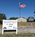 view gallery view galleryNE15.6 km | Camp Gordon Johnston - Carrabelle, Florida, USA. in Wikipedia Entries Camp Gordon Johnston was a World War II US Army amphibious training center, now home to a WWII Museum, & Historic Marker. Located on US 98 / Big Bend Scenic Byway - Coastal trail, at Carrabelle Beach, Northern Florida. posted by: veritas vita location: Florida date approved: 01/19/2018 last visited: 06/10/2020 |
 view gallery view galleryNE15.6 km |  Camp Gordon Johnston - Carrabelle, Florida, USA. Camp Gordon Johnston - Carrabelle, Florida, USA.
in Military Installations Camp Gordon Johnston was a World War II US Army amphibious training base. A Historic Marker & Museum now stand as a monument to the 250,000 Men & Women that served & trained at Camp Gordon Johnston, Carrabelle Beach, Northern Florida. posted by: veritas vita location: Florida date approved: 01/21/2018 last visited: 06/10/2020 |
 view gallery view galleryNE15.6 km |  Camp Gordon Johnston Plaque - Carrabelle, Florida, USA. Camp Gordon Johnston Plaque - Carrabelle, Florida, USA.
in World War II Memorials / Monuments Camp Gordon Johnston was a World War II US Army amphibious training base. A Historic Marker & Museum now stand as a monument to the 250,000 Men & Women that served & trained at Camp Gordon Johnston, Training area, Carrabelle Beach, Northern Florida. posted by: veritas vita location: Florida date approved: 01/20/2018 last visited: 06/10/2020 |
 view gallery view galleryNE15.6 km | Carrabelle Beach WWII D-Day Plaque - Carrabelle, Florida, USA. in World War II Memorials / Monuments Carrabelle Beach was a World War II US Army amphibious training area. A Historic Marker stands as a monument to the Men & Women who served & trained for the Normandy D-Day invasion, on 6/6/1944. The Plaque located at Carrabelle Beach, Florida. posted by: veritas vita location: Florida date approved: 01/21/2018 last visited: 11/19/2020 |
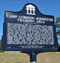
 view gallery view galleryNE15.6 km | Camp Gordon Johnston - Training Area - Carrabelle, Florida, USA. in World War II Sites Camp Gordon Johnston was a World War II US Army amphibious training base. A Historic Marker & Museum now stand as a monument to the 250,000 Men & Women that served & trained at Camp Gordon Johnston, Training area, Carrabelle, Northern Florida. posted by: veritas vita location: Florida date approved: 01/21/2018 last visited: 06/10/2020 |
 view gallery view galleryNE15.6 km | Big Bend Scenic Byway - Camp Gordon Johnston - Carrabelle, Florida, USA. in National Scenic Byways Camp Gordon Johnston was a World War II US Army amphibious training center, now home to a WWII Museum, & Historic Marker. Located on US 98 / Big Bend Scenic Byway - Coastal trail, at Carrabelle Beach, Northern Florida. posted by: veritas vita location: Florida date approved: 01/21/2018 last visited: 06/10/2020 |
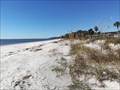
 view gallery view galleryNE15.6 km | Big Bend Scenic Byway - Historic Carrabelle Beach - Carrabelle, Florida, USA. in National Scenic Byways Carrabelle Beach - A curving sugar white sandy beach. Located alongside the Big Bend scenic byway - coastal trail (Hwy 98) - West of the city of Carrabelle, on Florida's forgotten coast. posted by: veritas vita location: Florida date approved: 01/23/2018 last visited: 11/19/2020 |
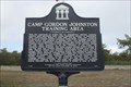 view gallery view galleryNE15.6 km | Camp Gordon Johnston Training Area in Florida Historical Markers Located on US 98/319 in Carabelle Beach. posted by: Markerman62 location: Florida date approved: 01/03/2017 last visited: 06/10/2020 |
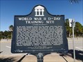
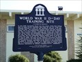 view gallery view galleryNE15.6 km | World War II D-Day Training Site in Florida Historical Markers US Army 4th Infantry Division amphibious training site; last stage of training before shipping out to England prior to the Normandy invasion. posted by: no_angel location: Florida date approved: 01/08/2009 last visited: 11/19/2020 |
 view gallery view galleryNE15.6 km |  Carrabelle Beach - Carrabelle, Florida, USA. Carrabelle Beach - Carrabelle, Florida, USA.
in Beaches Carrabelle Beach - A curving sugar white sandy beach. Located alongside the Big Bend scenic byway - coastal trail (Hwy 98) - West of the city of Carrabelle, on Florida's forgotten coast. posted by: veritas vita location: Florida date approved: 01/22/2018 last visited: 11/19/2020 |
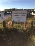 view gallery view galleryNE18.7 km |  Dog Island Ferry, Carrabelle,Florida Dog Island Ferry, Carrabelle,Florida
in Ferries and Ferry Landings Located on Marine St in Carrabelle. posted by: BONSAIRAD location: Florida date approved: 11/17/2020 last visited: never |
|