 view gallery view gallery NW0.2 km NW0.2 km
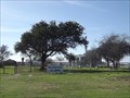
|   Toluca Private Cemetery - Progreso Lakes TX Toluca Private Cemetery - Progreso Lakes TX
in Worldwide Cemeteries This Cemetery is 330 feet west of FM 1015 opposite Toluca Sugar Drive. It's 0.45 miles north of the Progreso International Bridge or 1.25 miles south of the Military Highway (US Hwy 281) in the Progreso Lakes area of Hidalgo County, Texas posted by:  PeterNoG PeterNoG location: Texas date approved: 02/22/2014 last visited: 01/19/2014 |
 view gallery view gallery S0.6 km S0.6 km
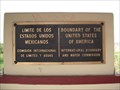
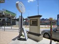
|  Border between United States and Mexico Border between United States and Mexico
in Border Crossings This plaque is located between Progreso Texas and Nuevo Progreso, Mexico. posted by:  linkys linkys location: Texas date approved: 03/06/2008 last visited: 07/17/2015 |
 view gallery view gallery NE0.6 km NE0.6 km
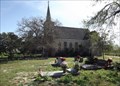
| Toluca Cemetery - Progreso TX in Worldwide Cemeteries This Cemetery is beside Saint Joseph's Church which is at the end of palm tree lined lane off Rancho Toluca Road southeast of Progreso, Texas. posted by: PeterNoG location: Texas date approved: 02/22/2014 last visited: 01/19/2014 |
 view gallery view galleryNE0.6 km |  Toluca Cemetery - Progreso TX Toluca Cemetery - Progreso TX
in Churchyard Cemeteries This Churchyard Cemetery is beside Saint Joseph's Church which is at the end of palm tree lined lane off Rancho Toluca Road southeast of Progreso, Texas. posted by: PeterNoG location: Texas date approved: 02/05/2014 last visited: 01/19/2014 |
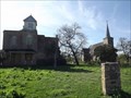 view gallery view galleryNE0.6 km |  Rancho Toluca - Progreso TX Rancho Toluca - Progreso TX
in U.S. National Register of Historic Places Rancho Toluca is a grouping of four buildings that is listed on the National Register of Historic Places. They are at the end of palm tree lined lane off Rancho Toluca Road southeast of Progreso, Texas. posted by: PeterNoG location: Texas date approved: 02/04/2014 last visited: 01/19/2014 |
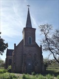 view gallery view galleryNE0.6 km |  Saint Joseph's Church - Progreso TX Saint Joseph's Church - Progreso TX
in This Old Church This Old Church Saint is Saint Joseph's Church which is at the end of palm tree lined lane off Rancho Toluca Road southeast of Progreso, Texas. posted by: PeterNoG location: Texas date approved: 02/04/2014 last visited: 01/19/2014 |
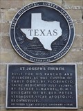 view gallery view galleryNE0.6 km |  Saint Joseph's Church Saint Joseph's Church
in Texas Historical Markers This Texas Historical Marker is mounted on Saint Joseph's Church which is at the end of palm tree lined lane off Rancho Toluca Road southeast of Progreso, Texas. posted by: PeterNoG location: Texas date approved: 02/06/2014 last visited: 01/19/2014 |
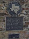 view gallery view galleryNE0.6 km | Don Florencio Saenz Homestead in Texas Historical Markers This Texas Historical Marker is mounted on a short brick wall just inside the fenced area in front of the Don Florencio Saenz Homestead which is at the end of palm tree lined lane off Rancho Toluca Road southeast of Progreso, Texas. posted by: PeterNoG location: Texas date approved: 02/05/2014 last visited: 01/19/2014 |
 view gallery view galleryS0.6 km |  Importation Temporal Permission -- Nuevo Progreso MX Importation Temporal Permission -- Nuevo Progreso MX
in Engrish Signs Thank God we walked across the border, so we didn't have to try and figure out what we were supposed to do. posted by: Benchmark Blasterz location: Tamaulipas, Mexico date approved: 08/18/2015 last visited: 03/07/2018 |
 view gallery view galleryS0.8 km |  Bill Summers -- Nuevo Progreso MX Bill Summers -- Nuevo Progreso MX
in Citizen Memorials A monument near the end of the international bridge in Nuevo Progreso MX commemorates the contribution of Bill Summers to the economic prosperity of the area posted by: Benchmark Blasterz location: Tamaulipas, Mexico date approved: 08/19/2015 last visited: 08/20/2015 |
 view gallery view galleryS0.8 km |  "Highway to Mexico renamed for Chamber head" -- Nuevo Progreso MX "Highway to Mexico renamed for Chamber head" -- Nuevo Progreso MX
in News Article Locations A monument near the end of the highway named for him at Nuevo Progreso MX commemorates the contribution of Bill Summers to the economic prosperity of the area posted by: Benchmark Blasterz location: Tamaulipas, Mexico date approved: 08/19/2015 last visited: 08/19/2015 |
 view gallery view galleryS0.8 km |  Eagle and Snake, Nuevo Progreso, Mexico Eagle and Snake, Nuevo Progreso, Mexico
in Figurative Public Sculpture This 10 foot statue represents the symbol on the Mexican Flag. posted by: linkys location: Mexico date approved: 04/08/2008 last visited: 03/07/2018 |
 view gallery view galleryS1.1 km |  Pharmacy US -- Benito Juarez Blvd at Sonora St., Nuevo Progreso MX Pharmacy US -- Benito Juarez Blvd at Sonora St., Nuevo Progreso MX
in Independent Pharmacies The US pharmacy at Benito Juarez Boulevard and Sonora Street in the busy shopping town of Nuevo Progreso Mexico posted by: Benchmark Blasterz location: Tamaulipas, Mexico date approved: 08/19/2015 last visited: 07/18/2015 |
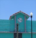 view gallery view galleryS1.1 km |  Town Clock -- Benito Juarez Blvd. at Tamaulipas St, Nuevo Progreso MX Town Clock -- Benito Juarez Blvd. at Tamaulipas St, Nuevo Progreso MX
in Town Clocks This town clock is located in a shopping complex at Benito Juarez Blvd and Tamaulipas Street in Nuevo Progreso MX posted by: Benchmark Blasterz location: Tamaulipas, Mexico date approved: 08/18/2015 last visited: 08/19/2015 |
 view gallery view gallery N2.4 km N2.4 km
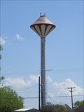
|  Water Tower in Progreso Texas Water Tower in Progreso Texas
in Water Towers This water tower has a red ant hill paint scheme. posted by: linkys location: Texas date approved: 03/07/2008 last visited: 07/17/2015 |
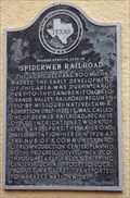 view gallery view galleryN2.7 km | Former Station Site of Spiderweb Railroad in Texas Historical Markers This Texas Historical Marker is on the 'Missouri Pacific Lines' building which is in front of the Progreso Water Tower on FM 1015 in Progreso, Texas. posted by: PeterNoG location: Texas date approved: 01/02/2014 last visited: 01/18/2014 |
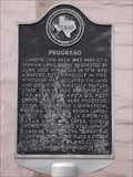 view gallery view galleryN2.9 km | Progreso in Texas Historical Markers This Texas Historical Marker is in front of the Progreso City Hall on FM 1015 at Palm Avenue in Progreso, Texas. posted by: PeterNoG location: Texas date approved: 01/02/2014 last visited: 01/18/2014 |
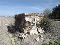
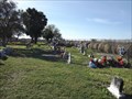 view gallery view galleryNE3.2 km | Relampago Ranch Cemetery - Relampago TX in Worldwide Cemeteries This Cemetery is at the edge of a farm equipment yard, 360 feet south of Rancho Toluca Road, 0.60 miles southwest of the Military Highway (US Hwy 281) in the Relampago Community of Hidalgo County, Texas. posted by: PeterNoG location: Texas date approved: 02/22/2014 last visited: 01/19/2014 |
 view gallery view gallery W3.4 km W3.4 km
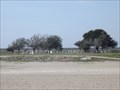
| San Pedro Cemetery - Progreso TX in Worldwide Cemeteries This Cemetery is 0.6 miles south of the junction of the Military Highway (US Hwy 81) and the Old Military Road which is 1.8 miles east of FM 1015 in Progreso, Texas. posted by: PeterNoG location: Texas date approved: 04/14/2014 last visited: 01/19/2014 |
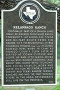 view gallery view galleryNE3.7 km | Relampago Ranch in Texas Historical Markers This ranch was originally part of a Spanish land grant. posted by: JimmyEv location: Texas date approved: 11/15/2007 last visited: 07/17/2015 |
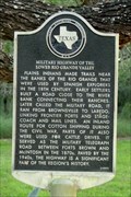 view gallery view galleryNE3.7 km | Military Highway of the Lower Rio Grande Valley in Texas Historical Markers History of the road from Brownsville to Laredo. posted by: JimmyEv location: Texas date approved: 11/15/2007 last visited: 07/17/2015 |
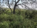 view gallery view galleryNW3.7 km |  Los Parajitos Cemetery - Progreso TX Los Parajitos Cemetery - Progreso TX
in Abandoned Cemeteries This Abandoned Cemetery is 500 feet north of the Military Highway (US Hwy 281) near the Old Military Highway (Santiago Galvan Road), 1.85 miles west of FM 1015 on the west side of Progreso, Texas. posted by: PeterNoG location: Texas date approved: 02/11/2014 last visited: 02/10/2014 |
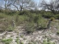 view gallery view galleryNW3.7 km | Los Parajitos Cemetery - Progreso TX in Worldwide Cemeteries This overgrown Cemetery is 500 feet north of the Military Highway (US Hwy 281) near the Old Military Highway (Santiago Galvan Road), 1.85 miles west of FM 1015 on the west side of Progreso, Texas. posted by: PeterNoG location: Texas date approved: 02/22/2014 last visited: 01/19/2014 |
 view gallery view galleryW5 km | Agua Negra Ranch Cemetery - Progreso TX in Worldwide Cemeteries This Cemetery is on a dirt track 0.34 miles south of the Military Highway (US Hwy 281) and 0.3 miles west of FM 88, just west of Progreso, Texas. posted by: PeterNoG location: Texas date approved: 04/14/2014 last visited: 01/19/2014 |
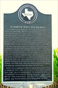 view gallery view gallery E6.3 km E6.3 km
| El Horcon Tract and Rio Rico in Texas Historical Markers Perhaps this is a cautionary tale of what might happen to the two miles of American soil between the Rio Grande and the proposed border fence. posted by: JimmyEv location: Texas date approved: 11/15/2007 last visited: 07/17/2015 |
|