 view gallery view gallery SW7.2 km SW7.2 km
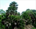
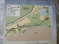
|   Sabal Palm Sanctuary - Brownsville, Texas Sabal Palm Sanctuary - Brownsville, Texas
in Official Local Tourism Attractions This park preserves one of the few remaining tracts of native Sabal Palm Forest. It’s great for birding - you'll probably see a Green Jay - and hiking too. posted by:  JimmyEv JimmyEv location: Texas date approved: 03/20/2008 last visited: 03/07/2018 |
 view gallery view gallery W8 km W8 km
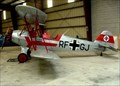
| Rio Grande Valley Wing of the Commemorative Air Force - Brownsville, Texas in Official Local Tourism Attractions This museum, with 11 or so restored aircraft, appeals mainly to hobbyists - others might be a little bored. posted by: JimmyEv location: Texas date approved: 03/20/2008 last visited: never |
 view gallery view gallery NW9.5 km NW9.5 km
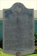
|  Port of Brownsville Port of Brownsville
in Texas Historical Markers The Port of Brownsville was created in 1936 when the federal government dredged a ship channel from Brownsville through Brazos Santiago Pass to the Gulf of Mexico. posted by: JimmyEv location: Texas date approved: 11/13/2007 last visited: 02/01/2014 |
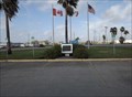 view gallery view galleryNW9.5 km |  F.W."Fritz" Hofmokel - Brownsville TX F.W."Fritz" Hofmokel - Brownsville TX
in Citizen Memorials This Citizen Memorial is front of The Port of Brownsville offices on Capt.Donald L.Foust Road at North Indiana Avenue (FM 511) in Brownsville, Texas. posted by:  PeterNoG PeterNoG location: Texas date approved: 05/15/2014 last visited: 02/01/2014 |
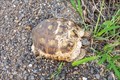 view gallery view gallery NE9.8 km NE9.8 km
|  Texas Tortoise - Brownsville, Texas Texas Tortoise - Brownsville, Texas
in Turtle Crossings This Texas tortoise was crossing Palmito Hill Road east of Brownsville, Texas. posted by: The A-Team location: Texas date approved: 10/08/2023 last visited: never |
 view gallery view galleryNE9.8 km |  Battle of Palmito Hill - Brownsville, Texas Battle of Palmito Hill - Brownsville, Texas
in Battlefields A small interpretive site for the Battle of Palmito Hill, which is considered to be the last battle of the Civil War, is tucked away off the highway. It's located near the north end of Palmito Hill Road near Brownsville, Texas. posted by: The A-Team location: Texas date approved: 09/30/2023 last visited: never |
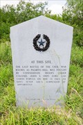 view gallery view galleryNE9.8 km | Last Battle of the Civil War in Texas Historical Markers This marker is tucked away off the highway at a small interpretive site for the Battle of Palmito Hill, which is considered to be the last battle of the Civil War. It's located near the north end of Palmito Hill Road near Brownsville, Texas. posted by: The A-Team location: Texas date approved: 09/30/2023 last visited: never |
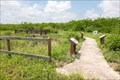
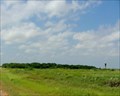
 view gallery view galleryNE10.1 km |  'You are Here' - Palmito Ranch Battlefield - Brownsville TX 'You are Here' - Palmito Ranch Battlefield - Brownsville TX
in 'You Are Here' Maps This 'You Are Here' Map is on Boca Chica Boulevard (Texas Hwy 4) about 4 miles east of Brownsville, Texas. posted by: PeterNoG location: Texas date approved: 05/14/2014 last visited: 05/11/2023 |
 view gallery view galleryNE10.1 km | 'You are Here' - Secluded Beaches, Dunes & Wildlife - Boca Chica TX in 'You Are Here' Maps This 'You Are Here' Map is on Boca Chica Boulevard (Texas Hwy 4) about 4 miles east of Brownsville, Texas and just west of the Boca Chica WMA. posted by: PeterNoG location: Texas date approved: 05/14/2014 last visited: 05/11/2023 |
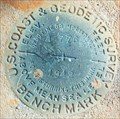 view gallery view galleryNE10.1 km |  A776, AB0063, Hwy 4, Brownsville, TX A776, AB0063, Hwy 4, Brownsville, TX
in U.S. Benchmarks Located near a Historical Marker and a Geocache on Hwy 4. posted by: 8Nuts MotherGoose location: Texas date approved: 07/27/2010 last visited: 02/01/2014 |
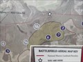
 view gallery view galleryNE10.1 km |  Palmito Ranch Battlefield, Brownsville, Texas Palmito Ranch Battlefield, Brownsville, Texas
in U.S. National Register of Historic Places With severe weather and shifting sands, the tidal flats east of Brownsville were never developed. This has left most of the Palmito Ranch Battlefield, the last land battle of the Civil War, intact with only the course of the Rio Grande changing. posted by: JimmyEv location: Texas date approved: 12/29/2007 last visited: 05/11/2023 |
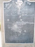 view gallery view galleryNE10.1 km | Battle of Palmito Ranch in Texas Historical Markers The last land battle of the Civil War occurred here. posted by: 8Nuts MotherGoose location: Texas date approved: 04/27/2007 last visited: 05/12/2023 |
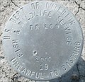 view gallery view galleryNE10.3 km | USDI F&WS TR209 2000 19, TX in U.S. Benchmarks Located along Hwy 4 east of Brownsville, TX posted by: 8Nuts MotherGoose location: Texas date approved: 07/27/2010 last visited: 02/01/2014 |
 view gallery view galleryNW13.2 km |  Kingdom Hall of Jehovah's Witnesses - Old Port Isabel Road - Brownsville TX Kingdom Hall of Jehovah's Witnesses - Old Port Isabel Road - Brownsville TX
in Kingdom Halls of Jehovah's Witnesses This Kingdom Hall of Jehovah's Witnesses is on Old Port Isabel Road, 400 feet north of Coffee Road/Jaime J. Zapata Avenue in Brownsville, Texas. posted by: PeterNoG location: Texas date approved: 02/26/2014 last visited: 01/21/2014 |
 view gallery view galleryNW13.4 km |  Water Tower - Brownsville TX Water Tower - Brownsville TX
in Water Towers This Water Tower is 1000 feet south of Martinal Road, 400 feet east of Old Port Isabel Road in Brownsville, Texas. posted by: PeterNoG location: Texas date approved: 05/07/2014 last visited: 01/21/2014 |
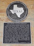 view gallery view galleryW13.5 km | Fort Brown Cavalry Barracks in Texas Historical Markers This Texas Historical Marker is on the northwest side of the Cavalry Barracks on Gorgas Drive at Ringgold Road in Fort Brown (now Texas Southmost College) in Brownsville, Texas. posted by: PeterNoG location: Texas date approved: 01/11/2014 last visited: 07/17/2015 |
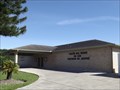
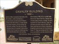 view gallery view galleryW13.5 km |  Cavalry Building - Brownsville TX Cavalry Building - Brownsville TX
in Signs of History This Sign of History is at the southwest corner of the Cavalry Building on Gorgas Drive at Ringgold Road in Fort Brown (now Texas Southmost College) in Brownsville, Texas. posted by: PeterNoG location: Texas date approved: 01/13/2014 last visited: 07/17/2015 |
 view gallery view galleryNW13.7 km |  Rose Lawn Memorial Gardens - Brownsville TX Rose Lawn Memorial Gardens - Brownsville TX
in Worldwide Cemeteries This Cemetery is on Old Port Isabel Road at Robindale Road in Brownsville, Texas. posted by: PeterNoG location: Texas date approved: 04/07/2014 last visited: 01/21/2014 |
 view gallery view galleryW13.8 km | Buena Vista Cemetery - Brownsville TX in Worldwide Cemeteries This very large Cemetery is on McDavitt Boulevard just east of US 77 Expressway in Brownsville, Texas. posted by: PeterNoG location: Texas date approved: 04/07/2014 last visited: 01/21/2014 |
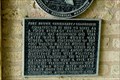 view gallery view galleryW13.8 km | Fort Brown Commissary/Guardhouse in Texas Historical Markers Built a year before the closing of the fort, this building served as a commissary. When the fort was re-activated due to Mexican border disturbances, the building served as the guardhouse and jail. posted by: JimmyEv location: Texas date approved: 11/13/2007 last visited: 07/17/2015 |
 view gallery view galleryW13.8 km | Fort Brown, Texas in Texas Historical Markers This Texas Historical Marker is 130 feet west of the Clubhouse of the Fort Brown Memorial Golf Course on 300 River Levee Road in Brownsville, Texas. posted by: PeterNoG location: Texas date approved: 01/08/2014 last visited: 01/12/2014 |
 view gallery view galleryW13.8 km | Fort Brown, Buildings 85 and 86 in Texas Historical Markers This Texas Historical Marker for Fort Brown Buildings 85 and 86 AKA Morgue and linen storage is on the west end of the "Old Morgue" in Fort Brown, Brownsville, Texas. posted by: PeterNoG location: Texas date approved: 01/12/2014 last visited: 07/17/2015 |
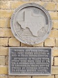
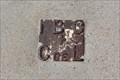 view gallery view galleryW13.8 km | AB0002 B 49 RP 44 IBWC -- Brownsville TX in U.S. Benchmarks A cool joint US International Boundary Commission/MX Comision des Internacional Limites benchmark plate on the campus of Texas Southmost College in Brownsville posted by: Benchmark Blasterz location: Texas date approved: 08/18/2015 last visited: 08/19/2015 |
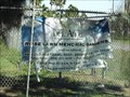
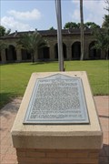 view gallery view galleryW14 km |  124th Cavalry Regiment, TXARNG and USArmy -- Brownsville TX 124th Cavalry Regiment, TXARNG and USArmy -- Brownsville TX
in Specific Veteran Memorials The 124th Cavalry Regiment, of the Texas Army National Guard and US Army was organized in 1929 and deactivated in 1944. During WWII, the 124th fought bravely in the China-Burma Theater, keeping open a vital Allied supply line in Burma. posted by: Benchmark Blasterz location: Texas date approved: 08/18/2015 last visited: 08/19/2015 |
 view gallery view galleryW14 km |  LAST -- Mounted Cavalry Regiment in the USArmy, Brownsville TX LAST -- Mounted Cavalry Regiment in the USArmy, Brownsville TX
in Last of its Kind The 124th Cavalry Regiment, US Army, which was stationed at Fort Brown in Brownsville before being sent to China during WWII is the last mounted cavalry regiment in the Army. posted by: Benchmark Blasterz location: Texas date approved: 08/18/2015 last visited: 08/19/2015 |
|