 view gallery view gallery SE3.9 km SE3.9 km
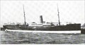
|   ss Waikare ss Waikare
in Shipwrecks On 4th January 1910 the ss Waikare carrying 226 people hit uncharted rocks in Dusky Sound in the Fiords of the South/West Coast of New Zealand. posted by:  StagsRoar StagsRoar location: South Island, New Zealand date approved: 12/15/2005 last visited: never |
 view gallery view gallery S37.3 km S37.3 km
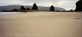
|  Spit Island Spit Island
in Plane Crash Sites On the SouthWest Coast of Fiordland, New Zealand is a small tidal Peninsula/Island that has claimed numerous small plane crashes. posted by: StagsRoar location: South Island, New Zealand date approved: 09/15/2005 last visited: never |
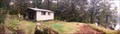
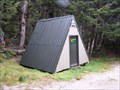
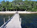
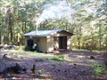
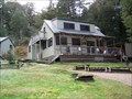
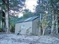 view gallery view gallerySE64.5 km |  Lake Poteriteri Hut Lake Poteriteri Hut
in Remote Backcountry Shelters Located on the shore of Lake Poteriteri in the Fiordland National Park.
Grid reference: Topo50 map sheet CF06, E1148174, N4877002. posted by: StagsRoar location: South Island, New Zealand date approved: 06/03/2012 last visited: never |
 view gallery view gallery E66.5 km E66.5 km
| Monowai Hut in Remote Backcountry Shelters Situated on the shore at the top end of Lake Monowai in Fiordland National Park. posted by: StagsRoar location: South Island, New Zealand date approved: 08/29/2021 last visited: never |
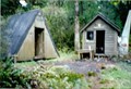
 view gallery view galleryE67.6 km | Borland Bivvy in Remote Backcountry Shelters Located in Southern Fiordland at the start of the Green Lake Track off the Borland/Grebe Valley Roads.
Grid reference: Topo50 map sheet CE07, E1162173, N4919441 posted by: StagsRoar location: South Island, New Zealand date approved: 06/03/2012 last visited: never |
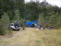 view gallery view galleryE70.3 km |  South Arm - Grebe Valley South Arm - Grebe Valley
in Free Campsites Located on the shore of Lake Manapouri's South Arm beside the outlet of the Grebe River.
Topo50 series map sheet CD07; 1161144/ 4936593 posted by: StagsRoar location: South Island, New Zealand date approved: 06/03/2012 last visited: never |
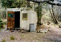
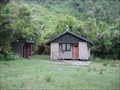 view gallery view gallerySE70.8 km | Teal Bay Hut in Remote Backcountry Shelters Located at southern end of Lake Hauroko in the Fiordland National Park.
Grid reference: Topo50 map sheet CF07, E1158788, N4882727 posted by: StagsRoar location: South Island, New Zealand date approved: 06/02/2012 last visited: never |
 view gallery view galleryE73.2 km |  Oblong Hill Lookout Oblong Hill Lookout
in Scenic Hikes Located at Lake Hauroko in Fiordland posted by: StagsRoar location: South Island, New Zealand date approved: 05/29/2006 last visited: never |
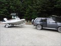
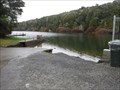
 view gallery view galleryE73.4 km |  Lake Hauroko Boat Ramp Lake Hauroko Boat Ramp
in Boat Ramps Lake Hauroko Boat Ramp and jetty posted by: StagsRoar location: South Island, New Zealand date approved: 08/27/2021 last visited: never |
 view gallery view galleryE74 km | Rogers Inlet Hut in Remote Backcountry Shelters Rogers Inlet Hut is located on Lake Monowai in the Fiordland National Park. posted by: StagsRoar location: South Island, New Zealand date approved: 12/28/2005 last visited: never |
 view gallery view galleryE77.1 km | North Borland Hut in Remote Backcountry Shelters A small Hut located up the North Borland Valley near Lake Monowai in Fiordland. posted by: StagsRoar location: South Island, New Zealand date approved: 12/26/2005 last visited: never |
 view gallery view gallerySE78.9 km | Wairaurahiri Hut in Remote Backcountry Shelters The Wairaurahiri Hut is located in the Waitutu Forest of Southern Fiordland. posted by: StagsRoar location: South Island, New Zealand date approved: 12/28/2005 last visited: never |
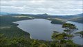
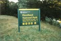 view gallery view galleryE79.3 km |  Fiordland National Park Fiordland National Park
in National Parks of the World Fiordland is the largest national park in New Zealand and one of the largest in the world. It has been recognised as one of the world’s foremost natural landscapes through its inclusion in Te Wahipounamu - South West New Zealand World Heritage Area. posted by: StagsRoar location: South Island, New Zealand date approved: 08/24/2006 last visited: 10/27/2021 |
 view gallery view galleryE79.3 km | Lake Hauroko Camp Ground / Picnic Area in Campgrounds A basic campground located at the entrance of Fiordland National Park 6kms East of Lake Hauroko posted by: StagsRoar location: South Island, New Zealand date approved: 03/25/2006 last visited: never |
 view gallery view galleryE79.5 km | Monowai Boat Ramp in Boat Ramps Located in Fiordlands Lake Monowai posted by: StagsRoar location: South Island, New Zealand date approved: 08/27/2021 last visited: never |
 view gallery view galleryE82.9 km | Hope Arm Hut in Remote Backcountry Shelters Located on the shore of Hope Arm on Lake Manapouri - Fiordland, New Zealand. Grid reference: Topo50 map sheet CE07, E1174169, N4937013 posted by: StagsRoar location: South Island, New Zealand date approved: 06/20/2006 last visited: never |
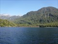 view gallery view galleryE84.2 km |  Calm Bay - West Mere, New Zealand Calm Bay - West Mere, New Zealand
in Public Access Lands Calm Bay is sited on the Northern Shore of Lake Manapouri sraight across from Manapouri Township.
Part of Fiordland National Park in New Zealand. posted by: StagsRoar location: South Island, New Zealand date approved: 09/01/2021 last visited: never |
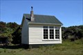 view gallery view gallerySE84.8 km | Port Craig School House in Remote Backcountry Shelters Port Craig School House is a Hut located on the South Coast / Waitutu-Hump Range Track posted by: StagsRoar location: South Island, New Zealand date approved: 01/01/2006 last visited: never |
 view gallery view galleryE88.4 km | Manapouri - Pearl Harbour Ramp in Boat Ramps Lake Manapouri's only public Boat ramp posted by: StagsRoar location: South Island, New Zealand date approved: 08/27/2021 last visited: never |
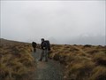 view gallery view gallery NE91.1 km NE91.1 km
|  Kepler Track- New Zealand Kepler Track- New Zealand
in Mountain Summits summit of Mount Luxmore
posted by: deeregal location: New Zealand date approved: 01/28/2008 last visited: 02/01/2011 |
 view gallery view galleryE91.4 km | Moturau Hut in Remote Backcountry Shelters Moturau Hut is part of the Great walks - Kepler Track, Eastern Fiordland, New Zealand.
Grid reference: Topo50 map sheet CD07, E1178760, N4949343 posted by: StagsRoar location: South Island, New Zealand date approved: 06/08/2012 last visited: never |
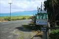 view gallery view gallerySE93.2 km |  Snoopy sleeping on his doghouse — Papatotara, New Zealand Snoopy sleeping on his doghouse — Papatotara, New Zealand
in Peanuts Characters Snoopy's doghouse is also a mailbox in Papatotara. posted by: Dunbar Loop location: South Island, New Zealand date approved: 03/15/2010 last visited: never |
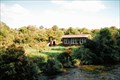
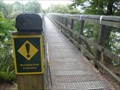 view gallery view galleryE95 km |  Pedestrian Suspension Bridge over Waiau River - Fiordland, New Zealand Pedestrian Suspension Bridge over Waiau River - Fiordland, New Zealand
in Pedestrian Suspension Bridges This ~70 metre suspension bridge crosses the Waiau River and is particularly known for a few things: it's the start (or end) of the Kepler Track (one of NZ's Great Walks), it's the location of a Lord of the Rings scene and it's a great place to fish. posted by:  Trail Blaisers Trail Blaisers location: South Island, New Zealand date approved: 01/06/2014 last visited: never |
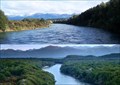 view gallery view galleryE95 km |  Lord of the Rings - Anduin River of Middle Earth. Lord of the Rings - Anduin River of Middle Earth.
in Movie Locations L.O.T.R - The Fellowship of the Ring; The Anduin River - the Great River of Middle Earth. Waiau River - Southland/Fiordland, New Zealand posted by: StagsRoar location: South Island, New Zealand date approved: 06/04/2012 last visited: 02/09/2013 |
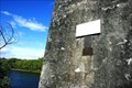 view gallery view galleryE99.1 km |  Joseph Garthwaite — Clifden, New Zealand Joseph Garthwaite — Clifden, New Zealand
in Signs of History The story of Mailboy's Cave and the drowning of Joseph Garthwaite posted by: Dunbar Loop location: South Island, New Zealand date approved: 10/02/2009 last visited: never |
|