
Hope Arm Hut
Posted by:  StagsRoar
S 45° 35.407 E 167° 32.484
58G E 698233 N 4948350
Located on the shore of Hope Arm on Lake Manapouri - Fiordland, New Zealand. Grid reference: Topo50 map sheet CE07, E1174169, N4937013
Waymark Code: WMFAX
Location: South Island, New Zealand
Date Posted: 06/20/2006
Views: 93
This Hut is sited about 3 hrs walk from Pearl Harbour at the Manapouri Township unless you can get there by boat. Your first mission (should you choose to accept it) when doing this track is actually starting - to start you have to cross the Waiau River to it's shore opposite the township. It has been a few years since I have done this but what you need to do is - when you enter the Manapouri Township and you drive around Waiau Street from the lake and just before the Jetties there is a Service/Petrol Station on your left. Enquire in there about Kayaks to Hire to cross the river. Anyone who has been here will know that this is not a wadeable River by any stretch and is probably about 90 - 100 metres from shore to shore. It would even be advised to query the
Department of Conservation
back in Te Anau about Kayak Hire as if the Petrol station no longer hires them then they will know about how to actually get access across to the start of the track.
Once you have yourself and your backpack across Pearl Harbour a climb up the opposite bank to the jetty approx 300 metres across to the left of the Real Journeys office reveals the beginnings of the track you will be taking and you will now tecnically have entered
Fiordland
National Park. The
Tramp
to Hope Arm Hut is 3 hrs from here and is is fairly flat and easy with very little up's and down's. The track follows the western river bank upstream, past the lake outlet, then along the lake shoreline through open bush to the forks (one hour). A signpost here indicates the right branch leading to Hope Arm and the left leading up the ridge on the Circle Track.
The track to Hope Arm starts from the right branch of the fork described above. After a short distance it reaches a moraine spur which descends for 15 minutes until the track branches again, the left branch leads to Back Valley (1 hour) and the right branch to Hope Arm (1.5 hours).
The track to Hope Arm proceeds through a narrow neck of forest, bordered on each side by swamp land.
The track crosses a short section of swamp, across board walk, then proceeds through mixed podocarp and beech forest to the Garnock Burn. After crossing over a wire bridge, continue on to Hope Arm beach. The approx distance walked from Pearl Harbour to Hope Arm Hut is about 9 Kms horizontal walking. The hut is sited at the far end of the beach.
The hut itself is a standard 12 bunk hut with Fireplace/Potbelly - if using the fireplace think "driftwood" from the beach rather than ransacking the surrounding
Forest
.
From the beach in front of the hut - the most obvious of features is The Monument. I did not bother to climb this while I was here and now wish I had but there is seemingly a route up to the top of The Monument and from memory it takes roughly 1 - 1.5 hrs to climb. The Hut book usually has good indicators from people who have previously climbed it as to the time and nature of this climb. The area is also frequented by
Hunters and
Deerstalkers so it pays to be a little conscious of this but doesn't pose as a problem to this walk or the enjoyment of it. As with any of
New Zealands tracks and tramps a
Topographical Map and Compass is also advised despite the good condition and visiblity of this track.
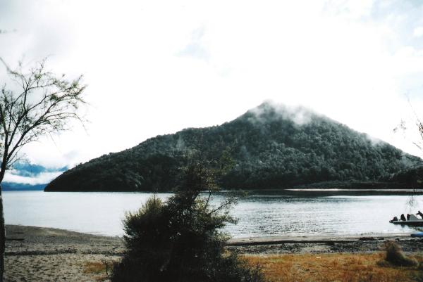
Above pic shows the cloud covered Monument from the beach in front of the hut - looking into Hope Arm of Lake Manapouri.
 Boat Suggested For Access Boat Suggested For Access |
 Hunters often in the area Hunters often in the area |
 Compass & Topographical Map Suggested / Required Compass & Topographical Map Suggested / Required |
 Approx 2-3 Hrs Hiking required Approx 2-3 Hrs Hiking required |
 Wear Insect Repellant! Wear Insect Repellant! |
 Scenic View - Bring A Camera Scenic View - Bring A Camera |
 No Dogs Allowed No Dogs Allowed |