
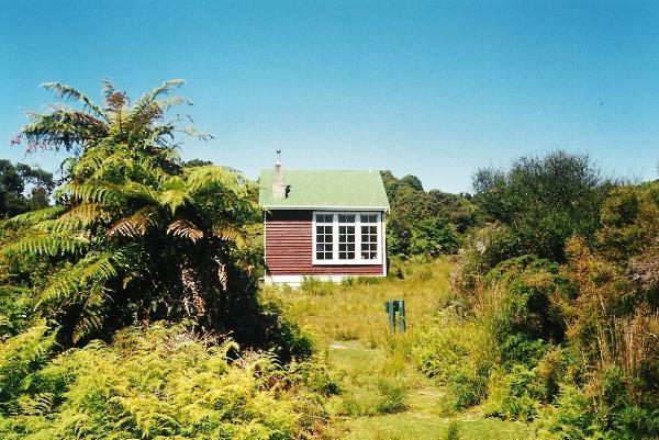
Port Craig School House
Posted by:  StagsRoar
S 46° 13.357 E 167° 21.686
58G E 682114 N 4878507
Port Craig School House is a Hut located on the South Coast / Waitutu-Hump Range Track
Waymark Code: WM5GW
Location: South Island, New Zealand
Date Posted: 01/01/2006
Views: 59
This increasingly popular track is now part of the recently formed
Hump Range walk. Beginning this
walk you will need to Park your vehicle at the Rarakau Farm car park at the approx co-ordinates of: S46*08.848,E167*28.380. This is located along Blue Cliffs beach on Te Waewae Bay south of the Tuatatpere township. The first stretch of walk along this beach can be a pain if you don't have the tides right as if the tide is up a little then the first hour is spent boulder hopping along a stoney beach. If the tide is down a bit then you can stick to the sand on the seaward side of all the rocks. After an hours walk you will hit a small peninsula type landform that has a number of cribs/batches on it and beyond this is the second leg of BlueCliffs beach which is flat sand and takes about 45 mins to walk to the other end. Thereafter begins the walk though beech and native forest sidling around the coast to Port Craig. The whole walk should be about 7 hrs long but you can shave a little time off it by heading off the track in the bush and onto the beach at LOW TIDE ONLY at various marked places. The whole track to
Port Craig is a fairly good one with a few winding bits and some minor ups and downs with a swing bridge early on. Port Craig itself is the site of an old Sawmilling town from the 1920's and was abandoned back at that time with only the school House left remaining which has obviously become a Trampers Hut managed by the Department of Conservation. Since I was here they have built another series of huts about a stones throw through the bush for the Guided Walkers of the Hump Range Track. From the Port Craig Hut it is possible to carry on following the old tram Line through the Waitutu to the Wairaurahiri River &
Hut which I have listed another waymark for. Two hours walk along this track from Port Craig will take you to the
Percy Burn Viaduct which is worth a look. This whole track does see a far bit of foot traffic now-a-days, since the inception of the Hump Range circuit track and possibly a bit more Helicopter traffic ruining the silence as well. I believe there is another hut sited next to the Percy Burn as well and "I think" this to, is only for guided walkers but I haven't seen this hut as has all been built since I was there last. The Port Craig Hut is a serviced Hut and has bunks and Mattresses for 22 people and an open fireplace. You will need to take your own gas cookers. Outside the hut is adequate grassy area for anyone having the inclination to tent it. A walk down to the beach from the hut will take you to the remains of an old pier that was leftover from the hayday of logging here. Relics and remains of buildings and machinary can be found scattered throughout the bush surrounding the hut also. On one trip here I have seen Hectors Dolphins swimming around the old pier as well as Leopard Seals south around from the pier. If you walk along the tram track heading west from the schoolhouse at night time and go to the bit where the track is actually cut into the ground with 6 - 7 ft embankments -- then turn off your torch/flashlight and you may see glow-worms tucked under the bank.
 No Dogs Allowed No Dogs Allowed  Hunting in area - use caution Hunting in area - use caution  Check Tide Times Before Hiking Check Tide Times Before Hiking  Accessible in Winter Accessible in Winter
 Compass & Topographical Map Suggested / Required Compass & Topographical Map Suggested / Required  Weather Permitting Weather Permitting  Historic Site Historic Site  Wear bug repellant! Wear bug repellant! |
| |