 view gallery view gallery S29.8 km S29.8 km
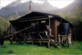
|   McKerrow Island Hut McKerrow Island Hut
in Remote Backcountry Shelters Located on McKerrow Island at the head of Lake McKerrow - South Island of New Zealand posted by:  StagsRoar StagsRoar location: South Island, New Zealand date approved: 12/23/2005 last visited: never |
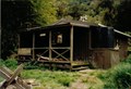 view gallery view galleryS33.6 km | Alabaster Hut in Remote Backcountry Shelters Alabaster hut is part of the Hollyford - Pyke River - Martins Bay walk of Fiordland, New Zealand posted by: StagsRoar location: South Island, New Zealand date approved: 12/24/2005 last visited: never |
 view gallery view gallery SW41.7 km SW41.7 km
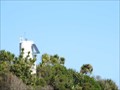
|  St. Anne's Point Lighthouse - Milford Sound - New Zealand St. Anne's Point Lighthouse - Milford Sound - New Zealand
in Coastal Lighthouses Lighthouse at the entrance to Milford Sound on the South Island, New Zealand. posted by:  BruceS BruceS location: South Island, New Zealand date approved: 01/12/2013 last visited: 03/22/2019 |
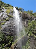
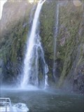 view gallery view galleryS42.5 km |  Stirling Falls - Milford Sound - New Zealand Stirling Falls - Milford Sound - New Zealand
in Waterfalls Permanent waterfall located on the Milford Sound in Fiordland National Park on the South Island, New Zealand. posted by: BruceS location: South Island, New Zealand date approved: 01/08/2013 last visited: 03/18/2024 |
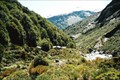
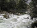
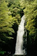 view gallery view galleryS42.6 km | Hidden falls - Hollyford Valley in Waterfalls Tucked away in the rainforest of the Hollyford Valley in the South Island of New Zealand - these falls are certainly worth a look. posted by: StagsRoar location: South Island, New Zealand date approved: 12/06/2005 last visited: never |
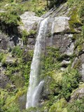 view gallery view galleryS43.5 km | Bridal Veil Falls - Milford Sound - New Zealand in Waterfalls Semi-permanent waterfall accessible by boat tour on Milford Sound in Fiordland National Park, New Zealand. posted by: BruceS location: South Island, New Zealand date approved: 01/08/2013 last visited: 03/18/2024 |
 view gallery view galleryS43.6 km | Fairy Falls - Milford Sound - New Zealand in Waterfalls Waterfall located on Milford Sound in Fiordland National Park in New Zealand. posted by: BruceS location: South Island, New Zealand date approved: 01/08/2013 last visited: 03/18/2024 |
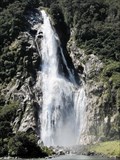 view gallery view galleryS47.3 km | Lady Bowen Falls - Milford Sound - New Zealand in Waterfalls Tallest waterfalls on Milford Sound in Fiordland National Park on South Island, New Zealand. posted by: BruceS location: South Island, New Zealand date approved: 01/08/2013 last visited: 03/18/2024 |
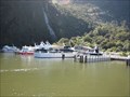 view gallery view galleryS47.5 km |  Milford Sound Scenic Boat Tours - New Zealand Milford Sound Scenic Boat Tours - New Zealand
in Scenic Boat Rides Terminal where several different companies offer scenic boat tours of the Milford Sound. posted by: BruceS location: South Island, New Zealand date approved: 01/08/2013 last visited: 03/18/2024 |
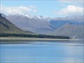 view gallery view galleryS47.5 km |  Fiordland National Park - South Island, New Zealand Fiordland National Park - South Island, New Zealand
in 1000 Places to See Before You Die Fiordland National Park is one of New Zealand’s treasured natural icons and is internationally recognised as part of the wider UNESCO World Heritage site, Te Wahipounamu. posted by: denben location: South Island, New Zealand date approved: 04/02/2023 last visited: 03/18/2024 |
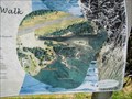 view gallery view galleryS48 km |  Milford Foreshore Walk You Are Here - Milford Sound, New Zealand Milford Foreshore Walk You Are Here - Milford Sound, New Zealand
in 'You Are Here' Maps You are here map for a short loop walk at the end of Milford Sound on the South Island, New Zealand. posted by: BruceS location: South Island, New Zealand date approved: 01/08/2013 last visited: never |
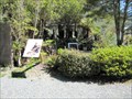
 view gallery view galleryS48 km |  Edge Dwellers - Milford Sound, New Zealand Edge Dwellers - Milford Sound, New Zealand
in Flora and Fauna Information Signs Sign giving information about a small forested area on Milford Sound. posted by: BruceS location: South Island, New Zealand date approved: 01/15/2013 last visited: never |
 view gallery view galleryS48.1 km |  Sutherland Cemetery - Milford Sound, New Zealand Sutherland Cemetery - Milford Sound, New Zealand
in Worldwide Cemeteries Small cemetery in the small community of Milford Sound in South Island, New Zealand. posted by: BruceS location: South Island, New Zealand date approved: 01/09/2013 last visited: never |
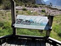
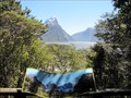 view gallery view galleryS48.1 km |  Milford Sound Overlook - Milford Sound, New Zealand Milford Sound Overlook - Milford Sound, New Zealand
in Scenic Overlooks Overlook above the commercial area in Milford Sound. posted by: BruceS location: South Island, New Zealand date approved: 01/08/2013 last visited: never |
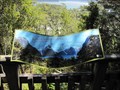 view gallery view galleryS48.1 km |  Milford Sound Overlook Orientation Table - Milford Sound, New Zealand Milford Sound Overlook Orientation Table - Milford Sound, New Zealand
in Orientation Tables Orientation at overlook above the commercial area in Milford Sound. posted by: BruceS location: South Island, New Zealand date approved: 01/08/2013 last visited: never |
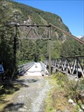
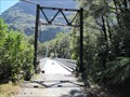 view gallery view galleryS48.1 km |  Tutoko Suspension Bridge - Milford Highway - New Zealand Tutoko Suspension Bridge - Milford Highway - New Zealand
in Suspension Bridges Historic former highway bridge now open to pedestrians along the Milford Highway a few miles east of the Milford Sound. posted by: BruceS location: South Island, New Zealand date approved: 01/08/2013 last visited: 11/25/2016 |
 view gallery view galleryS48.1 km |  Tutoko Suspension Bridge - Milford Highway - New Zealand Tutoko Suspension Bridge - Milford Highway - New Zealand
in Orphaned Bridges Historic former highway bridge now open to pedestrians along the Milford Highway a few miles east of the Milford Sound. posted by: BruceS location: South Island, New Zealand date approved: 01/09/2013 last visited: 11/25/2016 |
 view gallery view gallery SE50.2 km SE50.2 km
| Dart Hut in Remote Backcountry Shelters Dart Hut is sited near the head of the Dart Valley in the shadow of the Forbes Mountains of Mount Aspiring National Park.
Grid reference: Topo50 map sheet CA10, E1246716, N5060574 posted by: StagsRoar location: South Island, New Zealand date approved: 01/03/2006 last visited: never |
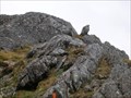 view gallery view galleryS53.3 km |  Conical Hill, Routeburn Track Conical Hill, Routeburn Track
in Mountain Summits Conical Hill is a steep side trip off the Routeburn Track. posted by: Zorkin Queen & The Fox location: South Island, New Zealand date approved: 11/21/2007 last visited: 12/07/2005 |
 view gallery view gallery E53.6 km E53.6 km
| Scotts Rock Bivvy in Remote Backcountry Shelters Scotts Rock Bivvy sits at the Head of the Matukituki Valley under the shadow of Mount Aspiring. posted by: StagsRoar location: South Island, New Zealand date approved: 12/25/2005 last visited: never |
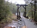
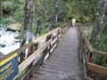 view gallery view galleryS53.9 km |  Unknown Stream and Waterfalls Bridge - Routeburn Track - New Zealand Unknown Stream and Waterfalls Bridge - Routeburn Track - New Zealand
in Hiking Path Footbridges Bridge across an unknown stream on the Routeburn Track in New Zealand. posted by: BruceS location: South Island, New Zealand date approved: 01/06/2013 last visited: never |
 view gallery view galleryS54.2 km | Routeburn River Swing Bridge - Routeburn Track - New Zealand in Hiking Path Footbridges Swing bridge over the Routeburn River on the Routeburn Track on the South Island in New Zealand. posted by: BruceS location: South Island, New Zealand date approved: 01/06/2013 last visited: never |
 view gallery view galleryS54.2 km |  Routeburn River Swing Bridge - Routeburn Track - New Zealand Routeburn River Swing Bridge - Routeburn Track - New Zealand
in Pedestrian Suspension Bridges Swing bridge over the Routeburn River on the Routeburn Track on the South Island in New Zealand. posted by: BruceS location: South Island, New Zealand date approved: 01/06/2013 last visited: never |
 view gallery view galleryS54.2 km | Sugarloaf Stream Swing Bridge - Routeburn Track - New Zealand in Pedestrian Suspension Bridges Swing bridge over stream along the Routeburn Track in New Zealand. posted by: BruceS location: South Island, New Zealand date approved: 01/06/2013 last visited: never |
 view gallery view galleryS54.2 km | Sugarloaf Stream Swing Bridge - Routeburn Track - New Zealand in Hiking Path Footbridges Swing bridge over stream along the Routeburn Track in New Zealand. posted by: BruceS location: South Island, New Zealand date approved: 01/06/2013 last visited: never |
|