 view gallery view gallery NE34.9 km NE34.9 km
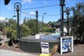
|   The Hanmer Springs Gasometer, The Hanmer Springs Gasometer,
in Gasometers This gasometer was commisioned in 1898 and supplied gas to the sanitorium. It was decommisioned in 1940 when the town was connected to the national grid. posted by:  greysman greysman location: South Island, New Zealand date approved: 03/27/2011 last visited: 03/07/2013 |
 view gallery view gallery E68.4 km E68.4 km
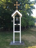
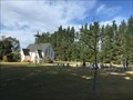
|  St Anthonys Catholic Church - Cheviot, New Zealand St Anthonys Catholic Church - Cheviot, New Zealand
in Bell Towers The picturesque St Anthony's Catholic Church, located on a scenic just on the edge of Cheviot township posted by: waiiti20 location: South Island, New Zealand date approved: 02/19/2016 last visited: 02/19/2016 |
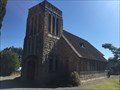 view gallery view galleryE69.2 km |  Knox Presbyterian Church - Cheviot, New Zealand Knox Presbyterian Church - Cheviot, New Zealand
in Cobblestone Buildings This stone church is built with stones gathered from near the Hurunui River. It was opened in September 1953. posted by: waiiti20 location: South Island, New Zealand date approved: 02/22/2016 last visited: 02/21/2016 |
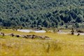
 view gallery view galleryE69.4 km |  Cheviot Hills Reserve - Cheviot, Canterbury, New Zealand Cheviot Hills Reserve - Cheviot, Canterbury, New Zealand
in Municipal Parks and Plazas Cheviot Hills Reserve is managed by Hurunui District Council and is a fine place to walk and geocache (and now waymark!). There are some very large trees. Sheep graze throughout the woodlands. posted by: Trail Blaisers location: South Island, New Zealand date approved: 01/02/2014 last visited: never |
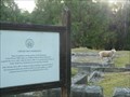 view gallery view galleryE69.8 km |  Cheviot Hills Homestead - Cheviot, Canterbury, New Zealand Cheviot Hills Homestead - Cheviot, Canterbury, New Zealand
in Preserved Architectural Remnants and Ruins Cheviot Hills Homestead (locally known as Mansion House) burnt down in 1936, leaving only the sandstone foundation that you can see today. posted by: Trail Blaisers location: South Island, New Zealand date approved: 01/18/2014 last visited: never |
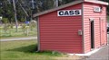 view gallery view gallery SW69.8 km SW69.8 km
|  Cass - New Zealand Cass - New Zealand
in Train Stations/Depots Small railwaystation on the trackline Christchurch - Graymouth. posted by: superstein location: South Island, New Zealand date approved: 03/28/2015 last visited: 09/06/2015 |
 view gallery view gallery W74.7 km W74.7 km
| Otira, New Zealand in Train Stations/Depots Otira train station is a part of the Tranz Alpine track and is 'Otira' railway tunnel. posted by: superstein location: South Island, New Zealand date approved: 03/16/2015 last visited: never |
 view gallery view galleryW74.7 km |  Otira, New Zealand, 1239 feet Otira, New Zealand, 1239 feet
in Elevation Signs A elevation sign on Otira railwaystation. posted by: superstein location: South Island, New Zealand date approved: 03/15/2015 last visited: never |
 view gallery view galleryW77.6 km |  Arthur Dudley Dobson - Arthers Pass - New Sealand Arthur Dudley Dobson - Arthers Pass - New Sealand
in Obelisks obelisks in memory of Athhur Dudley Dobson. posted by: superstein location: South Island, New Zealand date approved: 02/28/2021 last visited: never |
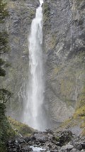 view gallery view gallerySW78.2 km |  devil's punchbowl waterfall, New zealand devil's punchbowl waterfall, New zealand
in Waterfalls One of the most impressive waterfalls in New Zealand, Devils Punchbowl Falls is located in the heart of Arthur's Pass National Park posted by: superstein location: South Island, New Zealand date approved: 01/12/2015 last visited: 11/20/2016 |
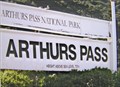
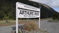 view gallery view gallerySW78.5 km | Arthur's Pass - New Zealand in Train Stations/Depots Arthur's Pass railway station is a part of the 'TranzAlpine' track between Christchurch and Greymouth posted by: superstein location: South Island, New Zealand date approved: 05/07/2015 last visited: 11/19/2016 |
 view gallery view gallerySW78.5 km | Arthurs Pass Station - 737metres. New Zealand. in Elevation Signs An elevation sign at the Arthurs Pass Railway Station platform, 737 metres above sealevel. posted by: Punga and Paua location: South Island, New Zealand date approved: 05/07/2009 last visited: 11/19/2016 |
  N81.3 km N81.3 km
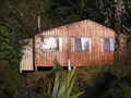
|  John Tait Hut - Travers Valley _ Nelson Lakes National Park John Tait Hut - Travers Valley _ Nelson Lakes National Park
in Remote Backcountry Shelters A serviced DoC Hut in the Travers Valley posted by: madiecacher location: South Island, New Zealand date approved: 07/28/2008 last visited: never |
 view gallery view gallerySW85.5 km | Springfield - New Zealand in Train Stations/Depots Springfield Station is a trainstation who was build in 1965. posted by: superstein location: South Island, New Zealand date approved: 02/17/2021 last visited: never |
 view gallery view galleryN86.1 km | D'urville Hut in Remote Backcountry Shelters Sited at the head of Lake Rotoroa in the Nelson Lakes Park posted by:  StagsRoar StagsRoar location: South Island, New Zealand date approved: 12/28/2005 last visited: never |
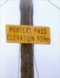 view gallery view gallerySW90.6 km | Porters Pass - 939m. South Is. New Zealand. in Elevation Signs An elevation sign on a telegraph pole at Porters Pass. posted by: Punga and Paua location: South Island, New Zealand date approved: 10/07/2009 last visited: 10/08/2009 |
 view gallery view gallery S91.7 km S91.7 km
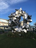
|  Cumulus Gate Pavilion For Richard Pearse - Christchurch, New Zealand Cumulus Gate Pavilion For Richard Pearse - Christchurch, New Zealand
in Abstract Public Sculptures A quirky construction just as you enter or leave Christchurch Airport posted by: waiiti20 location: New Zealand date approved: 07/18/2015 last visited: 06/02/2016 |
 view gallery view galleryS91.7 km |  International Antarctic Centre. Christchurch. New Zealand. International Antarctic Centre. Christchurch. New Zealand.
in Antarctic Points of Interest The Antarctic Attraction at the International Antarctic Centre is Christchurch’s leading visitor attraction. Christchurch has been the gateway to Antarctica for well over a century. posted by: Punga and Paua location: South Island, New Zealand date approved: 08/07/2008 last visited: 10/23/2011 |
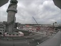 view gallery view galleryS91.7 km |  Tallest air traffic control tower in New Zealand. Christchurch. New Zealand. Tallest air traffic control tower in New Zealand. Christchurch. New Zealand.
in Superlatives Prime Minister John Key will officially open New Zealand's tallest airport control tower in Christchurch today, 10th September, 2009. posted by: Punga and Paua location: North Island, New Zealand date approved: 09/09/2009 last visited: 04/19/2018 |
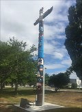 view gallery view galleryS92.1 km |  The Totem Pole of Friendship - Christchurch, New Zealand The Totem Pole of Friendship - Christchurch, New Zealand
in Gifts from Other Countries This pole was a gift from the people of Oregon, USA, to the people of Christchurch, New Zealand, in appreciation of hospitality given to personnel of Operation Deep Freeze. posted by: waiiti20 location: South Island, New Zealand date approved: 12/16/2016 last visited: 10/26/2016 |
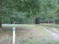
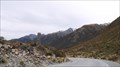
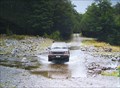 view gallery view galleryNE92.5 km |  Six Mile Creek. Rainbow Valley. South Is. New Zealand. Six Mile Creek. Rainbow Valley. South Is. New Zealand.
in Bridgeless Water Crossings Six Mile Creek crosses the wilderness Rainbow Road linking St Arnaud and Hanmer Springs. There is a rough ford where the road crosses the stream just past the Rainbow Ski Area turn-off, 26 km from the Wairau Valley road end. posted by: Punga and Paua location: South Island, New Zealand date approved: 04/30/2009 last visited: 09/05/2009 |
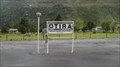
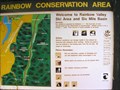 view gallery view galleryNE92.5 km |  You Are Here at Rainbow Conservation Area. South Is. New Zealand. You Are Here at Rainbow Conservation Area. South Is. New Zealand.
in 'You Are Here' Maps "You Are Here" at the base of the Rainbow Ski Field Road in the Six Mile Basin at Rainbow Conservation Area. posted by: Punga and Paua location: South Island, New Zealand date approved: 04/30/2009 last visited: 04/30/2009 |
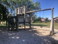 view gallery view galleryS92.7 km |  Nepal Reserve Playground - Christchurch, New Zealand Nepal Reserve Playground - Christchurch, New Zealand
in Public Playgrounds A compact wooden playground in the quiet but large Nepal Reserve. posted by: nico_notfrench location: South Island, New Zealand date approved: 01/12/2024 last visited: never |
 view gallery view galleryN93.2 km | Lake Head Hut - Travers Valley in Remote Backcountry Shelters Located at the head of Lake Rotoiti at the outlet of the Travers River posted by: StagsRoar location: South Island, New Zealand date approved: 12/27/2005 last visited: never |
 view gallery view galleryS95.8 km |  St Pauls Anglican Church - West Melton, New Zealand St Pauls Anglican Church - West Melton, New Zealand
in Churchyard Cemeteries A beautiful historic country church on the outskirts of Christchurch posted by: waiiti20 location: South Island, New Zealand date approved: 06/18/2016 last visited: 06/11/2016 |
|