 view gallery view gallery E1.6 km E1.6 km
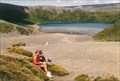
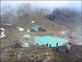
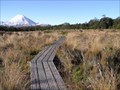
|   Tama Lakes Lookout. Tongariro National Park. North Is. New Zealand. Tama Lakes Lookout. Tongariro National Park. North Is. New Zealand.
in Scenic Overlooks A 5-6 hr return walk across undulating tussock land will take you to this stunning viewpoint of the Lower Tama Lake on the Tama Lakes track at the saddle between Mt Ruapehu and Mt Ngauruhoe. posted by:  Punga and Paua Punga and Paua location: North Island, New Zealand date approved: 07/29/2020 last visited: 07/29/2020 |
 view gallery view gallery W1.6 km W1.6 km
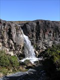
| Taranaki Falls View. Tongariro National Park. New Zealand. in Scenic Overlooks A stunning viewpoint of Taranaki Falls, a waterfall cascading over an old lava flow, in the Tongariro National Park. posted by: Punga and Paua location: North Island, New Zealand date approved: 10/07/2020 last visited: 10/07/2020 |
 view gallery view galleryW1.6 km |  Taranaki Falls. Tongariro National Park. New Zealand. Taranaki Falls. Tongariro National Park. New Zealand.
in Waterfalls Taranaki Falls is a stunning waterfall cascading over an old lava flow in the Tongariro National Park. posted by: Punga and Paua location: North Island, New Zealand date approved: 04/29/2014 last visited: 11/10/2009 |
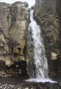 view gallery view galleryW1.6 km |  STAND Under A Waterfall (fully clothed and dry). STAND Under A Waterfall (fully clothed and dry).
in Photo Goals To successfully complete this challenge you need to be able to walk behind the falling water to STAND UNDER a waterfall and have a photo taken of yourself (fully clothed and dry)underneath and behind the curtain of falling water. posted by: Punga and Paua location: North Island, New Zealand date approved: 05/06/2009 last visited: 04/16/2023 |
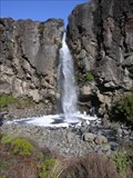 view gallery view galleryW1.6 km |  Falls over a Lava Flow. Tongariro National Park. New Zealand. Falls over a Lava Flow. Tongariro National Park. New Zealand.
in Places of Geologic Significance The Taranaki Falls tumble over the edge of a large lava flow that erupted from the volcano of Mt Ruapehu 15,000 years ago. posted by: Punga and Paua location: North Island, New Zealand date approved: 09/13/2009 last visited: 12/01/2010 |
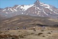
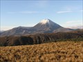
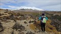 view gallery view galleryW3.2 km | Mt Ruapehu Viewpoint. Tongariro National Park. North Is, New Zealand. in Scenic Overlooks Another stunning viewpoint to admire the volcanoes of Mts Ruapehu and Ngauruhoe in the Tongariro National Park, Central North Island of New Zealand. posted by: Punga and Paua location: North Island, New Zealand date approved: 09/30/2023 last visited: 09/30/2023 |
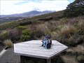 view gallery view galleryW3.4 km | Ridge Track Lookout. Mt Ruapehu. North Is. New Zealand. in Scenic Overlooks A seating platform on the Ridge Track up the lower slopes of Mt Ruapehu provides a panoramic view over The Chateau and around the western side of Tongariro National Park. posted by: Punga and Paua location: North Island, New Zealand date approved: 02/01/2017 last visited: 02/02/2017 |
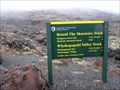 view gallery view galleryW3.5 km |  Round The Mountain Track. Tongariro National Park. NEW ZEALAND. Round The Mountain Track. Tongariro National Park. NEW ZEALAND.
in Long Distance Hiking Trails The Round the Mountain Track is a 4-5 day walk through the diverse landscapes and vegetation on Mt Ruapehu's flanks - from the Rangipo Desert on eastern slopes to the beech and podocarp rainforests of the southern and western aspects. posted by: Punga and Paua location: North Island, New Zealand date approved: 03/11/2009 last visited: 12/01/2010 |
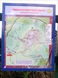 view gallery view galleryW3.5 km |  Tongariro Northern Circuit. Mt Ruapehu. New Zealand. Tongariro Northern Circuit. Mt Ruapehu. New Zealand.
in 'You Are Here' Maps YOU ARE HERE beside the Tongariro Northern Circuit Track information board at the start of the track, at Whakapapa Village on Mt Ruapehu. posted by: Punga and Paua location: North Island, New Zealand date approved: 06/09/2008 last visited: 05/29/2008 |
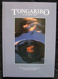 view gallery view galleryW3.7 km |  Tongariro - A Sacred Gift. Tongariro National Park. New Zealand. Tongariro - A Sacred Gift. Tongariro National Park. New Zealand.
in There's a Book About It "Tongariro - A Sacred Gift" is the result of an intensive study of New Zealand's first national park. The book is about the volcanic origins, human history, flora and fauna and problems associated with conservation and exploitation of the area. posted by: Punga and Paua location: North Island, New Zealand date approved: 04/03/2009 last visited: 01/11/2018 |
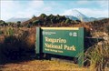
 view gallery view galleryW3.7 km |  Tongariro National Park. North Island. New Zealand. Tongariro National Park. North Island. New Zealand.
in National Parks of the World Established in 1887, Tongariro was the first national park in New Zealand and the fourth in the world. It is also a dual World Heritage area. Please make a genuine visit....Don't just drive by! posted by: Punga and Paua location: North Island, New Zealand date approved: 08/05/2008 last visited: 11/08/2016 |
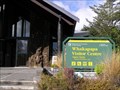
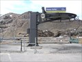
 view gallery view galleryW3.7 km |  Whakapapa Visitor Centre. Mt Ruapehu. New Zealand. Whakapapa Visitor Centre. Mt Ruapehu. New Zealand.
in Tourist Information Centers - Visitor Centers The Whakapapa Visitor Centre is situated at the main gateway to Tongariro National Park, New Zealand’s first national park and presently attracting in excess of one million visitors per annum. posted by: Punga and Paua location: North Island, New Zealand date approved: 06/12/2008 last visited: 11/18/2008 |
 view gallery view galleryW3.7 km |  Tongariro National Park. North Is. New Zealand. Tongariro National Park. North Is. New Zealand.
in World Heritage Sites Established in 1887, Tongariro was the first national park in New Zealand and the fourth in the world. It is also a dual World Heritage area, a status which recognises the park's important Maori cultural and spiritual associations as well as its outstanding volcanic features. posted by: Punga and Paua location: New Zealand date approved: 08/28/2008 last visited: 01/11/2018 |
 view gallery view galleryW3.7 km |  Dept. of Conservation Whakapapa Visitor Centre. Whakapapa. New Zealand. Dept. of Conservation Whakapapa Visitor Centre. Whakapapa. New Zealand.
in Ranger Stations Situated in the village of Whakapapa at the base of Mt Ruapehu in the Tongariro National Park, this visitor centre is run by the Department of Conservation, who are our New Zealand "Rangers" of NZ's National Parks and Reserves. posted by: Punga and Paua location: North Island, New Zealand date approved: 03/20/2009 last visited: 12/01/2010 |
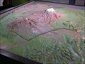 view gallery view galleryW3.7 km |  The Volcanoes, Tongariro National Park. New Zealand. The Volcanoes, Tongariro National Park. New Zealand.
in 3D Map Models of Our World and Beyond A landscape model of Tongariro National Park featuring the volcanoes of Mt Tongariro, Ngauruhoe and Ruapehu, is situated inside the Visitor Centre at the foot of Mt Ruapehu in Tongariro National Park. posted by: Punga and Paua location: North Island, New Zealand date approved: 12/11/2012 last visited: 12/11/2012 |
 view gallery view galleryW3.9 km |  "One run - and 700 reasons" Tussock Traverse, Tongariro National Park, New Zealand. "One run - and 700 reasons" Tussock Traverse, Tongariro National Park, New Zealand.
in News Article Locations A news article in the New Zealand Herald written about some of the 700 runners and their reasons for taking part in the annual Tussock Traverse 26km run/walk across the centre of the Tongariro National Park. posted by: Punga and Paua location: North Island, New Zealand date approved: 04/03/2013 last visited: 04/03/2013 |
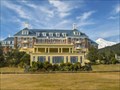 view gallery view galleryW3.9 km |  Chateau Tongariro. Central Plateau. New Zealand. Chateau Tongariro. Central Plateau. New Zealand.
in Antique Hotels Chateau Tongariro is a New Zealand hotel and resort complex.
It is located close to Whakapapa skifield on the slopes of Mount Ruapehu, and is close to the volcanic peaks of Mount Tongariro and Mount Ngauruhoe, within the boundaries of Tongariro National Park, New Zealand's oldest.
Now officially titled Bayview Chateau Tongariro, the building was completed in 1929 and, despite extensive refurbishment, still retains much of the style of the pre-Depression era. posted by: Punga and Paua location: New Zealand date approved: 04/27/2008 last visited: 03/21/2015 |
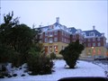 view gallery view galleryW3.9 km |  The Chateau Tongariro - World War II - Whakapapa. New Zealand. The Chateau Tongariro - World War II - Whakapapa. New Zealand.
in Field Hospitals The Chateau in Tongariro National Park was used as an asylum hospital and recuperation centre for Returned Servicemen during World War II. posted by: Punga and Paua location: North Island, New Zealand date approved: 11/09/2010 last visited: 03/21/2015 |
 view gallery view galleryW4.5 km |  Boardwalk on Silica Springs Track, Mt Ruapehu. North Is. New Zealand. Boardwalk on Silica Springs Track, Mt Ruapehu. North Is. New Zealand.
in Non-Coastal Boardwalks This boardwalk crosses alpine bogs and marshes on the Silica Springs Track on Mt Ruapehu in the Tongariro National Park. posted by: Punga and Paua location: North Island, New Zealand date approved: 04/04/2019 last visited: 04/05/2019 |
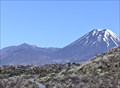
 view gallery view galleryW4.5 km | Volcano Views. Tongariro National Park. North Island. New Zealand. in Scenic Overlooks These stunning views of the volcanoes in the Tongariro National Park can be enjoyed from the walking track to Silica Springs. posted by: Punga and Paua location: North Island, New Zealand date approved: 09/29/2019 last visited: 09/29/2019 |
 view gallery view gallery SW4.5 km SW4.5 km
|  Mt Doom - Lord of The Rings. New Zealand. Mt Doom - Lord of The Rings. New Zealand.
in Movie Locations The Lord of the Rings location of Mt Doom was filmed on the slopes of Mt Ruapehu and Ngauruhoe in the Tongariro National Park, North Island New Zealand. posted by: Punga and Paua location: New Zealand date approved: 08/26/2008 last visited: 01/11/2018 |
 view gallery view gallerySW4.7 km | Upper Silica Rapids Track Lookout. Mt Ruapehu. North Is. New Zealand. in Scenic Overlooks A stunning view of the mountains of Tongariro National Park can be seen from these steps along the upper Silica Rapids Track across the tussock slopes of Mt.Ruapehu. posted by: Punga and Paua location: North Island, New Zealand date approved: 02/02/2017 last visited: 02/02/2017 |
 view gallery view gallerySW4.7 km |  Centennial Chair - 1630m - Ruapehu. New Zealand. Centennial Chair - 1630m - Ruapehu. New Zealand.
in Elevation Signs At the Top Of The Bruce on Mt Ruapehu, the sign at the base of the Centennial Chairlift on Whakapapa Skifield shows an altitude of 1630m. posted by: Punga and Paua location: North Island, New Zealand date approved: 11/15/2010 last visited: 11/15/2010 |
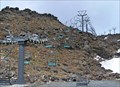 view gallery view gallerySW4.7 km |  Centennial Chairlift. Ruapehu. New Zealand. Centennial Chairlift. Ruapehu. New Zealand.
in Aerial Lifts The Centennial Chairlift carries skiers and supplies from the Top of the Bruce up Mt Ruapehu to the Hut Flat level, on a double seater that takes 8 minutes. posted by: Punga and Paua location: North Island, New Zealand date approved: 08/08/2011 last visited: 01/11/2018 |
 view gallery view gallerySW4.7 km | Happy Valley - 1630m - Ruapehu. New Zealand. in Elevation Signs From the Whakapapa Skifield Base at the top of the Bruce Road, a free chairlift ride from an altitude of 1630m drops down 19m into Happy Valley. posted by: Punga and Paua location: North Island, New Zealand date approved: 11/15/2010 last visited: 06/07/2012 |
|