 view gallery view gallery N10.1 km N10.1 km
|   Kareela, Thunderbolts Way, NSW Kareela, Thunderbolts Way, NSW
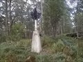
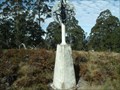
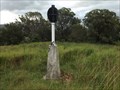
in Australian Trig Points This concrete pedestal trig is not far from the Thunderbolts Way, but is not visible from 'anywhere'.
Official Code: TS5668 posted by:  Grahame Cookie Grahame Cookie location: New South Wales, Australia date approved: 05/24/2015 last visited: never |
 view gallery view gallery SE23 km SE23 km
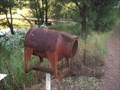
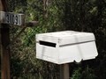
|  Cow Letterbox - Tibbuc, NSW, Australia Cow Letterbox - Tibbuc, NSW, Australia
in Themed Homemade Mailboxes This Homemade Themed Letterbox is right beside Thunderbolts Way, north of Barrington. posted by: Grahame Cookie location: New South Wales, Australia date approved: 02/15/2019 last visited: never |
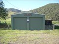
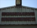 view gallery view gallerySE23.7 km |  Tibbuc Volunteer Bush Fire Brigade Tibbuc Volunteer Bush Fire Brigade
in Firehouses This is the volunteer Fire Brigade for the rural community of Tibbuc. posted by: Grahame Cookie location: New South Wales, Australia date approved: 02/10/2019 last visited: never |
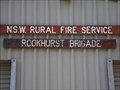 view gallery view gallerySE27.2 km | Rookhurst Brigade in Firehouses This is the local volunteer Fire Brigade for the rural community of Rookhurst. posted by: Grahame Cookie location: New South Wales, Australia date approved: 02/10/2019 last visited: never |
 view gallery view gallerySE33.8 km | Knorrit Flat Riverside Retreat, Caffreys Flat, NSW, Australia in Themed Homemade Mailboxes This caravan shaped letterbox is very appropriate for the Knorrit Flat Riverside Retreat, at 3109 Nowendoc Rd, Caffreys Flat, NSW, 2424. posted by: Grahame Cookie location: New South Wales, Australia date approved: 12/03/2015 last visited: never |
 view gallery view gallery NW35.1 km NW35.1 km
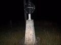
| Omeo trig, Mernot/Niangala, NSW in Australian Trig Points Between Nowendoc and Nundle, on the Great Dividing Range in northern new South Wales is another concrete pedestal trig. Official Code: TS6073; Elevation: 1350 metres posted by: Grahame Cookie location: New South Wales, Australia date approved: 11/25/2016 last visited: never |
 view gallery view gallerySE37.2 km | Kia Ora, Barrington, NSW in Australian Trig Points At a nice lookout over the Gloucester and Barrington regions is this concrete pedestal trig. Official Code: TS10431 posted by: Grahame Cookie location: New South Wales, Australia date approved: 01/02/2016 last visited: never |
 view gallery view gallery E37.8 km E37.8 km
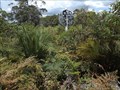
| Pinanpinga TP, Knodingbul Forest, NSW in Australian Trig Points This is a concrete pedestal trig, with plastic post, and what were black semi-circular vanes (but basically all the paint has pealed off); no name plate. A 4-Wheel would be an advantage. Otherwise a bit of a walk needed. Official Code: TS6032 posted by: Grahame Cookie location: New South Wales, Australia date approved: 11/16/2015 last visited: never |
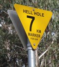 view gallery view galleryN38.5 km |  Hell Hole, 7km Marker, Riamukka Area, NSW, Australia Hell Hole, 7km Marker, Riamukka Area, NSW, Australia
in Man-made Devilish Locations On the WINDY road to "Hell Hole" up on the "Great Dividing Range" of New South Wales, there are signs each kilometre reminding the driver to use their UHF radio, and gives a reference for them to use in warning the logging trucks. posted by: Grahame Cookie location: New South Wales, Australia date approved: 07/14/2015 last visited: never |
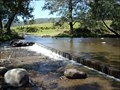
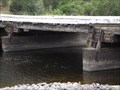 view gallery view gallerySE38.6 km |  Manning River, "Tiri Creek", NSW, Australia Manning River, "Tiri Creek", NSW, Australia
in Plank Roads Situated over the delightful Manning River at Tiri Creek is this low level, log beam, multi-span wooden bridge. Local hard wood is used for the spanning logs (unsawn) as well as the surface boards. posted by: Grahame Cookie location: New South Wales, Australia date approved: 11/26/2015 last visited: never |
 view gallery view galleryNW38.9 km | Flags Trig near Nowendoc State Forest NSW in Australian Trig Points Flags Trig is on Black Sugarloaf Mountain at 1400 m elevation. Official Code: TS6069 posted by:  John1041 John1041 location: New South Wales, Australia date approved: 11/11/2018 last visited: 12/17/2018 |
 view gallery view galleryN40.2 km | Grundy GS, Riamukka Area/Walcha, NSW in Australian Trig Points Set right near the Grundy fire look out tower is this concrete pedestal trig, in the Riamukka Area. Official Code: TS5648; Elevation of 1463 metres. posted by: Grahame Cookie location: New South Wales, Australia date approved: 10/25/2016 last visited: never |
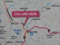 view gallery view gallerySE40.7 km |  You Are Here - Gloucester, NSW, Australia You Are Here - Gloucester, NSW, Australia
in 'You Are Here' Maps This district map is at the turn off to The Bucketts Scenic Walk. posted by: Grahame Cookie location: New South Wales, Australia date approved: 04/21/2024 last visited: never |
 view gallery view gallery S40.7 km S40.7 km
| N.S.W. Rural Fire Service, Gloucester River Brigade in Firehouses N.S.W. Rural Fire Service, Gloucester River Brigade, Gloucester Tops, NSW, Australia posted by: Pensive Travellers location: New South Wales, Australia date approved: 01/02/2009 last visited: 12/29/2015 |
 view gallery view gallerySE40.9 km | Henderson, Gloucester, NSW in Australian Trig Points This is an 'intact' concrete pedestal trig, out on some open farmland, west of The Bucketts Way. Official Code: TS10432 posted by: Grahame Cookie location: New South Wales, Australia date approved: 05/31/2017 last visited: never |
 view gallery view gallerySE41 km | Gloucester trig, NSW in Australian Trig Points Situated on "the Bucketts" west of Gloucester this trig requires quite a walk to get to, and then a steep scramble. Don't under estimate the difficulty of access. Height measured: 550m. * Terrain rating 4½ * Official Code: TS5905 posted by: Grahame Cookie location: New South Wales, Australia date approved: 07/29/2015 last visited: never |
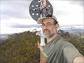
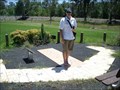 view gallery view gallerySE41 km |  The Human Sundial, Gloucester, NSW, Australia The Human Sundial, Gloucester, NSW, Australia
in Sundials The Human Sundial, Gloucester, NSW, Australia posted by: Pensive Travellers location: New South Wales, Australia date approved: 01/03/2009 last visited: 10/23/2014 |
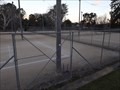 view gallery view gallerySE41.7 km |  Tennis Club Courts - Gloucester, NSW, Australia Tennis Club Courts - Gloucester, NSW, Australia
in Tennis Facilities These are the courts for hire for the rural town of Gloucester. posted by: Grahame Cookie location: New South Wales, Australia date approved: 01/08/2020 last visited: never |
 view gallery view galleryS41.7 km |  Gloucester Tops, Barrington Tops National Park, NSW, Australia Gloucester Tops, Barrington Tops National Park, NSW, Australia
in World Heritage Sites Gloucester Tops, Barrington Tops National Park, NSW, Australia posted by: Pensive Travellers location: New South Wales, Australia date approved: 01/02/2009 last visited: 12/29/2015 |
 view gallery view galleryS41.7 km |  Gloucester Tops, Barrington Tops National Park, NSW, Australia Gloucester Tops, Barrington Tops National Park, NSW, Australia
in National Parks of the World Gloucester Tops, Barrington Tops National Park, NSW, Australia posted by: Pensive Travellers location: New South Wales, Australia date approved: 01/01/2009 last visited: 12/29/2015 |
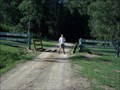
 view gallery view galleryS41.7 km |  Gloucester Tops Road Crossing 1 - Gloucester River, Maudville, NSW, Australia Gloucester Tops Road Crossing 1 - Gloucester River, Maudville, NSW, Australia
in Bridgeless Water Crossings Gloucester Tops Road Crossing 1 - Gloucester River, Maudville, NSW, Australia posted by: Pensive Travellers location: New South Wales, Australia date approved: 01/06/2009 last visited: 12/29/2015 |
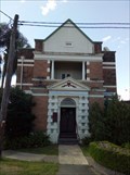 view gallery view gallerySE41.8 km |  Bank of NSW - Gloucester, NSW, Australia Bank of NSW - Gloucester, NSW, Australia
in Converted Bank Buildings This two-storey brick building, on the corner of a weird intersection, was built in 1914. posted by: Grahame Cookie location: New South Wales, Australia date approved: 05/17/2022 last visited: never |
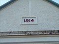 view gallery view gallerySE41.8 km |  1914 - Turner Freeman Lawyers - Gloucester, NSW, Australia 1914 - Turner Freeman Lawyers - Gloucester, NSW, Australia
in Dated Buildings and Cornerstones This two-storey building, on the corner of a weird intersection, was built in 1914. posted by: Grahame Cookie location: New South Wales, Australia date approved: 05/08/2022 last visited: never |
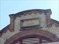 view gallery view gallerySE41.8 km | 1914 - Darrels Gourmet Butchery - Gloucester, NSW, Australia in Dated Buildings and Cornerstones This single-storey commercial building in Gloucester was built in 1914. posted by: Grahame Cookie location: New South Wales, Australia date approved: 05/14/2022 last visited: never |
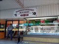 view gallery view gallerySE41.8 km |  Darrel's Gourmet Butchery - Gloucester, NSW, Australia Darrel's Gourmet Butchery - Gloucester, NSW, Australia
in Ye Olde Butcher Shoppe Darrel's Butchery is on the main commercial street of Gloucester. posted by: Grahame Cookie location: New South Wales, Australia date approved: 05/15/2022 last visited: never |
|